Rainfall finally returned to western Nebraska on September 5th. A large swath of rain occurred behind a cold front, and a broad upper trough of low pressure will spin off enough perturbations to produce better chances for rainfall into early this weekend. The last time measurable rain occurred in North Platte was on August 13th, with 1.08 inches reported. In Imperial the last occurrence of measurable rain was on the 18th of August with just one hundredth of an inch recorded. Parts of north central Nebraska have received more recent rainfalls, like the thirty two hundreths (0.32) of an an inch in Broken Bow on September 2nd, and the two hundredths (0.02) of an inch at Valentine on September 2nd.
|
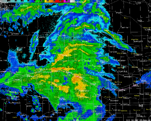
(Please click to enlarge image above of rainfall occurring across the region at 508 AM CDT September 5th)
MAX/MIN TEMPERATURE AND PRECIPITATION TABLE FOR NEBRASKA
NATIONAL WEATHER SERVICE NORTH PLATTE NE
925 AM CDT FRI SEP 05 2008

.BR LBF 0905 C DH00/TX/DH07/TAIRZP/PPDRZ/SF/SD
:
: WESTERN AND NORTH CENTRAL NEBRASKA - TEMPERATURE VALUES REPRESENT
: YESTERDAYS HIGHS...LOWS OVER THE PAST 12 HOURS...24 HOUR
: PRECIPITATION...SNOWFALL AND SNOWDEPTH ENDING AT 7 AM CDT
:
:       STATION NAME           MAX  / MIN  / 24-HOUR / SNOW  / SNOW
:                              TEMP / TEMP / PRECIP  / FALL  / DEPTH
:
LBF  :  NORTH PLATTE AIRPORT:   78  /  50  /  0.25   /  0.0  /   0
VTN  :  VALENTINE AIRPORT   :   74  /  51  /  0.02   /  0.0  /   0
BBW  :  BROKEN BOW AIRPORT  :   75  /  46  /  0.10   /    M  /   M
IML  :  IMPERIAL AIRPORT    :   78  /  51  /  0.37   /    M  /   M
ANW  :  AINSWORTH AIRPORT   :   72  /  52  /  0.02   /    M  /   M
ONL  :  ONEILL AIRPORT      :   75  /  52  /  0.00   /    M  /   M
OGA  :  OGALLALA AIRPORT    :   77  /  50  /  0.20   /    M  /   M
TIF  :  THEDFORD AIRPORT    :   73  /  50  /  0.11   /    M  /   M
.END

.BR LBF 0905 C DH07/TX/TN/PP/SF/SD
:
:COOPERATIVE OBSERVATIONS
:VALUES ARE FOR THE PAST 24 HOURS IN CENTRAL TIME
:
:STATION NAME            MAX  / MIN  / 24-HOUR / SNOW  / SNOW  / OBS
:                        TEMP / TEMP / PRECIP  / FALL  / DEPTH / HR
:
ANSN1:  ANSELMO 2SE     :  M  /   M  /  0.26   /  0.0  /   0  : 8 AM
CHMN1:  CHAMBERS        : 76  /  43  /     T   /  0.0  /   0  : 8 AM
ENDN1:  ENDERS          : 79  /  37  /  0.55   /  0.0  /   0  : 7 AM
ECSN1:  ERICSON 6WNW    : 74  /  40  /  0.07   /  0.0  /   0  : 8 AM
EUSN1:  EUSTIS 2NW      : 73  /  48  /  0.10   /  0.0  /   0  : 8 AM
GORN1:  GORDON 6N       :  M  /   M  /  0.43   /  0.0  /   0  : 6 AM
HAYN1:  HAYES CENTER    : 76  /  43  /  0.59   /  0.0  /   0  : 7 AM
IMPN1:  IMPERIAL        : 76  /  40  /  0.41   /  0.0  /   0  : 8 AM
KIGN1:  KILGORE 1NE     : 73  /  44  /  0.21   /  0.0  /   0  : 8 AM
KNGN1:  KINGSLEY DAM    : 79  /  45  /  0.28   /  0.0  /   0  : 7 AM
MDDN1:  MADRID          : 75  /  42  /  0.48   /  0.0  /   0  : 8 AM
MLSN1:  MULLEN 15S      : 71  /  40  /  0.19   /  0.0  /   0  : 8 AM
CABN1:  MEDICINE CK DAM : 78  /  46  /  0.09   /  0.0  /   0  : 7 AM
NPLN1:  N PLATTE EX FARM: 74  /  41  /  0.34   /  0.0  /   0  : 8 AM
OKSN1:  OSHKOSH 10NE    :  M  /   M  /  0.21   /  0.0  /   0  : 8 AM
SPCN1:  SPENCER 5SSE    : 76  /  46  /  0.00   /  0.0  /   0  :12 AM
STAN1:  STAPLETON 5W    : 79  /  42  /  0.38   /  0.0  /   0  : 7 AM
STKN1:  STOCKVILLE      :  M  /   M  /  0.15   /  0.0  /   0  : 8 AM
TAYN1:  TAYLOR          : 75  /  40  /  0.19   /  0.0  /   0  : 8 AM
WLLN1:  WALLACE 2W      : 76  /  42  /  0.48   /  0.0  /   0  : 7 AM
.END
|
 Page composition by Steve Carmel
