New Google Earth Maps
Over the past couple of months, web visitors may have noticed changes to background maps used on various National Weather Service products. New maps, powered by Google, have been incorporated into National Weather Service web pages. NOAA has entered into an agreement with Google to allow the use of these maps on our web pages.
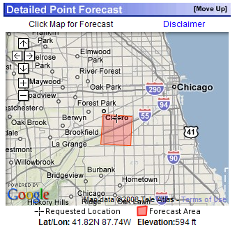
Starting this week, visitors will notice even more changes to National Weather Service websites. The National Weather Service web team has released a new version of the point and click forecast with a Google Maps interface for navigation, instead of the home-built maps used for the past couple of years.
The Google Maps display much more information than the old maps, and allow for zooming and panning to new locations. Progressive disclosure of detail as you zoom in greatly improves the ability for a user to pin point their location. There are plans to provide similar maps for the zone forecast pages.
Visitors to National Weather Service websites will note additional images powered by Google in the future. Planned uses include: weather story, graphical nowcasts, and within headline stories under Top News of the Day.
Return to News Archive