New Year's Day Weather for Northern Illinois:   Statistics for Chicago and Rockford


Rockford: 
The following statistics comprises 102 years of data. Data collection for Rockford was at the Greater Rockford Airport.

High Temperatures on New Years Day at Rockford

Frequency distribution of high temperatures for Rockford. This dataset shows that the most frequent range of high temperatures on New Year’s Day is in the 30 to 39 degree range. The normal high temperature on New Year’s Day at Rockford is 28 degrees.  The highest temperature recorded on New Year’s Day is 49 degrees which was set in 1916. The coldest high temperature on New Year’s Day is 4 degrees which occurred in 1974. Last year, the high temperature was 24 degrees.

Low Temperatures on New Years Day at Rockford

Frequency distribution of low temperatures for Rockford. This dataset shows that the most frequent range of low temperatures on New Year’s Day is in between 20 and 29 degrees. The normal low temperature on New Year’s Day in Rockford is 12 degrees. The lowest temperature recorded on New Year’s Day in Rockford is  -13 degrees which occurred in the 1924 and 1968. The highest low temperature for New Year’s Day was 40 degrees in 1950. Last year, the low temperature was 1 degree.

Precipitation on New Years Day at Rockford

Frequency distribution of precipitation for Rockford. This dataset shows that the most frequent amount of precipitation recorded on New Year’s Day is 0.00”, which accounts for 54% of the days in the dataset. The next most frequent range is the 0.02” to 0.25” group. The highest amount of precipitation on New Year’s Day occurred in 1948 when 1.37” of precipitation fell. This is one of two instances where over an inch of rain fell on New Year’s Day. Last year, 0.04" of precipitation fell.

Snowfall on New Years Day at Rockford

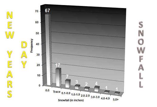
Frequency distribution of snowfall for Rockford. This dataset shows that the most frequent amount of snowfall recorded on New Year’s Day is 0.0”, which accounts for 66% of the days in the dataset. The next most frequent range is a trace. The highest amount of snow that has fallen on New Year’s Day is 9.0” in 1942. Last year, 1.4" of snow fell.


ADDITIONAL NEW YEARS DAY CLIMATE DATA     ( * MEANS LAST OCCURRENCE)

MAX TEMP
WARMEST

MIN TEMP
WARMEST
PCPN
WETTEST
SNOW
MOST
65
1876
43
1897, 1950
1.33
1948
5.0
1918
57
1897
41
1892
1.25
1891
4.6
1978
55
1892
40
1876
0.94
1965
4.4
1948
54
1890, 1891
37
1916
0.70
1941
4.3
1985
52
1916
36
1886, 1891
1905, 1941
0.68
1916
3.1
1984
49
1921, 2004
35
1874, 1911
1930, 2000
0.61
1985
48
1886, 1905
1950, 2000
34
1965, 1972
0.57
1892
46
1930, 1934, 1941
33
1890, 1954
1955, 1997
0.48
1890
45
2006
32
* 1996
0.47
1918
44
1875, 1939
31
1976, 1992
0.44
1876
 
MAX TEMP
COLDEST
MIN TEMP
COLDEST
PCPN
DRIEST
SNOW
LEAST
5
1969
-10
1969
0.00
* 2007
0.0
* 2007
7
1928
-9
1968
T
*2004
T
* 1993
8
1974, 1988
-6
1887
0.01
* 1997
0.1
1947, 1958, 1967
12
1924
-5
1901, 1924
0.02
1878, 1934, 1995
0.2
1995
13
1977
-3
1928, 1945
0.03
1879, 1943, 2006
0.3
1959
14
1920
-2
1974
0.04
1897, 1971
15
1901, 1968
-1
1988
0.05
1914, 2008
16
1885, 1887, 1899
0
1899, 1977, 1978
0.06
1911
17
1912, 1957
1
1920
0.08
1976, 1979
18
1900, 1922
2
1900, 1935
0.09
1921

TJH and ACS 12/24/08


  • National Weather Service
  • Chicago, IL Weather Forecast Office
  • 333 West University Drive
  • Romeoville, IL 60446
  • 815-834-1435 8am-8pm
  • Page Author: LOT Webmaster
  • Web Master's E-mail: w-lot.webmaster@noaa.gov
  • Page last modified: December 31st 2008 11:10 AM
USA.gov is the U.S. government's official web portal to all federal, state and local government web resources and services.