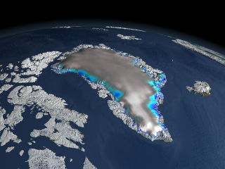
Changes in the Greenland and Antarctic ice sheets are critical in quantifying forecasts for sea level rise. Since its launch in January 2003, the ICESat elevation satellite has been measuring the change in thickness of these ice sheets. This image of Greenland shows the changes in elevation over the Greenland ice sheet between 2003 and 2006, The white regions indicate a slight thickening, while the blue shades indicate a thinning of the ice sheet. Gray indicates areas where no change in elevation was measured.
|


