|
|
 |
Mars Flyover Based on MOLA Data for the Carl Sagan Lecture
|
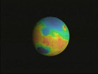
This visualization of the topography of Mars was created for Maria Zuber's Carl Sagan Lecture. The camera flies over several areas of interest. The south pole, Tharsis Rise, the north pole, and Valles Marineris. This animation was created using Maya and Renderman, using MOLA Topography data. The colors represent height - dark blue is about 8km deep and white is over 14km high (as measured from an arbitrary location picked as 'sea-level').
|
|
|
|
Flyover of Mars MOLA topography with false color texure
Duration: 1800.5 minutes
Available formats:
1280x720 (30 fps)
Frames
1280x720 (30 fps)
MPEG-2
283 MB
352x240 (29.97 fps)
MPEG-1
16 MB
160x80
PNG
9 KB
80x40
PNG
3 KB
320x242
JPEG
4 KB
1280x720 (29.97 fps)
MPEG-4
25 MB
320x180 (30 fps)
MPEG-1
15 MB
320x180 (30 fps)
X-FLV
3 MB
How to play our movies
|
|

|
|
MOLA color bar (dark blue is -8km, white is > 14km)
Available formats:
596 x 83
TIFF
89 KB
389 x 53
JPEG
2 KB
|
|
|
Back to Top
|
|
|
|

