Gold Rush prospectors gave the Fortymile River its name because it joins the Yukon River about 40 miles below Fort Reliance, an old Canadian trading post. In 1980, 392 miles of the river in east-central Alaska were designated as a National Wild and Scenic River by the Alaska National Interest Lands Conservation Act. BLM manages the wild and scenic river corridor as well as three campgrounds and the Fort Egbert National Historic Landmark.
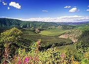 |
| The South Fork of the Fortymile National Wild and Scenic River |
Today's visitors can find relaxation, adventure or a touch of the past in the Fortymile region, which provided Interior Alaska's first gold rush in 1886. Float trips on the Fortymile National Wild and Scenic River offer scenic beauty, solitude and glimpses of gold-mining dredges, turn-of-the-century trapper cabins and abandoned townsites. Threading through this rugged landscape, the twisty and picturesque Taylor Highway leads motorists into the heart of the Fortymile and over American Summit to the historic town of Eagle on the Yukon River. The Top of the World Highway forks off the Taylor Highway, allowing access to Dawson City in Canada's Yukon Territory.