JASON Project: Flying over the Channel Islands
|
By using Landsat-7/ETM+ data and USGS DEM Elevation data, we are able to take a virtual tour of the Channel Islands and the coast of California. For more information on the Channel Islands, please visit (http://www.channel.islands.national-park.com).
|
|
|
|
Using data from the Landsat satellite and elevation data from USGS, we are able to virtually fly around the Santa Barbara-Channel Island area. This animation was created for the JASON Project.
Duration: 46.0 seconds
Available formats:
720x480 (29.97 fps)
Frames
320x240 (30 fps)
MPEG-1
6 MB
320x240
JPEG
10 KB
720x480 (29.97 fps)
MPEG-1
19 MB
720x480 (29.97 fps)
MPEG-2
38 MB
How to play our movies
|
|
|
|
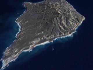
A still of the animation. This image is one of the Channel Islands, Santa Rosa.
Available formats:
2880 x 1944
TIFF
5 MB
160 x 80
PNG
23 KB
320 x 216
JPEG
12 KB
80 x 40
PNG
5 KB
|
|

|
|
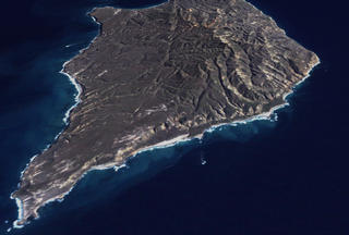
This image is of Santa Cruz Island.
Available formats:
2880 x 1944
TIFF
5 MB
320 x 216
JPEG
11 KB
|
|

|
|
This image shows the Vistor Center and Park Headquarters, which reside at the Ventura Harbor in Ventura, California.
Available formats:
2880 x 1944
TIFF
6 MB
320 x 216
JPEG
15 KB
|
| Animation Number: | 2658 |
| Animator: | Stuart A. Snodgrass (SVS) (Lead) |
| Completed: | 2002-11-13 |
| Scientist: | Darrel Williams (NASA/GSFC) |
| Instrument: | Landsat-7/ETM+ |
| Data set: | USGS/DEM |
| Data Collected: | 2001/02/04 |
| Series: | Landsat 7 |
| Video: | SVS2003-0002 * |
Keywords:
DLESE
>> Physical geography
GCMD
>> Location
>> Channel Islands
GCMD
>> Location
>> California
|
|
Please give credit for this item to
NASA/Goddard Space Flight Center
Scientific Visualization Studio |
*Please note: the SVS does not fulfill requests for copies of the tapes in our library. On some of our animation pages, there is a direct link to a video distribution service from which tapes, handled by the Public Affairs Office (PAO)/Goddard TV, including some of our animations may be ordered. General information on this service can be found here. |
|
Back to Top
|

