AMSR-E Arctic Sea Ice: 2005 to 2008
|
|
Sea ice is frozen seawater floating on the surface of the ocean. Some sea ice is semi-permanent, persisting from year to year, and some is seasonal, melting and refreezing from season to season. The sea ice cover reaches its minimum extent at the end of each summer and the remaining ice is called the perennial ice cover. In this animation, the globe slowly rotates one full rotation while the Arctic sea ice and seasonal land cover change throughout the years. The animation begins on September 21, 2005 when sea ice in the Arctic was at its minimum extent, and continues through September 20, 2008. This time period repeats twice during the animation, playing at a rate of one frame per day. Over the terrain, monthly data from the seasonal Blue Marble Next Generation fades slowly from month to month. Over the water, Arctic sea ice changes from day to day. This is a modification of animation ID #3404 : Global Rotation showing Seasonal Landcover and Arctic Sea Ice, which only covered a one-year time period. For a 3D stereo version of this visualization, please visit animation entry: #3578: AMSR-E Arctic Sea Ice: 2005 to 2008 - Stereoscopic Version
|
|

|
|
This animation shows seasonal changes in landcover and Arctic sea ice from 2005-09-21 through 2008-09-20. Frames are provided with date information and star field as a backdrop.
Duration: 1.2 minutes
Available formats:
1920x1080 (29.97 fps)
MPEG-2
247 MB
1280x720 (29.97 fps)
MPEG-4
63 MB
640x360 (29.97 fps)
MPEG-4
20 MB
512x288 (30 fps)
MPEG-1
9 MB
1920x1080 (60 fps)
Frames
(Combined)
1920x1080 (30 fps)
Frames
(Combined)
1920x1080
TIFF
2 MB
320x180
PNG
276 KB
How to play our movies
|
|

|
|
Frames of Arctic sea ice from 2005-09-21 through 2008-09-20 without date information and with alpha channel.
Available formats:
1920x1080 (60 fps)
Frames
1920x1080 (30 fps)
Frames
(Alpha)
1920x1080
TIFF
938 KB
320x180
PNG
78 KB
160x80
PNG
21 KB
80x40
PNG
5 KB
How to play our movies
|
|

|
|
Frames of the date overlay with alpha channel.
Available formats:
1920x1080 (60 fps)
Frames
(Dates)
1920x1080 (30 fps)
Frames
(Dates)
1920x1080
TIFF
49 KB
320x180
PNG
2 KB
How to play our movies
|
|
|
|
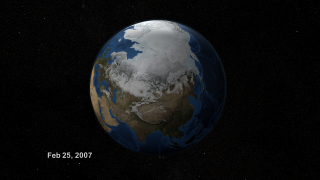
The Arctic Sea Ice on February 25, 2007 with a starfield backdrop image and date information.
Available formats:
3840 x 2160
TIFF
8 MB
1920 x 1080
TIFF
2 MB
1280 x 720
TIFF
1 MB
320 x 180
PNG
269 KB
|
|

|
|
The Arctic Sea Ice on February 25, 2007. This set provides images with date information and alpha channel.
Available formats:
3840 x 2160
TIFF
3 MB
1920 x 1080
TIFF
2 MB
1280 x 720
TIFF
1 MB
320 x 180
PNG
82 KB
|
|

|
|
The Arctic Sea Ice on March 10, 2007 with a starfield backdrop image and date information.
Available formats:
3840 x 2160
TIFF
7 MB
1920 x 1080
TIFF
2 MB
1280 x 720
TIFF
1 MB
320 x 180
PNG
269 KB
|
|

|
|
The Arctic Sea Ice on March 10, 2007. This set provides images with date information and alpha channel.
Available formats:
3840 x 2160
TIFF
3 MB
1920 x 1080
TIFF
2 MB
1280 x 720
TIFF
1 MB
320 x 180
PNG
82 KB
|
|

|
|
The Arctic Sea Ice on September 14, 2007 with a starfield backdrop image and date information.
Available formats:
3840 x 2160
TIFF
7 MB
1920 x 1080
TIFF
2 MB
1280 x 720
TIFF
1 MB
320 x 180
PNG
268 KB
|
|

|
|
The Arctic Sea Ice on September 14, 2007. This set provides images with date information and alpha channel.
Available formats:
3840 x 2160
TIFF
3 MB
1920 x 1080
TIFF
2 MB
1280 x 720
TIFF
1 MB
320 x 180
PNG
81 KB
|
|
|
|
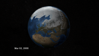
The Arctic Sea Ice on March 2, 2008 with a starfield backdrop image and date information.
Available formats:
3840 x 2160
TIFF
7 MB
1920 x 1080
TIFF
2 MB
1280 x 720
TIFF
1 MB
320 x 180
PNG
269 KB
|
|

|
|
The Arctic Sea Ice on March 2, 2008. This set provides images with alpha channel.
Available formats:
3840 x 2160
TIFF
3 MB
1920 x 1080
TIFF
2 MB
1280 x 720
TIFF
1 MB
320 x 180
PNG
82 KB
|
|

|
|
The Arctic Sea Ice on March 20, 2008 with a starfield backdrop image and date information.
Available formats:
3840 x 2160
TIFF
7 MB
1920 x 1080
TIFF
2 MB
1280 x 720
TIFF
1 MB
320 x 180
PNG
268 KB
|
|

|
|
The Arctic Sea Ice on March 20, 2008. This set provides images with alpha channel.
Available formats:
3840 x 2160
TIFF
3 MB
1920 x 1080
TIFF
2 MB
1280 x 720
TIFF
1 MB
320 x 180
PNG
81 KB
|
|

|
|
The star field still image used as a backdrop for the visualization.
Available formats:
3840 x 2160
TIFF
7 MB
1920 x 1080
TIFF
2 MB
1280 x 720
TIFF
1 MB
320 x 180
PNG
271 KB
|
|
|
Back to Top
|

