Ayles Ice Shelf Breakup Viewed from Northwest Coastline
|
On August 13, 2005, almost the entire Ayles Ice Shelf calved from the northern edge of Ellesmere Island. This continues the trend of dramatic loss of these ice shelves over the past century, reducing the remaining ice shelves there from six to five. Since 1900, approximately 90% of the Ellesmere Island ice shelves have calved and floated away. There is insufficient new ice formation to replace the ice that has been lost. The Ayles calving event was the largest in at least the last 25 years; a total of 87.1 sq km (33.6 sq miles) of ice was lost in this event, of which the largest piece was 66.4 sq km (25.6 sq. miles) in area. This piece is equivalent in size to approximately 11,000 football fields or a little larger than the island of Manhattan.
|
|
|
|
Animation zooms to view the ice shelf as seen from the northwest coastline and sequences through the satellite images showing the ice shelf breakup. An overlay shows the date and time, the region of interest and the area of the ice shelf broken.
Duration: 20.0 seconds
Available formats:
1280x720 (29.97 fps)
Frames
(Ayles WithOverlay)
512x288 (29.97 fps)
MPEG-1
4 MB
1280x720 (29.97 fps)
MPEG-2
24 MB
1280x720 (29.97 fps)
MPEG-4
16 MB
640x360 (29.92 fps)
MPEG-4
3 MB
1280x720 (59.94 fps)
Frames
(Ayles WithOverlay)
320x180
PNG
304 KB
160x80
PNG
69 KB
80x40
PNG
17 KB
1920x1080 (59.94 fps)
Frames
(Ayles withOverlay)
How to play our movies
|
|
|
|
|
Animation zooms to view the ice shelf as seen from the northwest coastline and sequences through the satellite images showing the ice shelf breakup. An overlay shows the date and time, the region of interest and the area of the ice shelf broken.
Available formats:
1280 x 720
TIFF
(Ayles WithOverlay)
1 GB
512 x 288
MPEG-1
4 MB
1280 x 720
MPEG-2
24 MB
1280 x 720
MPEG-4
16 MB
640 x 360
MPEG-4
3 MB
1280 x 720
TIFF
(Ayles WithOverlay)
2 GB
320 x 180
PNG
304 KB
160 x 80
PNG
69 KB
80 x 40
PNG
17 KB
1920 x 1080
TIFF
(Ayles withOverlay)
5 GB
|
|

|
|
This animation is identical to the above animation except that it has been reformatted to fit standard definition NTSC with a 4x3 aspect ratio.
Available formats:
720x480 (29.97 fps)
MPEG-2
11 MB
720x480 (29.97 fps)
Frames
(Ayles with Overlay)
320x213
PNG
355 KB
320x240 (29.97 fps)
MPEG-1
2 MB
640x480 (29.97 fps)
MPEG-1
8 MB
320x240 (29.97 fps)
X-FLV
852 KB
How to play our movies
|
|
|
|
|
This animation is identical to the above animation except that it has been reformatted to fit standard definition NTSC with a 4x3 aspect ratio.
Available formats:
720 x 480
MPEG-2
11 MB
720 x 480
TIFF
(Ayles with Overlay)
282 MB
320 x 213
PNG
355 KB
320 x 240
MPEG-1
2 MB
640 x 480
MPEG-1
8 MB
320 x 240
X-FLV
852 KB
|
|

|
|
The animation is identical to the first animation above but does not show the overlay that contains the date and the ice shelf locator.
Duration: 20.0 seconds
Available formats:
1280x720 (29.97 fps)
Frames
(Ayles)
512x288 (29.97 fps)
MPEG-1
4 MB
1280x720 (29.97 fps)
MPEG-2
24 MB
1280x720 (29.97 fps)
MPEG-4
16 MB
640x360 (29.92 fps)
MPEG-4
3 MB
1280x720 (59.94 fps)
Frames
(Ayles)
320x180
PNG
304 KB
1920x1080 (59.94 fps)
Frames
(Ayles)
How to play our movies
|
|
|
|
|
The animation is identical to the first animation above but does not show the overlay that contains the date and the ice shelf locator.
Available formats:
1280 x 720
TIFF
(Ayles)
674 MB
512 x 288
MPEG-1
4 MB
1280 x 720
MPEG-2
24 MB
1280 x 720
MPEG-4
16 MB
640 x 360
MPEG-4
3 MB
1280 x 720
TIFF
(Ayles)
1 GB
320 x 180
PNG
304 KB
1920 x 1080
TIFF
(Ayles)
2 GB
|
|
|
|
This animation is identical to the above animation except that it has been reformatted to fit standard definition NTSC with a 4x3 aspect ratio.
Available formats:
720x480 (29.97 fps)
MPEG-2
11 MB
720x480 (29.97 fps)
Frames
(Ayles)
320x213
PNG
356 KB
320x240 (29.97 fps)
MPEG-1
2 MB
640x480 (29.97 fps)
MPEG-1
8 MB
320x240 (29.97 fps)
X-FLV
844 KB
How to play our movies
|
|
|
|
|
This animation is identical to the above animation except that it has been reformatted to fit standard definition NTSC with a 4x3 aspect ratio.
Available formats:
720 x 480
MPEG-2
11 MB
720 x 480
TIFF
(Ayles)
281 MB
320 x 213
PNG
356 KB
320 x 240
MPEG-1
2 MB
640 x 480
MPEG-1
8 MB
320 x 240
X-FLV
844 KB
|
|

|
|
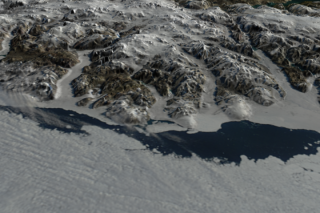
Image of Ayles ice shelf on August 13, 2005 at time 00:55 GMT
Available formats:
2560 x 1920
TIFF
4 MB
320 x 240
PNG
397 KB
|
|

|
|
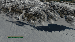
Image of Ayles ice shelf on August 14, 2005 at time 00:00 GMT.
Available formats:
2560 x 1920
TIFF
4 MB
320 x 240
PNG
404 KB
|
|

|
|
Overlay containing the date, region of interest outline and ice shelf area.
Available formats:
1280x720 (29.97 fps)
Frames (Overlay)
320x180
PNG
6 KB
1280x720 (59.94 fps)
Frames (Overlay)
1920x1080 (59.94 fps)
Frames (Overlay)
How to play our movies
|
|
|
|
|
Overlay containing the date, region of interest outline and ice shelf area.
Available formats:
1280 x 720
TIFF
57 MB
320 x 180
PNG
6 KB
1280 x 720
TIFF
114 MB
1920 x 1080
TIFF
218 MB
|
|
|
Back to Top
|

