| Home >> | Advanced Search >> |
|
|
|
Astronaut Photography of Earth - Display Record
ISS011-E-6717

Low-resolution Browse Image
(Most browse images are not color adjusted.)Images
Conditions for Use of Images >>Image Transformation Tutorial >> Saving, Color Adjusting, and Printing Images >>
Images to View on Your Computer Now
| File Name | File Size (bytes) | Width | Height | Annotated | Cropped | Purpose | Comments | |
|---|---|---|---|---|---|---|---|---|
| View | ISS011-E-6717.JPG | 133110 | 640 | 439 | No | No | ||
| View | ISS011-E-6717.JPG | 315784 | 539 | 341 | Yes | Yes | NASA's Earth Observatory web site |
Large Images to Request for Downloading
| File Name | File Size (bytes) | Width | Height | Annotated | Cropped | Purpose | Comments | |
|---|---|---|---|---|---|---|---|---|
| Request | ISS011-E-6717.JPG | 513982 | 1600 | 1098 | No | No | ||
| Request | ISS011-E-6717_2.JPG | 513998 | 1600 | 1042 | No | No | Original file from camera | |
| Request | ISS011-E-6717.JPG | 944203 | 1000 | 652 | No | Yes | NASA's Earth Observatory web site |
Download a Keyhole Markup Language (KML) file for use in Google Earth.
Electronic Image Data
Camera Files >> No sound file available.Identification
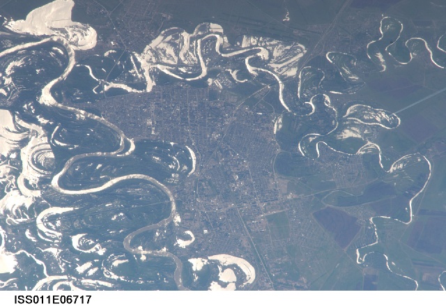
Mission: ISS011 Roll: E Frame: 6717 Mission ID on the Film or image: ISS011Country or Geographic Name: KAZAKHSTAN
Features: URAL'SK, URAL R., MARSH, GLINT
Center Point Latitude: 51.2 Center Point Longitude: 51.4 (Negative numbers indicate south for latitude and west for longitude)
Stereo: (Yes indicates there is an adjacent picture of the same area)
ONC Map ID: JNC Map ID:
Camera
Camera Tilt: High ObliqueCamera Focal Length: 800mm
Camera: N1: Nikon D1
Film: 2000E : 2000 x 1312 pixel CCD, RGBG imager color filter.
Quality
Film Exposure:Percentage of Cloud Cover: 10 (0-10)
Nadir
Date: 20050522 (YYYYMMDD)GMT Time: 120843 (HHMMSS)Nadir Point Latitude: 51.8, Longitude: 58.0 (Negative numbers indicate south for latitude and west for longitude)
Nadir to Photo Center Direction: West
Sun Azimuth: 260 (Clockwise angle in degrees from north to the sun measured at the nadir point)
Spacecraft Altitude: 186 nautical miles (344 km)
Sun Elevation Angle: 34 (Angle in degrees between the horizon and the sun, measured at the nadir point)
Orbit Number: 1164
Captions
Uralsk, KazakhstanThe approximate boundary between Europe and Asia is defined by the Ural River and the Ural Mountains to its north. The Ural River flows to the great, inland Caspian Sea, and gives its name to the city of Uralsk on its banks. Lying just inside the Kazakh border with Russia, Uralsk is an agricultural and industrial center, and has been an important trade stop since the early 1600s. Barge traffic has passed up and down the Ural River between the Caspian Sea and the Ural Mountains for centuries. Today it is one of the major entry points for rail traffic from Europe to Siberia, servicing the many new oil fields in the Caspian basin and the industrial cities of the southern Urals.
International Space Station astronauts acquired a series of images of Uralsk, highlighting the city under different lighting conditions. This view shows the sunglint (light reflected from the water surface towards the observer) on the rivers, lakes, and ponds of the Ural floodplain (right side of image) and that of a tributary, the Chogan River (bottom). The cityscape of Uralsk, on the headland between the two, is relatively difficult to see because the water and sunglint dominate the scene.
Download Packaged File.
This option downloads the following items, packaged into a single file, if they are available:
- Browse image
- Cataloged information with captions
- Camera file
- Sound file
Server: 2 |
This service is provided by the International Space Station program. |
Recommended Citation: |
||

