A seagull flies over the California Coastal National Monument which stretches along the entire coast of California and extends 12 miles into the Pacific Ocean.  The Monument includes 20,000 rocks, islands, pinnacles and reefs.
BLM
U.S. DEPARTMENT OF THE INTERIOR
BUREAU OF LAND MANAGEMENT
Wagon wheel in the Carrizo Plain National Monument Geothermal Well Rock Climbing Wild Horses River Rafters on Cache Creek
California
BLM>California
Print Page

In the Spotlight
Bob Abbey, Director, Bureau of Land Management

Bob Abbey, Director
Bureau of Land Management


Historic Route 66

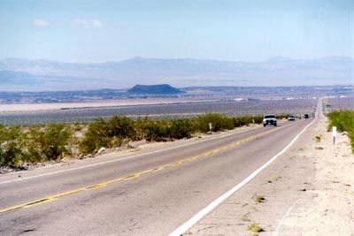
Historic Route 66 near Amboy Crater

Route 66 captures and represents the pioneering spirit of emigrants set on coming west.  Originally, there were no official roads crossing America. There were dirt trails used by settlers and there were railroads. Individual towns established themselves around these transportation routes.

When someone wanted to travel to another town with their vehicle, they either took the established trail or used a frontage access road for the railroad. Since towns were situated on an existing railroad line or trail, the primary trading businesses were located on that route. That led to the term “Main Street” for a town’s business.

In California, Route 66 runs from the Colorado River west of Needles through Goffs, Essex, Danby, Chambless, Amboy, Ludlow, and Barstow before reaching Los Angeles. The spirit and grandeur of a pioneer trail that helped to settle the west continues to live on!


cartoon of Route 66 route markerFunny.bytes: Route 66 - The Adventure
Take a cartoon drive along Route 66, with our two road adventurers.  Funny.bytes is an occasional look at the lighter side of BLM issues.

How the BLM and other Interior Bureaus are implementing the American Recovery and Reinvestment Act of 2009.

Recovery Act Logo


Arcata Redding Alturas Surprise Ukiah Northern California District Central California District Mother Lode Hollister Bishop Bakersfield Ridgecrest California Desert District Palm Springs/South Coast Barstow Needles El Centro Eagle Lake Map of BLM California Field Offices

BLM manages 15.2 million acres of public lands in California - nearly 15% of the state's land area - and 1.6 million acres in northwestern Nevada.  BLM California also administers 47 million acres of subsurface mineral estate underlying federal surface land, 2.5 million acres underlying privately owned land, and 592,000 acres of Native American tribal land where BLM has trust responsibility for mineral operations.


Employee Profile:  Charlie Wright 

Charlie Wright

Charlie Wright

Charlie Wright is a realty specialist with BLM-California's Eagle Lake Field Office, but part of him remains loyal to his San Diego hometown.  Read more... 


Frequently Requested 


Newsbyte logo - click here to go to News.bytes Archive
For more news about BLM in California...
 
subscribe to News.bytes, our
weekly e-newsletter


Bureau of Land Management
California State Office
2800 Cottage Way, Suite W-1623
Sacramento, CA 95825-1886
Phone: (916) 978-4400
Fax: (916) 978-4416
TDD (916) 978-4419
Contact us by Email