Fly up the Chesapeake Bay to Harrisburg, Pennsylvania
|
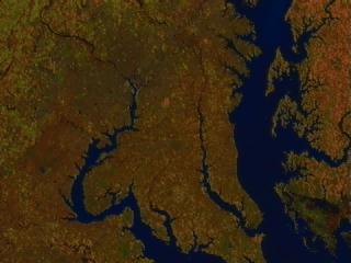
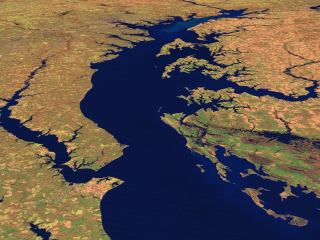
This scene shows Landsat Thematic Mapper data from the shortwave infrared (TM band 5), infrared (TM band 4), and visible green (TM band 2) channels of the Chesapeake Bay. The Patuxent River can be seen running parallel to the Bay on the left, while the Choptank River enters the Bay on the right. Annapolis and Kent Island (flat look-down image) is from the 2nd of October, 1997, all other images are from 16 November, 1996. The change in color between these dates (predominately green in October, red in November) result from seasonal changes in vegetation.
|
|
|
|
A flyby up the Chesapeake Bay from Norfork to Harrisburg. Created by draping Landsat imagery over elevation data.
Duration: 1.0 minutes
Available formats:
320x240 (10 fps)
QUICKTIME
4 MB
352x240 (29.97 fps)
MPEG-1
8 MB
320x240
JPEG
12 KB
160x80
PNG
20 KB
80x40
PNG
5 KB
320x238
JPEG
10 KB
How to play our movies
|
|

|
|
Annapolis, MD and Kent Island
Available formats:
900 x 900
TIFF
1 MB
160 x 80
PNG
24 KB
450 x 450
JPEG
190 KB
|
|
|
|
Chesapeake Bay
Available formats:
2560 x 1920
TIFF
10 MB
320 x 240
GIF
59 KB
640 x 480
JPEG
310 KB
1280 x 960
TIFF
3 MB
160 x 80
PNG
24 KB
|
|

|
|
Middle Region of the Chesapeake Bay
Available formats:
2560 x 1920
TIFF
10 MB
320 x 240
GIF
53 KB
640 x 480
JPEG
301 KB
1280 x 960
TIFF
3 MB
|
| Animation Number: | 845 |
| Animator: | Jesse Allen (SVS) (Lead) |
| Completed: | 1999-04-09 |
| Scientist: | Darrel Williams (NASA/GSFC) |
| Instrument: | Landsat-5/TM |
| Data Collected: | 1996/11/16, 1997/10/02 |
| Video: | SVS1999-1002 * |
Keywords:
SVS
>> Chesapeake Bay
DLESE
>> Human geography
DLESE
>> Physical geography
|
More Information on this topic available at:
stories/Landsat/index.html
|
|
Please give credit for this item to
NASA/Goddard Space Flight Center
Scientific Visualization Studio |
*Please note: the SVS does not fulfill requests for copies of the tapes in our library. On some of our animation pages, there is a direct link to a video distribution service from which tapes, handled by the Public Affairs Office (PAO)/Goddard TV, including some of our animations may be ordered. General information on this service can be found here. |
|
Back to Top
|

