U.S. DEPARTMENT OF THE INTERIOR
BUREAU OF LAND MANAGEMENT


Arizona
|
Print Page | ||||||||||
| Fire & Aviation | |||||||||||
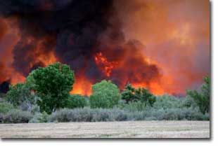
 Each fire zone provides initial attack and extended attack through dispatch offices, many of which are run by an interagency staff of professionals. When a fire exceeds initial attack capabilities, the dispatch offices place orders for fire resources to the appropriate coordination center. More information on dispatching in the southwest area can be found on the Southwest Area Coordination Center web site. Each fire zone provides initial attack and extended attack through dispatch offices, many of which are run by an interagency staff of professionals. When a fire exceeds initial attack capabilities, the dispatch offices place orders for fire resources to the appropriate coordination center. More information on dispatching in the southwest area can be found on the Southwest Area Coordination Center web site.CONTACT US BLM Arizona State Office Phoenix, Arizona 602-417-9200 BLM Arizona Strip District Fire Zone St. George, Utah 435-688-3200 BLM Phoenix District Fire Zone Phoenix, Arizona 623-580-5500 or 1-800-309-7081 BLM Gila District Fire Zone Safford, Arizona 928-348-4400 BLM Colorado River Fire Zone Yuma, Arizona 928-505-1200 More than 2.7 million acres of BLM-administered public lands lie within the area known as the “Arizona Strip,” located in the northern portions of Coconino and Mohave counties, Arizona, north and west of the Colorado River. The Arizona Strip District Fire Management Program is an interagency effort between the BLM and the Dixie National Forest in Utah. There is a broad spectrum of resource issues involving fire within this region, including: vegetation classification; management constraints for fighting fires in areas such as wilderness, desert tortoise habitat and grazing areas; access to remote locations; understanding the resources values to be protected; and, the overall management objectives for the environment. The fire season on the Arizona Strip usually runs from May through early October, with the number of fires peaking in June and July. From 1980 to 2003, there was an annual average of 85 wildland fires, ranging from 37 in 1987 and 2002 to a high of 161 fires in 1996. These fires burned an average total of 7,450 acres each year. Lightning is the most common cause of fires, accounting for approximately 81 percent of all fires burning 96 percent of the total acres. Fortunately, nearly 90 percent of these fires burned less than 10 acres, and less than two percent consumed more than 1,000 acres. Arizona Strip Links
Phoenix /Kingman Fire Zone The Phoenix/Kingman Fire Management Zone is administered jointly by the BLM’s Phoenix and Kingman Field Offices. The zone’s fire program is responsible for the protection of nearly five million acres of BLM public lands and an additional 1.1 million acres within the Barry M. Goldwater Air Force Training Range. There are a variety of fuel types within this region, including the Sonoran Desert ecosystem, grass lands, desert oak/chaparral with intermixed manzanita, desert shrub and ponderosa pine. Elevation ranges from 1,000 feet in the southern portion of the zone and rise to 8,000 feet in the northern ranges. Fire season usually begins in mid-March and ends in early September, with an annual average of 61 wildfires, burning an average of 9,000 acres of BLM public lands each year. 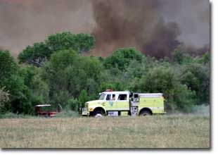 Gila District Fire Zone Gila District Fire ZoneArizona’s Gila District Fire Zone contains approximately 2.4 million acres. From 1980 through 2003, fire professionals have responded to 521 wildfires. The zone sees an average of 27 fires each year on BLM public lands, with approximately 3,000 acres consumed per year. A typical fire season runs from March through September. Lightning strikes cause 60 percent of the fires that occur within the zone. The Gila District Fire Management Zone is a full participant in the greater southeastern Arizona Interagency Fire Management Zone. In this cooperative effort, a variety of agencies have joined forces to fight wildland fires. Participants include the BLM, Forest Service, U.S. Fish and Wildlife Service, Bureau of Indian Affairs, National Park Service and Arizona State Land Department. Yuma/Havasu Fire Zone Historically, wildfire was not a major cause of disturbance within the lower Colorado River riparian ecosystem prior to 1935. However, flood control activities initiated after the completion of Hoover Dam allowed the wide-spread establishment of the exotic salt cedar (Tamarix ramosissima/chinensis). The elimination of annual floods limited the ability of native plant communities to regenerate resulting in a system where wildfire has now become the major disturbance influencing riparian stand development. Sonoran Desert vegetation is not considered to be fire adapted or dependent. The invasion of non-native species to the Yuma/Havasu region has created areas that are now prone to high intensity fires with high rates of spread. The vegetation in this management unit is dominated by desert shrubs, trees and cacti. Deep upland sites have overstories of mesquite, palo verde, and ironwood, with understories of perennial and annual grasses and forbs. Between 1984 and 2003 approximately 98 percent of fires in this zone were human caused and generally occurred between the months of February and October. Most of these fires occurred near main travel corridors and rivers. The 20-year annual average for all fire causes equates to 36 fires per year, burning an average of 3,000 acres per year. The number of fires varies from year to year. Fires are largely confined to the Lower Colorado River North, Lower Colorado River South and Gila River regions, and are almost entirely human caused. |
|||||||||||