Skip Navigation
NOAA
weather.gov
National Weather Service Weather Forecast Office
Paducah, KY
Search for:
NWS
All NOAA
Home
Site Map
News
Organization
Local forecast by
"City, St" or Zip Code
Current Hazards
Watches/Warnings
Outlooks
Submit Report
Current Conditions
Observations
Radar
Satellite
Observed Precip
Forecasts
Forecast Discussion
Local Area
Activity Planner
Aviation Weather
Fire Weather
Severe Weather
Hurricane Center
Hydrology
Rivers & Lakes
Climate
Local
National
Drought
More...
Weather Safety
Preparedness
Weather Radio
StormReady
SkyWarn
Additional Info
Items of Interest
Education Resources
Coop Observer
Top News Archives
Our Office
Contact Us
Contact Info
Feedback
Top News of the Day
Links removed from the left-hand menu are now found under "Items of Interest"
Watches &
Warnings
Observations
Forecast Graphics
Rivers &
Lakes
Climate
Local Overview
Click on the map below for the latest forecast.
Last map update: Fri, Aug. 21, 2009 at 8:48:52 pm CDT
Read watches, warnings & advisories
Zoom
Out
Hazardous Weather Outlook
Short Term Forecast
Weather Story
Radar
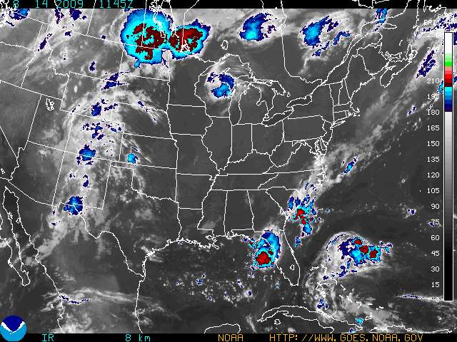
Satellite
Weather Map
FORECAST-AT-A-GLANCE
PADUCAH
Tonight
Partly
Cloudy
Lo
60 °F
Saturday
Partly
Sunny
Hi
77 °F
Saturday
Night
Partly
Cloudy
Lo
54 °F
Sunday
Sunny
Hi
80 °F
Sunday
Night
Mostly
Clear
Lo
56 °F
Monday
Sunny
Hi
85 °F
EVANSVILLE
Tonight
Scattered
Showers
Lo
61 °F
Saturday
Mostly
Cloudy
Hi
75 °F
Saturday
Night
Partly
Cloudy
Lo
54 °F
Sunday
Mostly
Sunny
Hi
78 °F
Sunday
Night
Mostly
Clear
Lo
55 °F
Monday
Sunny
Hi
84 °F
CAPE GIRARDEAU
Tonight
Partly
Cloudy
Lo
58 °F
Saturday
Mostly
Sunny
Hi
77 °F
Saturday
Night
Mostly
Clear
Lo
53 °F
Sunday
Sunny
Hi
80 °F
Sunday
Night
Clear
Lo
56 °F
Monday
Sunny
Hi
84 °F
Quad State Outlook
Friday Night
Fog
Low
Click for risk level information.
CURRENT CONDITIONS
LOCATION
TIME[cst]
WEATHER
TEMP
DEWPT
HUMIDITY
WIND
PRESSURE
Cape Girardeau, MO
18:53
Mostly Cloudy
71ºF
62ºF
73%
NW 6 mph
29.89 in
Carbondale, IL
18:52
A Few Clouds
73ºF
58ºF
59%
NW 7 mph
29.91 in
Evansville, IN
18:54
Fair
71ºF
60ºF
68%
SW 5 mph
29.87 in
Mount Carmel, IL
19:25
Partly Cloudy
64ºF
63ºF
96%
Calm mph
29.88 in
Mount Vernon, IL
19:35
Mostly Cloudy
70ºF
55ºF
60%
W 6 mph
29.91 in
Owensboro, KY
18:56
A Few Clouds
74ºF
67ºF
79%
SW 5 mph
29.88 in
Paducah, KY
18:53
A Few Clouds
73ºF
61ºF
66%
SW 5 mph
29.89 in
Poplar Bluff, MO
18:53
Fair
75ºF
57ºF
54%
W 3 mph
29.91 in
CLICK ON LOCATION FOR THREE DAYS OF OBSERVATIONS
CLIMATE
TODAY'S CLIMATE STATISTICS
PADUCAH
EVANSVILLE
OBSERVED
HIGH: 82ºF at 303PM
LOW: 66ºF at 557AM
HIGH: 83ºF at 135PM
LOW: 64ºF at 520AM
NORMAL
HIGH: 87ºF
LOW: 64ºF
HIGH: 87ºF
LOW: 64ºF
LAST YEAR
HIGH: 86ºF
LOW: 71ºF
HIGH: 82ºF
LOW: 70ºF
RECORDS
HIGH: 100ºF in 1987
LOW: 50ºF in 1950
HIGH: 101ºF in 1983
LOW: 49ºF in 1950
PRECIP
0.00" TODAY
3.38" MONTH TO DATE
0.00" TODAY
1.80" MONTH TO DATE
SUNRISE
&
SUNSET
AUGUST 21
SUNRISE: 617AM SUNSET: 739PM
AUGUST 22
SUNRISE: 618AM SUNSET: 737PM
AUGUST 21
SUNRISE: 611 SUNSET: 735PM
AUGUST 22
SUNRISE: 611AM SUNSET: 734PM
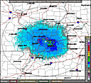
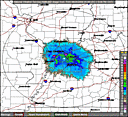
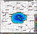
RADARS
PADUCAH RADAR
STANDARD
ENHANCED
EVANSVILLE RADAR
STANDARD
ENHANCED
HOPKINSVILLE RADAR
STANDARD
ENHANCED
QUICKLINKS
WEATHER
CLIMATE
RIVERS
SEVERE WEATHER INFORMATION
HAZARDOUS WEATHER OUTLOOK
REGIONAL WEATHER SUMMARY
STORM REPORT GRAPHIC
SEVERE WEATHER BRIEFS
E-SPOTTER
PAST WEATHER EVENTS
PAST 24 HOURS
LOCAL
NATIONAL
OBSERVED RIVER STAGES
FORECAST RIVER STAGES
RIVER INFORMATION
National Weather Service
Paducah, KY Weather Forecast Office
8250 Kentucky Highway 3520
West Paducah, KY 42086-9762
270-744-6440
Page Author: PAH Webmaster
Web Master's E-mail:
w-pah.webmaster@noaa.gov
Page last modified: 13-Jul-2007 9:52 PM UTC
Disclaimer
Credits
Glossary
Privacy Policy
About Us
Career Opportunities