Skip all navigation and jump to content Jump to site navigation Jump to section navigation.
NASA Logo - Goddard Space Flight Center + Visit NASA.gov
HOME PROJECTS RESOURCES SEARCH MAP

+ Advanced Search
Home
Home
View Most Recently Released Imagery
View Gallery of Imagery: A topical collection of SVS Imagery
Search Imagery by the keywords assigned to it
Search Imagery by the instruments that supplied data for a visualization product
Search Imagery by the series of visualizations that have been produced
Search Imagery by the scientist providing the data used in a visualization product
Search Imagery by the animator that created the product
Search Imagery by the identification number assigned to the visualization product
See other search options
Learn about the SVS Image Server
  + About the Server
  + Animation List
  + How to Use the Server


  + RSS Feeds
  + Podcasts


  + Opportunities
blank image
Previous Animation
Next Animation
Fire Observations - As the World Turns

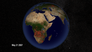
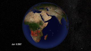
From space, we can understand fires in ways that are impossible from the ground. NASA research has contributed to much improved detection of fire for scientific purposes using satellite remote sensing and geographic information systems. This has helped advance our understanding of the impacts of fire in many areas of earth science, including atmospheric chemistry and the impacts on protected areas. This research has led to the development of a rapid response system widely used throughout the world for both natural resource management and for firefighting by providing near real-time information. In this animation of fires around the globe in 2007, each red dot marks a new fire. From brush fires in Africa to forest fires in North America, satellites are locating every significant fire on Earth to within one kilometer. More information on the Fire Information for Resource Management (FIRMS) is available at http://maps.geog.umd.edu/firms/

Fires around the world from Jan 1 through Dec 31, 2007.    Fires around the world from Jan 1 through Dec 31, 2007.
Duration: 60.0 seconds
Available formats:
  1280x720 (29.97 fps) MPEG-4   64 MB
  512x288 (30 fps) MPEG-1   10 MB
  1280x720 (30 fps) Frames
  1280x720 (60 fps) Frames
  320x180     PNG           288 KB
  160x80       PNG           64 KB
  80x40         PNG           16 KB
  3840x2160 TIFF         8 MB
  1280x720 (30 fps) Frames
  640x360 (30 fps) MPEG-4   10 MB
How to play our movies


Fires on June 7, 2007    Fires on June 7, 2007

Available formats:
  3840 x 2160     TIFF 9 MB
  320 x 180         PNG     289 KB

Animation Number:3597
Completed:2009-06-01
Animators:Lori Perkins (NASA/GSFC) (Lead)
 Greg Shirah (NASA/GSFC)
Producer:Michelle Williams (UMBC)
Scientists:Chris Justice (University of Maryland)
 Louis Giglio (SSAI)
 Inbal Becker Reshef (University of Maryland)
Platforms/Sensors/Data Sets:Earth Probe/TOMS
 GOES-12
 Landsat-7/ETM+
 QuikSCAT/SeaWinds
 TRMM/TMI
 Terra/ASTER
 Terra/MISR
 Terra/MODIS
 SRTM
 Gridded Population of the World (Version 3 Beta)
 Earth Probe/TOMS/Aerosol Index
 10-meter DEM
 GTOPO30
 QuikSCAT/SeaWinds/Wind
 Terra and Aqua/MODIS/Fire Location (Jan 1, 2007 through Dec 31, 2007)
 Terra/MODIS/NDVI
Data Collected:2001/10/01 - 2002/09/30
Series:Fires
 Multisensor Fire Observations
Goddard TV Tape:G2008-042HD -- HD Fires, Ozone, and Air Quality RT
Keywords:
DLESE >> Atmospheric science
SVS >> Biscuit
DLESE >> Forestry
SVS >> HDTV
SVS >> Hayman
DLESE >> Natural hazards
SVS >> Rodeo
GCMD >> EARTH SCIENCE >> Biosphere >> Ecological Dynamics >> Fire Occurrence
 
 
Please give credit for this item to
NASA/Goddard Space Flight Center Scientific Visualization Studio


Back to Top

USA.gov logo - the U.S. Government's official Web portal. + Privacy Policy and Important Notices
+ Reproduction Guidelines
NASA NASA Official:
Content Contact:
Curator: