Erythemal Index for August 2000 through July 2001: Full Earth (With Dates)
|
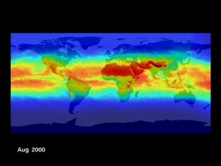
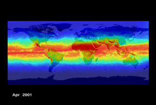
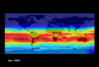
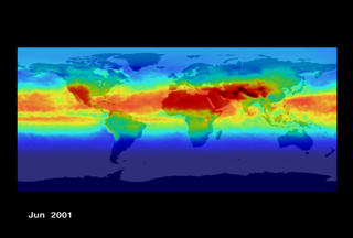
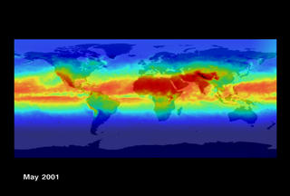
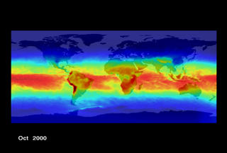
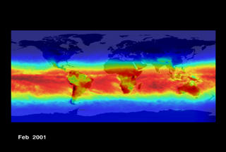
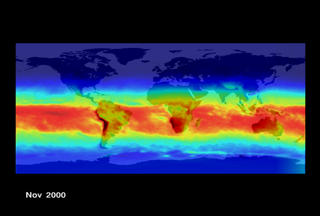
The Erythemal Index is a measure of ultraviolet radiation (UV) at ground level on the Earth. UV exists to the left of the visible spectrum and is divided into three components (UV-A, UV-B and UV-C). UV-B (290-320 wavelengths) is the most dangerous form of UV radiation that can reach ground level. Atmospheric ozone shields life at the surface from most of the harmful components of solar radiation. Chemical processes in the atmosphere can effect the level of protection provided by the ozone in the upper atmosphere. This thinning of the atmospheric ozone in the stratosphere leads to elevated levels of UV-B at ground level and increases the risks of DNA damage in living organisms.
|
|
|
|
Flat view of the Earth showing reds and yellows over the
equatorial regions (denoting the higher ground levels of UV radiation) and cool
greens, blues, and purples as you move towards the poles (denoting lower ground
levels of UV radiation).
Duration: 1.0 seconds
Available formats:
320x240 (30 fps)
MPEG-1
209 KB
160x80
PNG
21 KB
80x40
PNG
6 KB
320x240
JPEG
8 KB
320x240 (30 fps)
X-FLV
147 KB
How to play our movies
|
|
|
|
April, 2001
Available formats:
720 x 486
TIFF
175 KB
320 x 216
JPEG
11 KB
|
|

|
|
August, 2000
Available formats:
720 x 486
TIFF
177 KB
320 x 216
JPEG
11 KB
|
|

|
|
December, 2000
Available formats:
720 x 486
TIFF
168 KB
320 x 216
JPEG
11 KB
|
|

|
|
February, 2001
Available formats:
720 x 486
TIFF
171 KB
320 x 216
JPEG
11 KB
|
|
|
|
January, 2001
Available formats:
720 x 486
TIFF
169 KB
320 x 216
JPEG
11 KB
|
|

|
|
July, 2001
Available formats:
720 x 486
TIFF
176 KB
320 x 216
JPEG
11 KB
|
|
|
|
June, 2001
Available formats:
720 x 486
TIFF
173 KB
320 x 216
JPEG
11 KB
|
|

|
|
March, 2001
Available formats:
720 x 486
TIFF
172 KB
320 x 216
JPEG
11 KB
|
|
|
|
May, 2001
Available formats:
720 x 486
TIFF
178 KB
320 x 216
JPEG
11 KB
|
|

|
|
November, 2000
Available formats:
720 x 486
TIFF
170 KB
320 x 216
JPEG
11 KB
|
|
|
|
October, 2000
Available formats:
720 x 486
TIFF
174 KB
320 x 216
JPEG
11 KB
|
|

|
|
September, 2000
Available formats:
720 x 486
TIFF
174 KB
320 x 216
JPEG
11 KB
|
| Animation Number: | 2223 |
| Completed: | 2001-06-25 |
| Animator: | Michael Mangos (GST) (Lead) |
| Scientist: | Richard McPeters (NASA/GSFC) |
| Platform/Sensor/Data Set: | Earth Probe/TOMS (2000/08/01-2001/07/31) |
| Series: | Erythemal UV |
| Video: | SVS2001-0020 * |
Keywords:
DLESE
>> Atmospheric science
SVS
>> UV
|
|
Please give credit for this item to
NASA/Goddard Space Flight Center
Scientific Visualization Studio |
*Please note: the SVS does not fulfill requests for copies of the tapes in our library. On some of our animation pages, there is a direct link to a video distribution service from which tapes, handled by the Public Affairs Office (PAO)/Goddard TV, including some of our animations may be ordered. General information on this service can be found here. |
|
Back to Top
|

