|

PHILIPPINES HIT BY ANOTHER TYPHOON
Within a week's time, the northern Philippines were hit by two tropical cyclones.
Less than a week ago, then Tropical storm Kujira inundated parts of southern
Luzon in the northeast-central Philippines with torrential rains. Recently
Typhoon Chan-hom (known locally as "Emong") made landfall on the northwest coast
of Luzon, bringing strong winds, heavy rains and yet more flooding to the
beleaguered island.
Chan-hom formed off of the southeast coast of Vietnam on the evening (local time)
of 3 May 2009 as a tropical depression. It was upgraded overnight to a minimal
tropical storm as it slowly drifted northward. Chan-hom continued to drift
northward on the 4th, paralleling the coast of Vietnam, with a slight increase
in intensity. The system continued to gradually intensify on the 5th before
turning westward across the central South China Sea in the direction of Luzon in
the northern Philippines. The Tropical Rainfall Measuring Mission satellite
(better known as TRMM) was launched way back in November of 1997 with the objective
of measuring rainfall over the Tropics. Armed with a combination of passive
microwave and active radar sensors, TRMM has been providing unique images and
valuable information on tropical cyclones for over 11 years.
|
|
This first image from TRMM shows Tropical Storm Chan-hom as it was heading into
the central South China Sea. The image was taken at 20:09 UTC 5 May 2009 (4:09 am
6 May 2009 Manila time). It shows the horizontal pattern of rain intensity
(top down view) within the storm. Rain rates in the center of the swath are from
the TRMM Precipitation Radar (PR), a unique space-borne precipitation radar,
while those in the outer swath are from the TRMM Microwave Imager (TMI). The
rain rates are overlaid on infrared (IR) data from the TRMM Visible Infrared
Scanner (VIRS). At the time of this image, Chan-hom was a moderate tropical
storm with sustained winds estimated at 55 knots (63 mph) by the Joint Typhoon
Warning Center. The center of circulation is located in the middle of the
circular cloud shield (circular white area) and just to the north of the heavy
rain area (dark red area) in the center of the image.
|

(Click to see improved resolution)
|
|
This heavy rain area is
actually part of a southern eyewall (a northern eyewall has not yet formed).
Although not yet fully developed, the strong curvature in the surrounding
rainbands indicates that Chan-hom has a well-developed circulation. The intense
rain near the center can be a precursor to strengthening; it indicates that
large amounts of heat (known as latent heat) are being released into the core
of the system, driving its circulation.
On the night of the 6th, Chan-hom became a typhoon as it continued to march
west-northwestward across the South China Sea towards the northern Philippines.
By early afternoon on the 7th, it was a category 2 storm with sustained winds
estimated at 85 knots (98 mph). Chan-hom made landfall later that day around
7 pm (local time) on Thursday the 7th on the west coast of Luzon near the town
of Bolinao at the entrance to the Lingayen Gulf. So far the storm has been
blamed for 26 dead with several more still missing. Twelve people were killed
in around Bolinao where Chan-hom made landfall and the rest in the mountainous
region to the northeast of Bolinao mainly from landslides in the form of
large boulders.
|
|

(Click to see improved resolution)
|
|
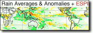
TRMM can be used to calibrate rainfall estimates from other satellites. The
TRMM-based, near-real time Multi-satellite Precipitation Analysis (TMPA) at
the NASA Goddard Space Flight Center is used to monitor rainfall over the global
Tropics. TMPA rainfall totals are shown here for the period 27 April to 8 May
2009, which captures the rainfall from both tropical cyclone events. The most
extreme rainfall totals, located over southern Luzon in the northeast-central
part of the islands are associated with then Tropical Storm Kujira and are on
the order of 900 mm or more (~36 inches, shown by the darker brown). The totals
from Chan-hom are considerably less on the order of 150 mm (~6 inches) and are
located over the northern part of Luzon (shown in green). The large difference
in rainfall between the two storms is due to the difference in their forward
motion and not their intensity--Kujira was only a tropical storm at the time
while Chan-hom was a typhoon.
|
Images by Hal Pierce(SSAI/NASA GSFC) and captions by Steve Lang (SSAI/NASA GSFC)
SEE EXTREME EVENTS ARCHIVES
|


(July 9, 2007) Google Earth Downloads
|


