Salt Lake City, Utah Area Flyover During Winter (NASM2002)
|
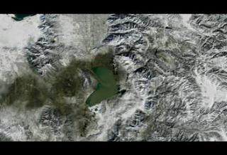
Landsat 7 imagery is combined here with terrain elevation data to create a view of the Salt Lake City area. This image was taken in the Winter of 2001 and can be compared to identical animations using images taken at other times of the year. This visualization was created for the NASM2002 presentation and is based on a earlier visualizations created for the 2002 Winter Olympics in Salt Lake City.
|
|
|
|
Winter 2001 Flyover of Salt Lake City, Utah
Duration: 4601.0 minutes
Available formats:
1280x720 (60 fps)
Frames
1280x720 (30 fps)
MPEG-2
339 MB
1280x720 (60 fps)
MPEG-2
180 MB
352x240 (30 fps)
MPEG-1
10 MB
320x218
JPEG
16 KB
320x218
JPEG
16 KB
720x480 (29.97 fps)
DV
291 MB
320x180 (60 fps)
MPEG-1
10 GB
320x180 (60 fps)
X-FLV
4 MB
How to play our movies
|
|

|
|
Winter 2001 in the Provo, Utah area
Available formats:
1280 x 720
TIFF
2 MB
160 x 80
PNG
30 KB
320 x 180
JPEG
13 KB
80 x 40
PNG
8 KB
|
|

|
|
Winter 2001 in the Provo, Utah area
Available formats:
1280 x 720
TIFF
2 MB
320 x 180
JPEG
20 KB
|
|

|
|
Winter 2001 in the Salt Lake City, Utah area
Available formats:
1280 x 720
TIFF
2 MB
320 x 180
JPEG
17 KB
|
|

|
|
Slate title from video tape reads, 'Salt Lake City, Utah. Winter 2001 from Landsat 7. Rendered in HD for NASM 2002.'
Available formats:
720 x 528
JPEG
148 KB
320 x 234
PNG
348 KB
|
|
|
Back to Top
|

