Great Zoom into Washington, DC: the U.S. Capitol
|
Using data from different spacecraft and some powerful computer technology, visualizers at the Goddard Space Flight Center present you with a collection of American cities in a way you have never seen them before. Starting with our camera high above the Earth, we rush in towards the surface at what would be an impossible speed for any known vehicle. Passing though layers of atmosphere, the colors of our destinations shimmer with their own unique characteristics, and suddenly we find ourselves floating in virtual space just above the ground.
|
|

|
|
A seamless zoom from space to the ground, using data from Terra-MODIS, Landsat-ETM+, and IKONOS, and ending at the U.S. Capitol in Washington, D.C.
Duration: 38.0 seconds
Available formats:
1280x720 (30 fps)
MPEG-4
23 MB
1280x720 (30 fps)
MPEG-2
84 MB
352x240 (29.97 fps)
MPEG-1
4 MB
320x240
JPEG
17 KB
160x80
PNG
26 KB
80x40
PNG
7 KB
1280x720 (30 fps)
Frames
320x180 (30 fps)
X-FLV
1 MB
How to play our movies
|
|

|
|
Full globe view
Available formats:
2560 x 1920
TIFF
3 MB
320 x 240
JPEG
6 KB
|
|
|
|
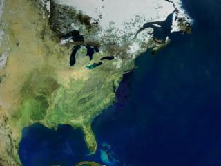
Eastern North America view
Available formats:
2560 x 1920
TIFF
7 MB
320 x 240
JPEG
11 KB
|
|
|
|
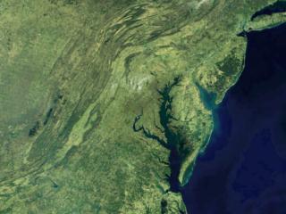
Mid-Atlantic view
Available formats:
2560 x 1920
TIFF
8 MB
320 x 240
JPEG
14 KB
|
|

|
|
Washington D.C. metro area view
Available formats:
2560 x 1920
TIFF
14 MB
320 x 240
JPEG
17 KB
|
|

|
|
Capitol and surrounding area view
Available formats:
2560 x 1920
TIFF
10 MB
320 x 240
JPEG
23 KB
|
|

|
|
U.S. Capitol
Available formats:
2560 x 1920
TIFF
5 MB
320 x 240
JPEG
17 KB
80 x 40
PNG
7 KB
160 x 80
PNG
26 KB
|
|
|
Back to Top
|

