| Home >> | Advanced Search >> |
|
|
|
Astronaut Photography of Earth - Display Record
STS108-717-85
Low-resolution Browse Image
(Most browse images are not color adjusted.)Images
Conditions for Use of Images >>Image Transformation Tutorial >> Saving, Color Adjusting, and Printing Images >>
Images to View on Your Computer Now
| File Name | File Size (bytes) | Width | Height | Annotated | Cropped | Purpose | Comments | |
|---|---|---|---|---|---|---|---|---|
| View | STS108-717-85.JPG | 30312 | 515 | 512 | No | No | From ISD Photo CDs | |
| View | STS108-717-85.JPG | 246841 | 540 | 453 | Yes | Yes | NASA's Earth Observatory web site | |
| View | STS108-717-85.JPG | 734647 | 1281 | 1257 | No | Yes | NASA's Earth Observatory web site | |
| View | STS108-717-85_2.JPG | 144379 | 400 | 335 | Yes | Photographic Highlights | ||
| View | STS108-717-85_3.JPG | 161065 | 600 | 589 | No | No |
Large Images to Request for Downloading
| File Name | File Size (bytes) | Width | Height | Annotated | Cropped | Purpose | Comments | |
|---|---|---|---|---|---|---|---|---|
| Request | STS108-717-85.JPG | 105435 | 1031 | 1024 | No | No | From ISD Photo CDs | |
| Request | STS108-717-85_2.JPG | 341358 | 2063 | 2048 | No | No | From ISD Photo CDs | |
| Request | STS108-717-85_3.JPG | 971092 | 4127 | 4096 | No | No | From ISD Photo CDs | |
| Request | STS108-717-85.JPG | 734647 | 1281 | 1257 | No | Photographic Highlights | ||
| Request | STS108-717-85_2.TIF | 2960612 | 1281 | 1257 | No | No | ||
| Request | STS108-717-85.TIF | 3572682 | 1305 | 1297 | No | No |
Download a Keyhole Markup Language (KML) file for use in Google Earth.
Electronic Image Data
Camera files only apply to electronic still cameras.No sound file available.
Identification
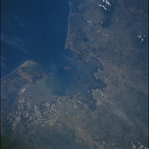
Mission: STS108 Roll: 717 Frame: 85 Mission ID on the Film or image: STS108Country or Geographic Name: NICARAGUA
Features: GULF OF FONSECA,MANGROVES, SEDIMENT
Center Point Latitude: 13.0 Center Point Longitude: -87.5 (Negative numbers indicate south for latitude and west for longitude)
Stereo: (Yes indicates there is an adjacent picture of the same area)
ONC Map ID: JNC Map ID:
Camera
Camera Tilt: 47Camera Focal Length: 110mm
Camera: HB: Hasselblad
Film: 5069 : Kodak Elite 100S, E6 Reversal, Replaces Lumiere, Warmer in tone vs. Lumiere.
Quality
Film Exposure:Percentage of Cloud Cover: 10 (0-10)
Nadir
Date: 20011213 (YYYYMMDD)GMT Time: 182704 (HHMMSS)Nadir Point Latitude: 9.3, Longitude: -86.8 (Negative numbers indicate south for latitude and west for longitude)
Nadir to Photo Center Direction: North
Sun Azimuth: 199 (Clockwise angle in degrees from north to the sun measured at the nadir point)
Spacecraft Altitude: 209 nautical miles (387 km)
Sun Elevation Angle: 56 (Angle in degrees between the horizon and the sun, measured at the nadir point)
Orbit Number: 124
Captions
For decades, astronauts on space missions have documented land use changes
around the world. In this pair of images, astronauts track the development of
shrimp farming along the Honduran coastline of the Gulf of Fonseca between 1989
and 2001. Mariculture, primarily shrimp farming, has become a leading
agricultural effort in Honduras. The regional transformation of large tracts of
coastal swamps into shrimp farms blossomed throughout the 1990s. The top image
was taken with color infrared film in 1989. Dense vegetation, like the coastal
mangrove swamps and the forested slopes of Volcán Cosigüina show up as dark red.
The bottom image, taken with color visible film by the crew of the most recent
Space Shuttle mission in December 2001 shows that hundreds of square kilometers
of coastal swamp, primarily in Honduras, have been converted to shrimp ponds.
These appear as the light-colored, rectilinear land use pattern. The Honduras
shrimp farms were hit hard by flooding after Hurricane Mitch in 1998, and a
devastating virus in 1999-2000. It is not known how many of the ponds in this
view are still functional. A vigorous debate continues about the sustainability
of the shrimp farms and the impacts to the environment and coastal ecosystem
due to mangrove clearing and mariculture waste production.
Apart from the shrimp farms, the other prominent feature on these images is
the impressive volcano Cosigüina, which erupted explosively in 1859 (the
largest recorded eruption in the Western Hemisphere).
Download Packaged File.
This option downloads the following items, packaged into a single file, if they are available:
- Browse image
- Cataloged information with captions
- Camera file
- Sound file
Server: 2 |
This service is provided by the International Space Station program. |
Recommended Citation: |
||

