

Thanks to new research from JPL, it is now easier to accurately track snowmelt -- water from snowpacks that melt in spring -- in mountainous regions.
Read more | Global Climate Change site
EARTH IMAGES from the JPL Photojournal
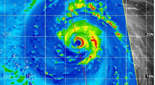
NASA satellite CloudSat captured an extraordinary eye overpass of a category 4 Hurricane Bill on August 19, 2009 at 1720 UTC (1220 EDT). Bill's maximum sustained winds are 132 mph (115 knots) with a central pressure of 947 mb.
Active Cavity Irradiance Monitor Satellite
Monitors total sun energy that reaches Earth.
› Instrument home page
Atmospheric Infrared Sounder on Aqua satellite
Measures air and surface temperature, clouds, humidity.
› Instrument home page
Microwave Limb Sounder on Aura satellite
Improves understanding of ozone and precursors.
› Mission home page
Tropospheric Emission Spectrometer on Aura satellite
Observes ozone and gases in the troposphere, the part of atmosphere where we live.
› Instrument home page
CloudSat
Revealing the inner secrets of clouds.
› Mission home page
Gravity Recovery and Climate Experiment
Measures Earth's gravitational field.
› Mission home page
Ocean Surface Topography Mission/Jason 2
A follow-on to Jason 1, this mission charts sea level, and its data will help improve climate and weather forecasts.
› Mission home page
Jason-1
Measures ocean level changes and El Niño.
› Mission home page
Quick Scatterometer
Measures ocean surface winds.
› Mission home page
Advanced Spaceborne Thermal Emission and Reflection Radiometer on Terra satellite
Takes high-resolution images, global and local.
› Instrument home page
Multi-angle Imaging Spectro-Radiometer on Terra satellite
Images Earth and aerosols from nine angles.
› Instrument home page
Shuttle Radar Topography Mission
Acquired the most complete near global mapping of Earth's topography.
› Mission home page

|
Seeing the Forest for the Trees
Mangroves are a vital but endangered natural resource in many coastal regions. A JPL researcher has completed the first full assessment of Africa's mangrove forests.
|

|
NASA's "A-Train" on Track With Hurricane Research
Whenever tropical cyclones are brewing, researchers around the world catch NASA's A-Train of Earth-monitoring satellites to learn more about them.
|

|
Your World, In Sharper Focus
New features in NASA's "Eyes on the Earth 3-D" online experience allow users to view the latest data -- some less than a few hours old-- from NASA Earth satellites.
|

|
Space Age Volcano Monitoring Network
If Mt. Saint Helens erupts again, a team of scientists and engineers will be monitoring with space age technology from NASA. |

|
What's Up for July?
Early astronomers like Galileo used telescopes to map the Milky Way galaxy. This month, you can see the Milky Way in the late evening. |

|
Cruising Over Los Angeles
Take a close-up tour of the L.A. area, courtesy of the space-based ASTER instrument. |