NOAA Technical
Memorandum NMFS-AFSC-88
Catch-per-Unit-Effort,
Length, and Depth Distributions of Major Groundfish and Bycatch Species in
the Bering Sea, Aleutian Islands and Gulf of Alaska Regions Based on
Groundfish Fishery Observer Data
by
Lowell W. Fritz, Angie Greig,
Rebecca Reuter
March 1998
Resource Ecology and
Fishery Management Division
Alaska Fisheries Science Center
7600 Sand Point Way NE
Seattle, WA 98115
U.S. DEPARTMENT OF
COMMERCE
William Daley, Secretary
National Oceanic and
Atmospheric Administration
D. James Baker, Administrator
National Marine Fisheries
Service
Rolland A. Schmitten, Assistant
Administrator for Fisheries
Contents
Abstract
Introduction
Methods
Results
and Discussion
Acknowledgments
Citations
Tables
Figures
Shape files
Return to REFM
Abstract
The identification and description
of essential fish habitat (EFH) for fish species managed under fishery
management plans (FMPs) is a requirement of the Magnuson-Stevens Fishery
Conservation and Management Act of 1996. Groundfish species off Alaska are
managed under two FMPs, one covering the Bering Sea-Aleutian Islands (BSAI)
region and another the Gulf of Alaska (GOA). This report summarizes data
collected by groundfish fishery observers from 1973-96 that may be useful
in the identification and description of EFH for adult and juvenile life
stages of groundfish and various species caught as bycatch.
Length-frequency and depth distributions of groundfish species in
commercial catches are provided in graphical form. As an index of relative
spatial distribution, groundfish catch-per-unit-effort (CPUE) is displayed
on a series of charts covering the BSAI and GOA regions.
Contents
Introduction
The Magnuson-Stevens Fishery
Conservation and Management Act (Act) of 1996 required the National Marine
Fisheries Service (NMFS) and regional fishery management councils to
describe and identify essential fish habitat (EFH) for species managed by
fishery management plans (FMPs). Essential fish habitat is defined in the
Act as "those waters and substrate necessary for spawning, breeding,
feeding, and growth to maturity" of fish, which is also
defined in the Act as "finfish, mollusks, crustaceans and all other
forms of marine animal and plant life other than marine mammals and
birds". The North Pacific Fishery Management Council (NPFMC) must
identify EFH off Alaska for each life stage (egg, larva, juvenile, and
adult) of each species managed under FMPs. The NPFMC administers five FMPs,
two of which are for groundfish in the Bering Sea and Aleutian Islands (BSAI)
region and the Gulf of Alaska (GOA). The other three FMPs are for BSAI
king and Tanner crab (Paralithodes spp., Lithodes spp.,
and Chionoecetes spp.) and Pacific salmon (Oncorhynchus
spp.) fisheries in the U.S. Exclusive Economic Zone (EEZ) off Alaska, and
scallop (Patinopectin caurinus, Chlamys spp., and Crassodoma
gigantea) fisheries off the coast of Alaska.
This report summarizes groundfish fishery
observer data to aid in the geographical description and identification of
EFH for species managed under the BSAI and GOA groundfish FMPs. Scientific
observers have been placed aboard commercial groundfish vessels fishing in
the BSAI and GOA regions since passage of the original Magnuson Fishery
Conservation and Management Act in 1976. Observers have collected large
amounts of a wide variety of data on fishery catches that are useful in
the EFH identification process for those species and life stages targeted
by fisheries or caught as bycatch.
This report displays in a series of graphs and
charts the length-frequencies, depth distributions, and relative
catches-per-unit-effort (CPUE) of groundfish species (Table 1) caught by
commercial fisheries from 1973 to 1996. The length-frequency data
summarizations show what life stages are caught by groundfish fisheries
off Alaska (principally adults with some juveniles), while the depth and
CPUE data reveal their relative spatial distributions.
Contents
Methods
Groundfish fishery observer data are
stored in two main databases: foreign and domestic. The foreign fishery
data, which also includes those data collected aboard joint-venture
vessels, were collected prior to 1991 when foreign nations were permitted
to fish for groundfish off Alaska. While the earliest data in the database
were collected in 1973, most of the data were collected between 1980 and
1987. Methods used by observers aboard foreign and joint-venture vessels
to collect catch data are described by Nelson et al. (1981). The domestic
groundfish fishery observer data were collected aboard U.S.-flagged
vessels according to the methods described by the NMFS (NMFS 1996). The
domestic data range in collection date from 1986 to the present. For this
analysis, data collected through 1996 are summarized.
Fishery observers collect many types of data on
commercial groundfish catches, including (but not limited to):
- Gear type used;
- Duration of haul, number of hooks or pots
deployed;
- Retrieval location of catch: latitude and
longitude to the nearest minute;
- Fishing depth of gear and bottom depth at the
location fished;
- Weights of individual species in samples of
the catch (extrapolated to the whole haul or gear set once data are
verified upon the observer's return); and
- Length-frequency of the target species.
Data summarized in this report consist of three
types: 1) fish length by species and gear type; 2) percent occurrence of
each species in catch composition samples taken at various depths by each
gear type; and 3) catch-per-unit-effort of each species by location and
gear type. Gear types used were trawls (which includes all types of
trawls, such as bottom, midwater (or pelagic), and pair trawls), longlines
(hook and line), and pots. From a random distribution of hauls, observers
obtain a random sample of the catch. Hauls for which species composition
has been estimated are termed "sampled hauls". The methods used
to summarize each data type are described below.
Length-frequency distributions were compiled by
species and dominant gear type for the combined BSAI-GOA regions and
foreign-domestic databases. Data are presented as both percent frequency
and cumulative percent frequency distributions by length.
The distribution of each species by depth was
analyzed by calculating the percent of sampled hauls within a certain
depth range that contained the species. The depth ranges used were in 50 m
intervals to 500 m, and in 100 m intervals to 1000 m. For some species,
data in several of the deepest ranges were accumulated in a single
"plus" group. Fishing depth was used to summarize depth
distributions of species caught by trawls, while bottom depth was used for
longlines and pots. For walleye pollock, which is caught principally by
midwater/pelagic trawls, there is a difference between fishing depth and
bottom depth. For all other species, which are caught primarily by bottom
trawls, longlines, or pots, fishing depth and bottom depth are identical.
Catch-per-unit-effort (CPUE) was summarized by
location and gear type to reveal patterns of relative density of each
species across all areas and times fished. The retrieval location of
sampled hauls is recorded in the observer database to the nearest minute
of latitude and longitude. Consequently, if the location of all sampled
hauls is plotted, a grid is formed with points spaced 1 nautical mile (nmi)
apart vertically (by latitude) and approximately 0.5 nmi apart
horizontally (by longitude). The average CPUE was calculated using
Equation (1),  where
W is the weight (in kg) of species or species group x in
sampled haul I taken at point p by gear type g,
E is the measure of effort (for trawl gear = hours trawled during
sampled haul I; longlines = number of hooks deployed divided by
100 in sampled haul I; pots = number of pots deployed in sampled
haul I) at point p for gear type g, and n
is the number of hauls of gear type g sampled at point p.
Species or species groups for which average CPUE at each sampled location
was calculated are listed in Table 1. For spatial analysis and display, 1
was added to the calculated average CPUE, and it was then rounded to the
nearest integer. where
W is the weight (in kg) of species or species group x in
sampled haul I taken at point p by gear type g,
E is the measure of effort (for trawl gear = hours trawled during
sampled haul I; longlines = number of hooks deployed divided by
100 in sampled haul I; pots = number of pots deployed in sampled
haul I) at point p for gear type g, and n
is the number of hauls of gear type g sampled at point p.
Species or species groups for which average CPUE at each sampled location
was calculated are listed in Table 1. For spatial analysis and display, 1
was added to the calculated average CPUE, and it was then rounded to the
nearest integer.
Some rudimentary spatial analysis of the CPUE
data was performed using ARC and ARCVIEW software from ESRI, Inc. First,
the data were gridded; a 1 km (on a side) square grid was placed over the
data and their attributes (e.g., CPUE, number of sampled hauls) were
assigned to individual grid cells. A grid size of 1 km2 was
chosen to ensure that no more than one sampled location fell within a
single grid cell. However, this also created many grid cells which had no
sampled locations within them.
Second, a neighborhood function was then applied
to the grid. For each 1 km2 grid cell, the maximum CPUE in the
5 cell by 5 cell (= 5 km X 5 km) neighborhood centered at the processing
cell was found and assigned to the new 25 km2 cell. This
process eliminated many of the empty cells (artificially created by the 1
km2 grid) and better represented the area over which the
sample(s) were taken than if the data were plotted as a single point at
the haul position; for these analyses, only haul retrieval position was
available and the actual area fished surrounded this point. For display,
each new 25 km2 cell was placed into one of four bins depending
on the CPUE value: 1) maximum average CPUE=0: no individuals of the
species had been found in sampled hauls taken in this cell; and 2) the
lower, middle, and upper thirds of the remaining non-zero CPUE values.
The 5 km X 5 km neighborhood function was
inappropriate to use to display the distribution of effort because the
neighborhood assessed moves one grid cell (in this case 1 km2)
at a time. If the sum of sampled hauls were computed in this manner,
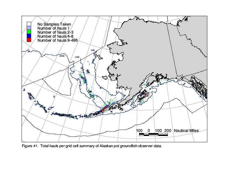
individual locations would be included as many as 9 times. Consequently, a
different method was used to display the spatial distribution of sampled
hauls. First, a 5 km X 5 km grid was constructed and a number was assigned
to each cell. Second, minute-by-minute effort data were assigned to each
grid cell based on their location, and the number of sampled hauls and
units of effort (hours, hooks, and pots) were summed within each cell. The
5 km X 5 km grid cells created for display of effort distribution do not
match those created to display each species' CPUE distribution (each of
which are different and reflect the relative distribution of each
species).
All maps of CPUE and effort distribution were
prepared using the Albers equal area conic projection with a reference
longitude of 154°W. The BSAI and GOA regions were each divided into two
sections for display on facing pages with only minimal overlap. The
western boundary of the GOA management region is actually at 170°W, but
the GOA region maps only extend to approximately 165°W. The area south of
the Aleutian Island archipelago from 165°W to 170°W which is in the GOA
management region is displayed on the BSAI charts.
Contents
Results and Discussion
Length-frequency distributions from the fishery
reveal that groundfish fisheries catch predominately adults and late
juveniles of targeted species, and that different gear types can have
different selectivities (Fig. 1). Most of the distributions are unimodal
and generally bell-shaped, including those for walleye pollock, yellowfin
sole, Pacific cod (all gear types), arrowtooth flounder, rock sole,
flathead sole, Dover sole, sablefish (longline), rex sole, Pacific ocean
perch, shortraker rockfish (longline) yelloweye rockfish (both gear
types), and Atka mackerel. Bimodal distributions were observed for
Greenland turbot (both trawls and longlines, but trawls caught smaller
fish), Alaska plaice, sablefish (trawl) and thornyhead rockfish. Some of
the rockfish length-frequency distributions were skewed, with the tails of
the distribution at either large (shortraker (trawl) and rougheye) or
small sizes (northern and dusky).
Percent frequency of occurrence of groundfish
species in sampled hauls taken within various depth ranges are shown in
Figure 2. Using these data, species can be grouped together (see below)
based on their frequency of occurrence in samples taken on the
inner-middle shelf (to depths of 100 m), outer shelf (100-200 m), upper
slope (200-500 m), and lower slope (500-1000 m). Many species are assigned
to more than one group if they were found in a broad range of depths in
commercial samples. These depth-range groups are based solely on
commercial sampling and represent only where the species have been
predominately caught by fisheries. As such, they may not represent the
actual distribution of most of the individuals of each species because of
the inability of the gear to be worked in some areas (due to untrawlable
rocky conditions), differences in the timing of fishing in an area and the
distribution of the fish, and various fishery management regulations.
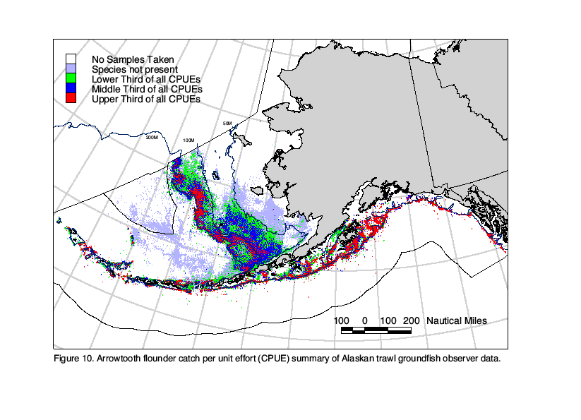
Examples of these discontinuities appear in the depth distributions for
arrowtooth flounder, which appears to be most prevalent on the inner shelf
but is actually more broadly distributed, and for Atka mackerel, which is
caught by the fishery primarily at depths between 100 and 200 m, but are
known to migrate to shallower waters to spawn in summer (Wolotira et al.
1993; Zolotov 1993).
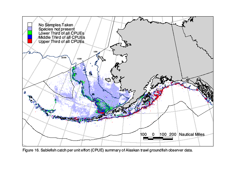
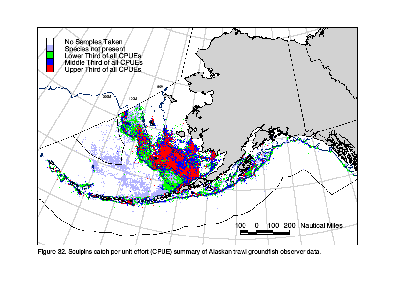
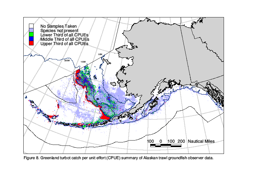
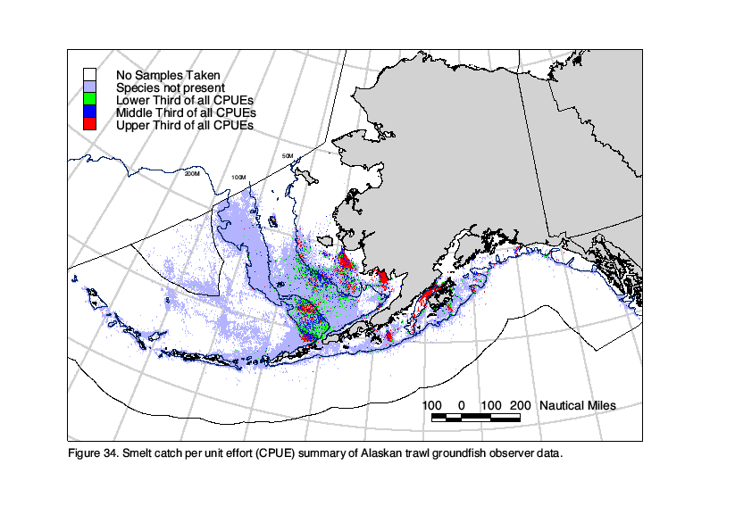
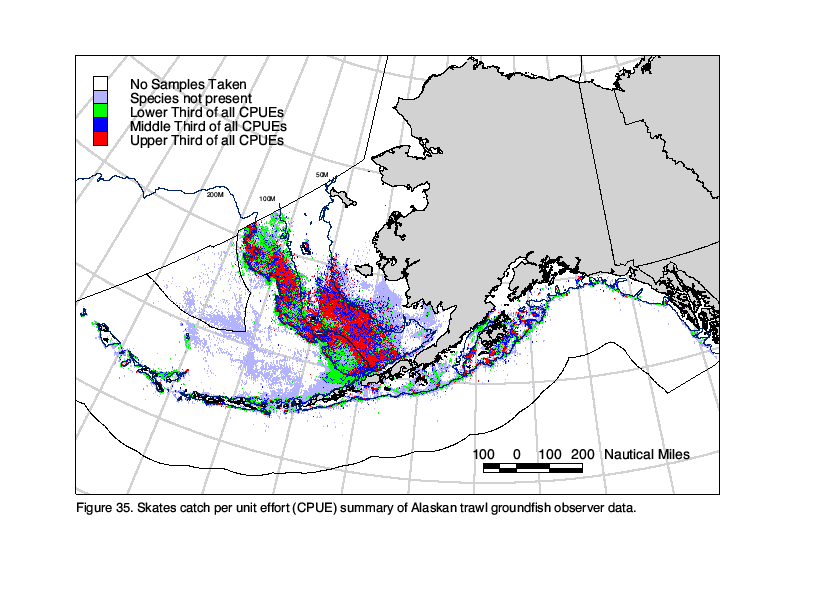
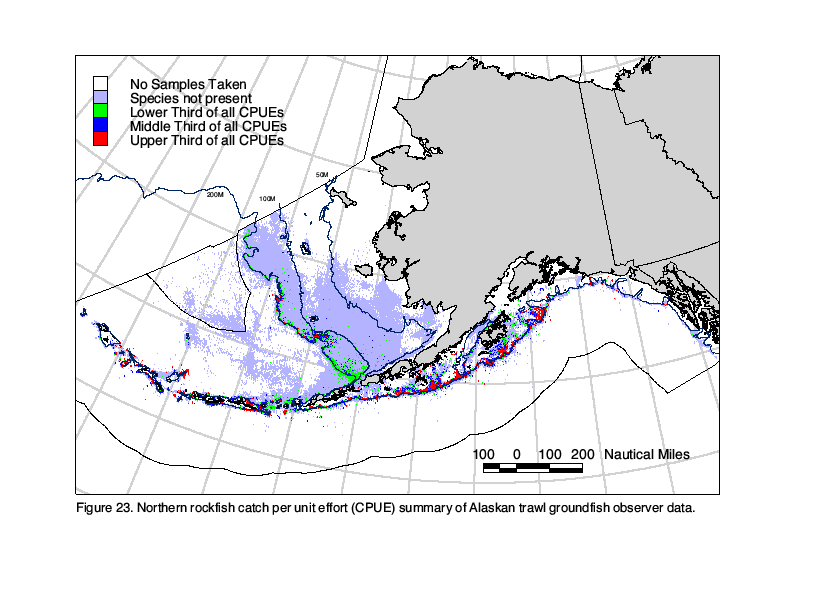
Spatial fishery CPUE distributions for each
species and gear type listed in Table 1 are shown in Figures 3-38. These
reveal not only the depth distributions shown in Figure 2, but also where
within the BSAI and GOA regions each species has appeared in fishery
samples, and the relative degree to which they have appeared. The size of
the fishery database summarized is detailed in Table 2 and the spatial
distribution of sampling effort is shown in Figures 39-41.
Several factors contribute to the results being
more heavily influenced by samples taken in the BSAI relative to the GOA.
First, there have been more hauls sampled within the BSAI than the GOA
region (Figs. 39-41), which reflects the relative sizes of the groundfish
catches within the two areas. Second, larger vessels, such as
catcher-processors capable of pulling large nets, have worked more
extensively in the BSAI region than in the GOA. Therefore, CPUEs in the
BSAI would likely be larger than in the GOA for the same species because
of the greater number of sampled hauls taken aboard large vessels. There
was no attempt to standardize CPUEs in this analysis to account for
differences in fishing power related to the size or power of each vessel
or the size and type of gear (e.g., type and mesh size of trawl); this may
be a valid criticism of the methods used in data summarization. Despite
these possible shortcomings, the distributions of species CPUE by
groundfish fisheries shown in Figures 3-38 are very similar to those for
adult and late juvenile fish appearing in charts prepared by Allen and
Smith (1988), NOAA's National Ocean Service (NOS 1988; 1990), and Wolotira
et al. (1993).
Fishery management regulations, particularly
those controlling when, where, and how much fish can be caught have
certainly affected the distribution of fisheries and as such, the
distributions of species' CPUE shown in Figures 3-38. One of these
restrictions, taken in 1987, was the permanent closure of North Pacific
Fishery Management Council Area 512 in the southeastern Bering Sea to
trawling to protect spawning aggregations of red king crab (Witherell and
Pautzke 1997). Area 512 is located south of 58°N between 160°W and 162°W.
The result of this closure is a lack of sampled fishery haul locations in
this area, resulting in straight line edges in the distribution of sampled
hauls. Similarly, Area 518 was closed to directed walleye pollock fishing
beginning in 1992 to protect spawning aggregations of the Aleutian Basin
walleye pollock stock (Fritz et al. 1995). Area 518 is located between 167°W
and 170°W north of the Aleutian Islands and south of the 200 m isobath.
Total allowable catch quotas for walleye pollock, among other groundfish,
are allocated separately to the Aleutian Islands district (located west of
170°W and south of 55°N to the edge of the Exclusize Economic Zone, 200
miles south of the Aleutian Island archipelago) and eastern Bering sea
districts. As a result of separate spatial walleye pollock quotas and the
closure of Area 518, pelagic trawl effort in deep Aleutian Basin waters
north of the archipelago stops abruptly at 170°W. These two area closures
are only two examples of how regulations affect both the distributions of
fisheries and their CPUEs as shown in Figures 3-38. More detailed
summaries of the regulatory history of North Pacific groundfish fishery
management are available in Fredin (1987), Witherell and Roberts (1996),
Witherell and Pautzke (1997), and Witherell (1997).
The maps of fishery CPUE distribution by species
presented in this report are useful in describing where the fishery has
been successful in catching adult groundfish. However, as discussed above,
there are many factors that influence the distribution of fisheries that
may be independent of the distribution of adults of the target species.
Therefore, the maps in this report should be used in conjunction with
other reference materials and data to determine the areal extent of EFH
for adult groundfish as required under the Act.
Contents
Acknowledgments
We thank the following people for
their assistance in this project: Frank Pfeiffer developed methods and
functions for quickly accessing all of the observer data; Jerry Berger and
others in the AFSC Observer Program made the foreign data available in
time for inclusion in this report; Kathleen Hurlbert and Brenda Shiraki
assisted in data acquisition and storage; the members of the Alaska Region
Essential Fish Habitat core team (Matt Eagleton, Tamra Faris, Jeff
Fujioka, Cindy Hartmann, Jeff Short, and Dave Witherell) for their
suggestions during the project; and Gary Duker, James Lee, Martin Loefflad,
Gary Walters, and Thomas Wilderbuer for their comments on the manuscript.
Contents
Citations
Allen, M. J., and G. B. Smith. 1988.
Atlas and zoogeography of common fishes in the Bering Sea and northeastern
Pacific. U.S. Dep. Commer., NOAA Tech. Rep. NMFS 66, 151 p.
Fredin, R. A. 1987. History of regulation of
Alaska groundfish fisheries. NWAFC Processed Rep. 87-07, 63 p. Alaska
Fisheries Science Center, Natl. Mar. Fish. Serv., NOAA, 7600 Sand Point
Way NE, Seattle, WA 98115-0070.
Fritz, L. W., R. C. Ferrero, and R. J. Berg.
1995. The threatened status of Steller sea lions, Eumetopias jubatus,
under the Endangered Species Act: Effects on Alaska groundfish fisheries
management. Mar. Fish. Rev. 57(2): 14-27.
Nelson, R., Jr., R. French, and J. Wall. 1981.
Sampling by U.S. observers on foreign fishing vessels in the eastern
Bering Sea and Aleutian Island region, 1977-78. Mar. Fish. Rev. 43(5):
1-19.
NMFS. 1996. Manual for biologists aboard domestic
groundfish vessels. Available from: U.S. Dep. Commer., NOAA, NMFS, Alaska
Fisheries Science Center, 7600 Sand Point Way, NE, Seattle, WA 98115. 431
p.
NOS. 1988. Bering, Chukchi, and Beaufort Seas.
Coastal and Ocean Zones Strategic Assessment: Data Atlas. U.S. Dep. Commer.,
NOAA, NOS, Office of Ocean Resources Conservation and Assessments,
Strategic Environmental Assessments Div., SSMC4, 1305 East-West Highway,
Silver Spring, MD 20910.
NOS. 1990. West Coast of North America. Coastal
and Ocean Zones Strategic Assessment: Data Atlas. U.S. Dep. Commer., NOAA,
NOS, Office of Ocean Resources Conservation and Assessments, Strategic
Environmental Assessments Div., SSMC4, 1305 East-West Highway, Silver
Spring, MD 20910.
Witherell, D. 1997. Summary of the Bering Sea and
Aleutian Islands groundfish fishery management plan. North Pacific Fishery
Management Council, 605 W. 4th Ave., Suite 306, Anchorage, AK 99501. 16 p.
Witherell, D., and C. Pautzke. 1997. A brief
history of bycatch management measures for eastern Bering Sea groundfish
fisheries. North Pacific Fishery Management Council, 605 W. 4th Ave.,
Suite 306, Anchorage, AK 99501. 11 p.
Witherell, D., and L. Roberts. 1996. Regulatory
and closure areas for the groundfish fisheries in the Bering Sea and
Aleutian Islands. North Pacific Fishery Management Council, 605 W. 4th
Ave., Suite 306, Anchorage, AK 99501. 17 p.
Wolotira, R. J., T. M. Sample, S. F. Noel, and C.
R. Iten. 1993. Geographic and bathymetric distributions of many
commercially important fishes and shellfishes off the west coast of North
America, based on research survey and commercial catch data, 1912-84. U.S.
Dep. Commer., NOAA Tech. Memo. NMFS-AFSC-6, 184 p.
Zolotov, O. G. 1993. Notes on the reproductive
biology of Pleurogrammus monopterygius in Kamchatkan waters.
Journ. Ichthyol. 33(4): 25-37.
Table 1.--List of species and gear types for
which groundfish fishery observer data were summarized.
|
|
|
Gear Type
|
|
Species or Group
|
Scientific Name
|
Trawl
|
Longline
|
Pot
|
| Walleye pollock |
Theragra chalcogramma |
X |
|
|
| Pacific cod |
Gadus macrocephalus |
X |
X |
X |
| Yellowfin sole |
Pleuronectes (=Limanda)
asper |
X |
|
|
| Greenland turbot |
Reinhardtius
hippoglossoides |
X |
X |
|
| Arrowtooth flounder |
Atheresthes stomias,
A. evermanni |
X |
|
|
| Rock sole |
Pleuronectes bilineatus |
X |
|
|
| Alaska plaice |
Pleuronectes
quadrituberculatus |
X |
|
|
| Dover sole |
Microstomus pacificus |
X |
|
|
| Rex sole |
Errex zachirus |
X |
|
|
| Flathead sole |
Hippoglossoides
elassodon |
X |
|
|
| Sablefish |
Anoplopoma fimbria |
X |
X |
|
| Pacific ocean perch |
Sebastes alutus |
X |
|
|
| Shortraker rockfish |
Sebastes borealis |
X |
X |
|
| Rougheye rockfish |
Sebastes aleutianus |
X |
X |
|
| Northern rockfish |
Sebastes polyspinus |
X |
|
|
| Dusky rockfish |
Sebastes ciliatus |
X |
|
|
| Yelloweye rockfish |
Sebastes ruberrimus |
X |
X |
|
| Thornyhead rockfish |
Sebastolobus alascanus,
S. macrochir, S. altivelis |
X |
|
|
| Atka mackerel |
Pleurogrammus
monopterygius |
X |
|
|
| Squid spp. |
Decapoda, Moroteuthis
robusta |
X |
|
|
| Octopus spp. |
Octopoda, Vampyromorpha |
X |
|
X |
| Sculpin spp. |
Cottidae |
X |
X |
|
| Smelt spp. |
Osmeridae |
X |
|
|
| Skate spp. |
Rajidae |
X |
X |
|
| Shark spp. |
Squaliformes |
X |
X |
|
Table 2.--Statistical summary of groundfish fishery observer data
collected from 1973 to 1996 and summarized in this report.
A. Locations (minute latitude by minute
longitude) Sampled by Observers
| Gear
Type |
Number
of Locations Sampled |
Number
of Hauls Sampled |
Number
(and %) of Locations with: |
Sampled
Effort |
B. Within 5 km X 5 km Grid Cells
| Gear
Type |
Number
of Grid Cells Sampled |
Number
of Hauls Sampled |
Number
(and %) of Cells with: |
Sampled
Effort |
| All
Cells |
Range
Within
Each Cell |
1
Sampled Haul |
2
Sampled Hauls |
3+
Sampled Hauls |
All
Cells |
Range
Within Each Cell |
| Trawl |
28,752 |
428,893 |
1 - 1,022 |
6,623
(23%) |
3,180
(11%) |
18,949
(66%) |
1,614,570
hours |
0.05
- 5,607
hours |
| Longline |
12,240 |
81,178 |
1 - 132 |
4,059
(33%) |
1,942
(16%) |
6,239
(51%) |
880,279,900
hooks |
1
- 1,222,600
hooks |
| Pot |
3,405 |
21,038 |
1 - 496 |
1,311
(38%) |
511
(15%) |
1,583
(47%) |
1,458,705
pots |
1
- 14,314 pots |
Contents
Figures
Contents
Shape files
Map layer information is also available to you
here as zipped "shape" files a format use by ArcView software
produced by Environmental Systems Research Institute, Inc..
Download free viewing software (ArcExplorer) from
http://www.esri.com.
The shape files are in an Albers equal area
projection. Units = meters, 1st standard parallel = 55, 2nd
standard parallel = 65, central meridian = -154, latitude of projections
origin = 60. The variable field "cpue" has values of:
"high", "med", "low", "none" which
can be assigned different colors to show the distribution of the species
group.
Individual species shape files for down load
Walleye pollock
Pacific cod Yellowfin
sole Greenland turbot
Arrowtooth flounder Rock
sole Alaska plaice
Dover sole Rex
sole Flathead sole
Sablefish Pacific
ocean perch Shortraker
rockfish Rougheye
rockfish Northern rockfish
Dusky rockfish Yelloweye
rockfish Thornyhead
rockfish Atka mackerel
Squid Octopus
Sculpin Smelt
Skate Shark
Effort shape files for down load Trawl
effort Longline
effort Pot
(trap fishing) effort
Coastline, lat-lon, and bathymetry shape files
for down load Alaska coast
Latitude, Longitude
Bathymetry
|
