Post Date: 27 April 2008
Nome, AK
Latitude: 64° 30.000'N
Longitude: 165° 23.000'W
Posted By: Michael Cameron
Homeward Bound
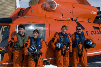
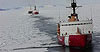
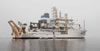
We stayed up late into the night packing our gear, backing up the data and tying up all of the hundreds of loose ends. Properly preparing and planning for a cruise is critical to its success and can take a lot of time. Wrapping one up is just as important and is also a lengthy process. We finished close to 3 AM which gave us just a few hours to sleep before our departure later that morning. Despite running on turbines for most of the night, we woke to find that the heavy ice had slowed our progress. We were still 45 miles south of Nome. Close enough for a helicopter but too far (and too much ice) for a small boat. So, after thanking the captain and crew for a terrific cruise, we boarded the helicopter one last time for a ride to Nome. We landed at the airport right in front of an Alaska Airlines 737; our airplane back to Anchorage. The Alaska Airlines pilot slid open his window and, leaning over his elbow, poked his head out to give us a
friendly "Welcome aboard!"
Despite the weather delays, we still had a great field season and we will be analyzing the sightings data for the next few years. We were originally promised seven days in which to conduct our work, but with all of the fog we experienced at the ice edge it looked possible that we might only fly a few times. Thankfully, the Coast Guard and the captain were able to find more
time in their busy schedule and extended our survey period an extra four days. Such a change in schedule is virtually unheard of on any ship, but it was just one of the many ways that the command and crew of the Polar Sea and aviation departments went out of their way to help ensure our success. So "Thank you" Polar Sea! We hope to join you again next year.
More from the Polar Sea survey>>>