Archive of Features About the Yellowstone Volcanic System
2009
Listen to a podcast about the recent swarm. Dr. Jake Lowenstern, YVO Scientist-In-Charge, tells us what's happening and how scientists monitor volcano and earthquake activity at Yellowstone.
2008
The University of Utah Seismograph Stations reports that a notable swarm of earthquakes has been underway since December 26 beneath Yellowstone Lake in Yellowstone National Park, three to six miles south-southeast of Fishing Bridge, Wyoming. This energetic sequence of events was most intense on December 27, when the largest number of events of magnitude 3 and larger occurred. More...
The University of Utah Seismograph Stations reports that a swarm of small earthquakes of magnitude 3.5 and smaller is occurring beneath Yellowstone Lake in Yellowstone National Park, five to nine miles south-southeast of Fishing Bridge, Wyoming. The swarm began yesterday afternoon, Dec. 26, and has continued and intensified today. More...
The Yellowstone Volcano Observatory is the first of the Volcano Hazards Program (VHP)
observatories to adopt the new VHP navigation and template. The new template aims to
make it easier to find content on the VHP site and several of the VHP observatory sites.

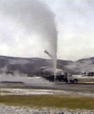
New research suggests that how often Old Faithful and other Yellowstone geysers erupt may depend on annual rainfall patterns. USGS scientist Shaul Hurwitz along with colleagues at Stanford and Yellowstone National Park have discovered that changes of water supply to a geyser's underground plumbing may have a large influence on eruption intervals; that is, the time between eruptions. For example, geysers appear to lengthen and shorten their intervals on cycles that mimic annual dry and wet periods. The study results were published in the article, Climate-induced variations of geyser periodicity in Yellowstone National Park, USA, in the June issue of the journal Geology.
Geysers are rare hot springs that periodically erupt bursts of steam and hot water. Yellowstone National Park has more than half of the world's geysers. Old Faithful has remained faithful for at least the past 135 years, showering appreciative tourists every 50 to 95 minutes (most recently an annual average of 91 minutes). To view Old Faithful in real-time, see the National Park Service Old Faithful Webcam.
The University of Utah Seismograph Stations reports that a light earthquake
of magnitude 4.1 occurred at 05:59 AM on March 25, 2008 (MDT) in
Yellowstone National Park. The epicenter of the shock was located 29.8 km
(18.6 mi) NE of Fishing Bridge, WY. Two earthquakes of magnitude 3.0 or
greater have occurred within 25 km of the epicenter of this event since
1962. The largest of these events was a magnitude 3.5 on July 20, 1992,
6.4 km (4.0 mi) NE of Fishing Bridge, WY. No earthquakes of magnitude 4.5
or greater have occurred within 50 km of the epicenter of this event since
1962. This event has been reported felt in Pahaska Tepee, outside the east
entrance to Yellowstone National Park and in southwest Montana as well as
in western Wyoming.
In the 1960's, USGS researchers drilled
research wells to learn about the Yellowstone geothermal system.
One of those wells, the Y8 at Biscuit Basin, started leaking
in 1992, and was immediately capped and plugged by the USGS,
the National Park Service, and a local drilling company.
Because of its historic and scientific interest, a video of
the operation was recently reformatted and published as USGS
Open-File Report 2008-1014, which can be downloaded in a
variety of formats. The video can also be streamed
to your computer without downloading. Enjoy!
2007
USGS scientists and their collaborators recently published a compendium of research papers about Yellowstone National Park. USGS Professional Paper 1717 is entitled: Integrated Geoscience Studies in the Greater Yellowstone Area - Volcanic, Tectonic, and Hydrothermal Processes in the Yellowstone Geoecosystem. The sixteen chapters include studies of geology, geochemistry and geophysics, including several with a focus on Yellowstone Lake. A separate map entitled: Bathymetry and Geology of the Floor of Yellowstone Lake, Yellowstone National Park, Wyoming, Idaho, and Montana, was also recently published.

The November 9, 2007 issue of Science Magazine features an article, Accelerated uplift and magmatic intrusion of the Yellowstone Caldera, 2004 to 2006, by YVO scientists from the University of Utah and USGS. Using GPS and another satellite-based technique (InSAR), the authors find that parts of the Yellowstone Caldera rose as much as 7 cm (~3") per year from 2004 to 2006. The uplift is most noticeable at the White Lake GPS station, as has been discussed in our monthly YVO updates over the past year. Chang and his colleagues credit the relatively rapid uplift to magma entering the region beneath the Yellowstone Caldera. During this period of uplift, there have been relatively few earthquakes at Yellowstone. Heat and gas flow from the geysers and hot springs also remain unchanged. Calderas such as Yellowstone can display this sort of geologic behavior, even for centuries or millennia, without erupting. Read more about the uplift in our article Recent ups and downs of the Yellowstone Caldera. Also see the University of Utah press release.
Yellowstone Volcano Observatory (YVO)
just released a Preliminary
Assessment of Volcanic and Hydrothermal Hazards in Yellowstone National
Park and Vicinity. The assessment, four years in the making,
is authored by Robert Christiansen, a leading expert on the Yellowstone
volcanic
system, along with eight colleagues. The preliminary assessment has
been published as an Open-File Report. Over
the next 2 years, the assessment will be enlarged to include a seismic
hazards analysis and other additional enhancements. At that point, the
hazards assessment will be released as a more formal USGS Scientific
Investigations Report that will replace this preliminary report.
03/08/2007
University of Utah graduate student
Christine
Puskas, along with YVO coordinating scientist Bob Smith and others,
recently published a long-term study of crustal movements associated
with the Yellowstone hotspot. This technical article summarizes 17
years of Global Positioning System (GPS) data acquired to understand
how the Yellowstone volcano and the Snake River Plain volcanic field
interacts with the nearby Teton and Hebgen Lake faults and the tectonic
system of the Western U.S. The original paper, published in the Journal
of Geophysical Research, can
be downloaded here (downloadable pdf is 3470 KB). The
research is described for a general audience in a press
release by the University of Utah.
New articles focus on the geology and
thermal activity of the Norris Geyser Basin
03/08/2007
The Fall 2006 issue of Yellowstone
Science includes two articles on the Norris Geyser Basin. The
first article
(downloadable pdf is 1380KB), by Yellowstone National Park geologist
Cheryl Jaworowski and co-authors, relates how natural fractures are a
crucial control on the distribution and behavior of thermal features at
Norris. The
second article
(downloadable pdf is 700KB), by Geological Society of America intern
David Shean, uses historical aerial photographs as a tool to detect
changes in thermal activity at Norris. Both articles can be downloaded
off the Yellowstone Science website.
In September 2005, USGS/YVO
Postdoctoral Fellow Brita Graham Wall used a
radio-controlled camera, attached to a helium-filled balloon to take
photos from the sky above the Norris Geyser Basin. Some of the photos
are truly
spectacular, and we hope you enjoy them.
Please see the images in the article Way
Above Norris.
University of
Utah scientists publish long-term study of crustal motions of the
Yellowstone Hotspot
2006
Yellowstone Volcano Observatory (YVO)
has developed a monitoring plan for the period 2006-2015 to increase
our ability to provide timely information during seismic, volcanic, and
hydrothermal crises and to anticipate hazardous events before they
occur. Upgrades to the monitoring network will provide high-quality
data for scientific study and interpretation of one of the largest
active volcanic systems in the world. Equipment additions and upgrades
will bring the seismic network up to modern standards and add stations
in areas that lack adequate station coverage. Borehole strainmeters and
tiltmeters will be added to measure crustal movements and stream gages
and gas-measuring instruments will allow YVO to compare geophysical
phenomena, such as earthquakes and ground motions, to hydrothermal
events, such as anomalous water and gas discharge. Please see the Volcano and
Earthquake Monitoring Plan for the Yellowstone Volcano Observatory,
2006-2015 for more information.
Images from the Yellowstone Volcano
Observatory photogallery are now available as a kml file! To check out
the images in their geographic locations, download the kml file and click on it
to open it in Google Earth. If you do not already have a copy of Google
Earth, visit http://earth.google.com/
to download a copy. Thanks to John Bailey of the Alaska Volcano
Observatory & Arctic Region Supercomputing Center for creating
the file.
YVO coordinating scientists Jacob
Lowenstern and Robert Smith together with Long Valley
Scientist-in-Charge David Hill recently published an article, Monitoring
super-volcanoes: geophysical and geochemical signals at Yellowstone and
other large caldera systems", that summarizes current
knowledge about monitoring geological unrest at large calderas such as
Yellowstone. The article is part of a group of papers that formed a
Discussion Meeting on Extreme Natural Hazards organized through the
Royal Society in October 2005. For more information about other papers
from the meeting, please see the
Phil. Trans. R. Soc. A Web site.
The American Museum of Natural History
joined Yellowstone Volcano Observatory scientists in the field last
September (2005) and have just posted a video, articles, and two
interactive slide shows about the geology of the area. The video, Yellowstone:
Monitoring the Fire Below includes interviews with Jake
Lowenstern, YVO's Scientist-in-Charge, Hank Heasler, YVO Coordinating
Scientist and Yellowstone Park Geologist, and USGS geologist Lisa
Morgan. The articles, Yellowstone
National Park is a Volcano and Signs
of Restlessness expand on the information in the
video whereas the article, Volcanic
Witness: An Interview with Bob Smith provides
information from Bob Smith's, YVO's Coordinating Scientist from the
University of Utah, four decades of work on Yellowstone. For more
information and to view the video, please see American
Museum of Natural History Science Bulletins, Yellowstone: Monitoring
the Fire Below.
The U.S. Geological Survey (USGS) is
adopting a common system nationwide for characterizing the level of
unrest and eruptive activity at volcanoes. YVO is the first volcano
observatory to implement the new standard alert-level system. Our
Monthly Updates, Status Reports, and Information Releases will now
include both an alert level and an aviation color code. Yellowstone is
currently at the alert level, NORMAL (Typical background activity of a
volcano in a non-eruptive state), and Aviation Color Code GREEN
(Volcano is in normal, non-eruptive state.). For more information,
please see the article on the Volcano Hazards Website "USGS to Adopt a
Common Alert-Level System to Inform Public of Volcanic Activity at U.S.
Volcanoes".
This March 2006, the journal Nature published a
paper by YVO scientist Charles Wicks and colleagues about a period of
uplift in the northern part of the Yellowstone caldera. For more
information about the recent findings, please see Satellite
Technologies Detect Uplift in the Yellowstone Caldera.
A new website
devoted to Yellowstone geologic data has just been launched
by YVO coordinating scientist Bob Smith and University of Utah graduate
student Jamie Farrell, with support from the National Science
Foundation's GEON
program. The site provides a variety of maps, figures and GIS
(geographic information system) datasets of interest to both scientists
and the general public.
2005
The June 2005 issue of Geotimes
magazine includes an article by YVO Scientist-in-Charge Jake
Lowenstern. The article, Truth,
fiction and everything in between at Yellowstone, presents
Lowenstern's views on public and media interest in Yellowstone and its
volcanic potential.
On April 29, 2005, The U.S. Geological
Survey (USGS) released the first ever comprehensive and systematic
review of all 169 volcanoes in the United States. The report, An Assessment of
Volcanic Threat and Monitoring Capabilities in the United States:
Framework for a National Volcano Early Warning System,
establishes a framework for a National Volcano Early Warning System
(NVEWS), "which calls for a 24-hour seven-day-a-week Volcano Watch
Office and enhanced instrumentation and monitoring at targeted
volcanoes". Each of the 169 volcanoes were divided into five threat
groups: Very High, High, Moderate, Low, and Very Low. The USGS
press release on NVEWS summarizes the 37 volcanoes in the
Very High threat group and mentions an additional 21 under-monitored
volcanoes. Yellowstone is one of the 21 under-monitored volcanoes in
the High threat group. This does not mean that the geologic
conditions at Yellowstone have changed. The activity at
Yellowstone remains consistent with historical levels.
BBC
and the Discovery
Channel produced a new docudrama and documentary about
Yellowstone. For more information on the docudrama and documentary see
our docudrama question and answer page.
Yellowstone has experienced several
giant volcanic eruptions in the past few million years, as well as many
smaller eruptions and steam explosions. To improve our understanding of
the volcanic, seismic, and hydrothermal hazards, scientists study and
monitor activity at Yellowstone. Check out our new fact sheet that
describes Yellowstone's past and potential future activity.
2004
In April 2004 there was an increase in
earthquake activity, called a swarm, at Yellowstone National Park that
drew interest from scientists and the public. Swarms can occur on
volcanoes or in tectonically active areas. There have been many swarms
recorded over the past 40 years at Yellowstone. For more information
see the Earthquake
Swarms at Yellowstone article.
Over the past ten years scientists have
been applying new satellite-based surveying techniques to monitor
changes in the land surface elevation within Yellowstone Caldera. These
new measurements add to monitoring data collected over the past 25
years and help increase our understanding of the slow up and down
ground movements of the Yellowstone caldera above the subterranean
magma and hydrothermal systems. For more information see the Tracking Changes in
Yellowstone's Restless Volcanic System fact sheet.
Yellowstone
National Park Opens new Back Basin Boardwalk
08/02/2004
On August 2, 2004, a new boardwalk
opened in the Norris Geyser Basin. The new route reopened access
through the Back Basin area.
Yellowstone
Park Biologists Discover Five Dead Bison
03/10/2004
On March 10, 2004, Yellowstone Park
biologists discovered 5 dead bison along the Gibbon River near Norris
geyser basin. The bison appeared to have died about one week earlier
due to inhalation of toxic geothermal gases. The gases, most probably CO2
and/or H2S, likely accumulated in a low area due
to very cold windless conditions. Though such events are rare, over the
Park's 132-year history similar animal kills have occurred several
times. Visitors can safely view Yellowstone's thermal areas by staying
on designated trails and boardwalks.
In 2003, articles in the press reported
a "bulge" beneathYellowstone Lake that generated some concern about
possible dangers for residents or visitors to the area. Click
herefor answers to some of the questions we were asked by the
public and press.
2003
There were were notable changes in
thermal activity at Norris Geyser Basin in 2003. These changesresulted
in the closure of the Back Basin Trail and temporarydeployment of a
monitoring network by YVO. Learn
more.
On October 9, 2003, portions of Norris
Geyser Basin reopened to the public. Read the National
Park ServiceNews Release.