| Home >> | Advanced Search >> |
|
|
|
Astronaut Photography of Earth - Display Record
STS103-729-63
Low-resolution Browse Image
(Most browse images are not color adjusted.)Images
Conditions for Use of Images >>Image Transformation Tutorial >> Saving, Color Adjusting, and Printing Images >>
Images to View on Your Computer Now
| File Name | File Size (bytes) | Width | Height | Annotated | Cropped | Purpose | Comments | |
|---|---|---|---|---|---|---|---|---|
| View | STS103-729-63.JPG | 16187 | 515 | 512 | No | No | From ISD PhotoCDs | |
| View | STS103-729-63.JPG | 196116 | 540 | 380 | Yes | Yes | NASA's Earth Observatory web site | |
| View | STS103-729-63.JPG | 113587 | 400 | 280 | Yes | Yes | Photographic Highlights |
Large Images to Request for Downloading
| File Name | File Size (bytes) | Width | Height | Annotated | Cropped | Purpose | Comments | |
|---|---|---|---|---|---|---|---|---|
| Request | STS103-729-63.JPG | 74709 | 1031 | 1024 | No | No | From ISD PhotoCDs | |
| Request | STS103-729-63_2.JPG | 371112 | 2063 | 2048 | No | No | From ISD PhotoCDs | |
| Request | STS103-729-63_3.JPG | 1271900 | 4127 | 4096 | No | No | From ISD PhotoCDs |
Download a Keyhole Markup Language (KML) file for use in Google Earth.
Electronic Image Data
Camera files only apply to electronic still cameras.No sound file available.
Identification
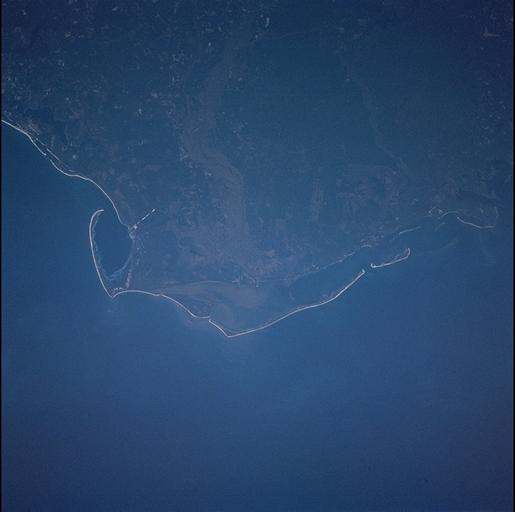
Mission: STS103 Roll: 729 Frame: 63 Mission ID on the Film or image: STS103Country or Geographic Name: USA-FLORIDA
Features: APALACHICOLA RIVER DELTA
Center Point Latitude: 30.0 Center Point Longitude: -85.0 (Negative numbers indicate south for latitude and west for longitude)
Stereo: (Yes indicates there is an adjacent picture of the same area)
ONC Map ID: JNC Map ID:
Camera
Camera Tilt: 24Camera Focal Length: 250mm
Camera: HB: Hasselblad
Film: 5069 : Kodak Elite 100S, E6 Reversal, Replaces Lumiere, Warmer in tone vs. Lumiere.
Quality
Film Exposure:Percentage of Cloud Cover: 10 (0-10)
Nadir
Date: 19991226 (YYYYMMDD)GMT Time: 220152 (HHMMSS)Nadir Point Latitude: 28.0, Longitude: -86.1 (Negative numbers indicate south for latitude and west for longitude)
Nadir to Photo Center Direction: Northeast
Sun Azimuth: 237 (Clockwise angle in degrees from north to the sun measured at the nadir point)
Spacecraft Altitude: 301 nautical miles (557 km)
Sun Elevation Angle: 10 (Angle in degrees between the horizon and the sun, measured at the nadir point)
Orbit Number: 104
Captions
Sediments from the Apalachicola River delta complex form islands of sand ridges (cheniers). During high flow, the river delivers abundant sediment to the delta; as flow wanes the stream drops its load of coarser material around the channel mouth, to be redistributed primarily by waves. Variations in sediment supply and wave energy result in alternating bands of sand and mud. To see more detail of cheniers see St. Vincent Island, STS102-349-35.Link to Earth Observatory Caption >>
Download Packaged File.
This option downloads the following items, packaged into a single file, if they are available:
- Browse image
- Cataloged information with captions
- Camera file
- Sound file
Server: 2 |
This service is provided by the International Space Station program. |
Recommended Citation: |
||

