|
About Us
The California-Nevada River Forecast Center (CNRFC)
is a field office of the National Weather Service (NWS) located
in Sacramento, California. The NWS is an agency of the National
Oceanic Atmospheric and Administration (NOAA) under the United States
Department of Commerce.
This mission of the NWS Hydrologic Services Program
is to:
- Provide river and flood forecasts and warnings
for the protection of lives and property.
- Provide basic hydrologic forecast information for the nation’s
environmental and economic well being.
The NWS accomplishes its mission through 125 Weather
Forecast Offices (WFOs), 13 River Forecast Centers (RFCs), and 5
National Centers for environmental Prediction (NCEP). These field
offices are administratively and technically supported by Regional
and National headquarters.
The NWS River Forecast Centers have four basic functions:
- Continuous hydrometeorological data assimilation,
river basin modeling, and hydrologic forecast preparation.
- Technical support and interaction with supported and supporting
NWS offices.
- Technical support and interaction with outside water management
agencies and users.
- Applied research, development, and technological implementation
to facilitate and support the above functions.
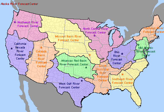
Figure 1 - Map of River Forecast Centers
The hydrologic area of responsibility for the CNRFC
is shown in Figure 1 above. This area, of approximately 245,000
square miles, exhibits extreme variation in hydrologic regimes,
supports large population centers, and is highly environmentally
sensitive. Extreme pressure is placed on the areas water resources.
WFOs associated with this area are located in Medford, OR, Eureka,
Sacramento, Monterey, Hanford, Oxnard, and San Diego, CA, and Reno,
Elko, and Las Vegas, NV. The CNRFC is supported by and in turn supports
these WFOs (Figure 2).
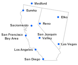
Figure 2 - Map of NWS Forecast Offices
in the CNRFC Area of Responsibility
The CNRFC provides hydrologic guidance for
time scales that vary from hours (flash flood guidance and support to
Local Flood Warning Systems), to days (traditional flood forecasts), to
weeks (snowmelt forecasts), to months (seasonal water supply) as shown
in Figure 3 below.
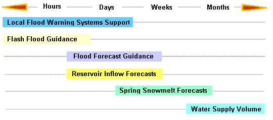
Figure 3 - Hydrologic guidance time scale
To develop this guidance the CNRFC employs a host of hydrologic
models and procedures that range from simple to complex and empirical
to process-simulation (Figure 4.).
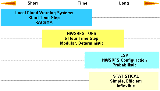
Figure 4. Time scale applications of
hydrologic models and procedures
The CNRFC is firmly committed to providing
the best possible river forecast guidance to its customers. Improvements
come in the form of expanded coverage and increased quality. Efforts
are continuously underway to improve the process used to forecast
flooding, spring snowmelt, and water supply volumes.
|