|
Weather Forecast Office (WFO) Hydrologic Products
IMPORTANT NOTE: NWS Offices can issue multiple versions of the same hydrologic product for different areas within
their area of hydrologic responsibility. Be sure to check "earlier versions" to view all products.
Stage Definitions
Hydrologic Statements
Flood Warnings - Small River and Stream Flood Warnings
Flood Statements - Urban and Small Stream Flood Advisories
Flood Watches - Flash Flood Watches
Flood Warnings - Flash Flood Warnings
Hydrologic Outlooks
Stage Definitions
NON-LEVEED STREAMS:

Monitor Stage - The Stage at which initial action must be taken by concerned interests (livestock warning,
removal of equipment from lowest overflow areas, or simply general surveillance of the situation). This level may produce overbank
flows sufficient to cause minor flooding of low-lying lands and local roads.
Flood Stage - The Stage at which overbank flows are of sufficient magnitude to cause considerable inundation
of land and roads and/or threat of significant hazard to life and property.
LEVEED STREAMS:
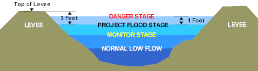
Monitor Stage
- The Stage at which patrol of flood control project levees by the responsible levee maintaining agency becomes mandatory, or the Stage
at which flow occurs into bypass areas from project overflow weirs.
Project Flood Stage - The Stage at which the flow in a flood control project is at maximum design capacity
(U.S. Corps of Engineers "Project Flood Plain"). At this level there is a minimum freeboard of 3 feet to the top of levees.
Danger Stage - The Stage at which the flow in a flood control project is greater than maximum design capacity
and where there is extreme danger with threat of significant hazard to life and property in the event of levee failure. This is generally
1 foot above project flood stage.
Hydrologic Statements
Issued when the main stem river is forecast to remain below flood stage.
*WFO Sacramento issues daily River Statements for the Sacramento River.
[back to top]
Flood Warnings/Small River and Stream Flood Warnings
Issued when flooding of main stem rivers is occurring or imminent. Main stem river flooding refers to flooding of gaged
and forecasted rivers. The FLW product can also be used to issue Small River and Stream Flood Warnings for smaller rivers/streams
which do not have forecast points.
[back to top]
Flood Statements / Urban and Small Stream Flood Advisories
Flood statements are follow-up statements to keep the public fully informed of the most current information. Statements
can be used to remove geographical areas covered by the original Flood Warning when flooding is no longer a threat or has ended in
that area. Statements are not used to extend the length of time or add an area to a warning. In those cases, a new Flood Warning
will be issued. Urban and Small Stream Flood Advisories are issued when minor widespread urban or flooding along small streams is occurring
or imminent. This type of flooding is generally an inconvenience and not life-threatening.
[back to top]
Flood/Flash Flood Watch
Used to inform of current or developing conditions that pose a threat of flooding, but the occurrence is neither certain
or imminent. Persons in the watch area are advised to check flood action plans, keep informed, and be ready to take action if a warning
is issued or flooding is observed.
[back to top]
Flash Flood Warning
Issued when flooding is reported; when precipitation capable of causing flooding is observed by radar and/or satellite;
when observed rainfall exceeds flash flood guidance or criteria known to cause flooding; or when a dam or levee failure has occurred
or is imminent. A flash flood is defined as a flood caused by heavy or excessive rainfall in a short period of time, and occurring generally
within 6 hours of the causative event.
[back to top]
Hydrologic Outlooks
Issued when forecast meteorological conditions indicate that a significantly heavy precipitation episode may occur that
would cause or aggravate flooding. It is generally issued for events expected to occur beyond 36 hours and out to three days from now.
[back to top]
|