|
Flood Forecasting
Traditional flood forecasts are provided for approximately
80 locations in the roughly two-state area. The diversity of hydrologic
regimes, the proximity to the Pacific Ocean, and the complications
of a highly developed water management environment make forecasting
extremely difficult. A great deal of coordination is required as
many federal, state, local, and private entities are involved in
storing, releasing, and diverting streamflow. Constant coordination
is performed with the U.S. Bureau of Reclamation (USBR), U.S. Army
Corps of Engineers (COE), and the California Department of Water
Resources (CADWR). In addition, numerous municipalities, irrigation
districts, and utility companies significantly affect river flows
and therefore must be included in the forecast process. A recent
office move resulted in the collocation of the CNRFC, WFO Sacramento,
the USBR, and the CADWR. This collocation has dramatically improved
the coordination between the NWS and USBR who manage the largest
reservoirs in the area.
Operational flood forecasting is highly dependent
upon reliable and timely data. The CNRFC relies on the data collected
by many other agencies and groups to support its flood forecasting
function. It is important to note that the flood forecasting function
relies entirely upon automated data as opposed to manual observations.
Automated data are transmitted from field sites using a variety
of techniques that include line-of-sight radio, microwave, satellite,
telephone, and meteor-burst. Agencies that collect and provide real
time hydrometeorological data include the CADWR, USBR, COE, U.S.
Geological Survey (USGS), U.S. Forest Service (USFS), U.S. Natural
Resources Conservation Service (NRCS), cities and counties with
local flood warning systems, numerous irrigation districts, and
several utility companies. In combination the network consists of
over 1200 rain gages, 600 air temperature sensors, 500 river gages,
and 120 gages that measure reservoir elevation. Many other parameters
such as wind speed, wind direction, relative humidity, and barometric
pressure are available. Data are collected in a local database and
screened for quality before being passed along to the river forecasting
model.
The winter flood season in the CNRFC area of responsibility
runs from late October through mid April. Additional routine staffing
and operational activities take place during this time of the year.
Quantitative precipitation forecasts (QPF) for the next three days
in six hour blocks are provided by the Hydrometeorological Prediction
Center during the winter. Forecasts of the snow level are also provided.
These weather forecasts are critical to the NWS’s ability to
provide adequate public warning time in the event of a winter flood.
Within the CNRFC, a staff of meteorologists operate the HAS (Hydrometeorological
Analysis and Support) function to integrate observed and forecast
weather into the river forecast models. These forecasters quality
control incoming temperature and precipitation data and monitor
developing meteorological conditions very closely to ensure that
the current QPF still reflects expected conditions (Figure 5).
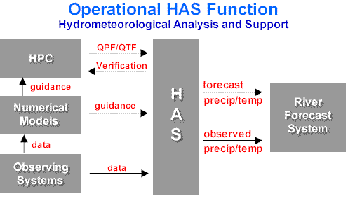
Figure 5 - Operational Hydrometerological Analysis and Support
The CNRFC uses the NWSRFS (National Weather Service
River Forecasting System) to simulate and project river flows and
stages in its area of responsibility. NWSRFS is a collection of
hydrologic models and infrastructure that handles the required parameters,
states, and data. A typical model configuration for forecasting
watershed response at a specific point along a river is shown in
Figure 6.
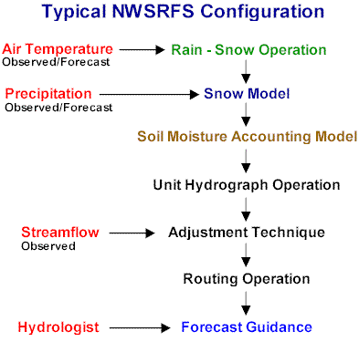
Figure 6 - Typical NWSRFS Configuration
It is important to note than most of the forecast
watersheds in the CNRFC require the use of a snow model. The snow
model mathematically accumulates solid precipitation, calculates
the heat content of the snowpack, and computes meltwater for delivery
to the soil model when the snowpack begins to melt. The temporal
delay caused by this natural process is important to both flood
management and water resources interests. If all precipitation in
the CNRFC fell as rain, flooding would be significantly worse and
more frequent and agricultural irrigation would be significantly
less reliable.
NWSRFS is operated locally in a quasi-interactive
fashion through a graphical user interface. The interface, called
the Interactive Forecast Program (IFP), allows the forecaster to
run, evaluate, and modulate the operation at each forecast point.
Model performance is evaluated over the last several days to several
weeks and the streamflow is projected for the next 3 to 5 days using
current model conditions as well as forecasts of temperature, precipitation,
and reservoir regulation. Figure 7 shows the hydrograph portion
of the IFP interface.
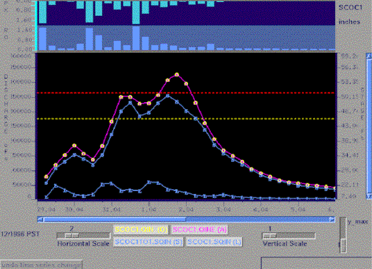
Figure 7 - NWSRFS Interactive Forecast Program (IFP) Display
In practice, the CNRFC breaks up its forecast workload
into eight geographic pieces. This allows forecasters to simultaneously
concentrate on specific problem areas. Routine forecasts for the
mainstem of the Sacramento River are provided daily. Other river
points are forecast when the current or expected stage exceeds established
criteria. The art of flood forecasting involves a delicate and skilled
balance of experience, analysis of current conditions, and analysis
of model guidance (Figure 8).
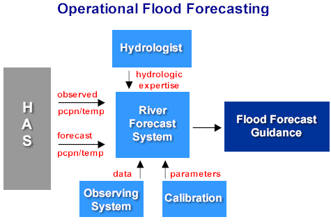
Figure
8 - Inputs to operational flood forecasting process
California State Law (Section 236) authorizes the
CADWR to either act independently or to cooperate with Federal agencies
or others in the collection of data for river forecasting, in making
forecasts of streamflow, in providing for flood warning, and in
providing communications for the collection and dissemination of
such information. As such, it is critical that the CADWR and the
NWS cooperate at an unprecedented level. Over time, the working
relationship with the CADWR has resulted in a joint operation whereby
CADWR and CNRFC personnel work together to develop flood forecast
guidance. Public dissemination is accomplished through normal NWS
channels as well as the State-Federal Flood Center. This close working
relationship benefits NWS customers by taking advantage of the resources
and expertise of both agencies. Duplication of effort is eliminated
and a single message reaches the emergency managers and the public.
In addition to flood forecasts, the CNRFC provides
3 day reservoir inflow forecasts to the appropriate water management
agencies. These forecasts allow reservoir operators to anticipate
regulation changes required by very wet or very dry weather. Reservoir
forecasts are produced in the flood forecast modeling process and
are updated at least once a day during the winter. During heavy
runoff events, the inflow forecasts are updated every six hours
or more often if required or conditions change. Reservoir operators
inform the CNRFC of regulation plans and changes so that planned
reservoir releases can be incorporated in downstream river forecasts.
|