AIRS Sulfur Dioxide (SO2) Data Product detects Mount Redoubt Eruption Cloud
The Atmospheric InfraRed Sensor on the Aqua satellite detected the sulfur dioxide cloud from the eruption of Mount Redoubt in Alaska on March 22. The WMS/OGC server provides data which show the movement of the eruption cloud in the atmosphere. Mount Redoubt erupted again on March 26.
On March 22, Alaska's Mount Redoubt, which had been seismically restless for several weeks, erupted explosively, sending several clouds of ash and volcanic gas into the atmosphere, and causing local floods due to melting ice and snow on the volcanic peak. Ash in the atmosphere caused the cancellation of many flights in and out of the Anchorage airport. Mount Redoubt erupted explosively again on the morning of March 26.
April 30: A new animated image of SO2 cloud transport has been added to this news item (see third image below).
The GES DISC is the archive of data from the Atmospheric InfraRed Sounder (AIRS). The AIRS L1 data set includes a BT_diff_SO2 parameter, which highlights the presence of atmospheric sulfur dioxide (SO2). The GES DISC produces regularly-updated maps of this parameter from the AIRS Near Real Time (NRT) data stream, and these maps are published to the GES DISC WMS/OGC server.
Below is an image and an animation of the SO2 data parameter, showing the Mount Redoubt eruption cloud. The image indicates that a portion of the cloud was entrained in strong high-level atmospheric winds, carrying that part of the cloud over central Canada. The data in the animation was modified to filter out any pixels not above the SO2 signature threshold.
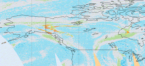
The animation is centered on Mount Redoubt.

The animation below shows the movement of the eruption clouds from the March 22, March 26, and March 27 eruptions of Mount Redoubt. Part of the SO2 cloud was transported over the Great Lakes and over the East Coast just north of Cape Cod. Depending on the actual height of these clouds, they can "etch" (the actual term is crazing) aircraft windows due to the acidity of water droplets which entrain some of the SO2 in the clouds. Such damage was reported following the eruption of El Chichón in 1983.