|
No Change in the Drought Situation |
|||||||||||||||||||||||||||||||||||||||||||||||||||||||||||||||||||||||||||||||||||||||||||||||||||||||||||||||||||||||||||||
| Summary: | |||||||||||||||||||||||||||||||||||||||||||||||||||||||||||||||||||||||||||||||||||||||||||||||||||||||||||||||||||||||||||||
|
From 7 AM April 28 through 7 AM May 5, 2009, between a half and two inches of precipitation fell across northeast Iowa and southeast Minnesota. Meanwhile much of western Wisconsin saw less than a half inch. Typically, the area usually receives around 8 tenths of an inch. The map below provides more detail on how much precipitation fell across the area during the aforementioned time period.
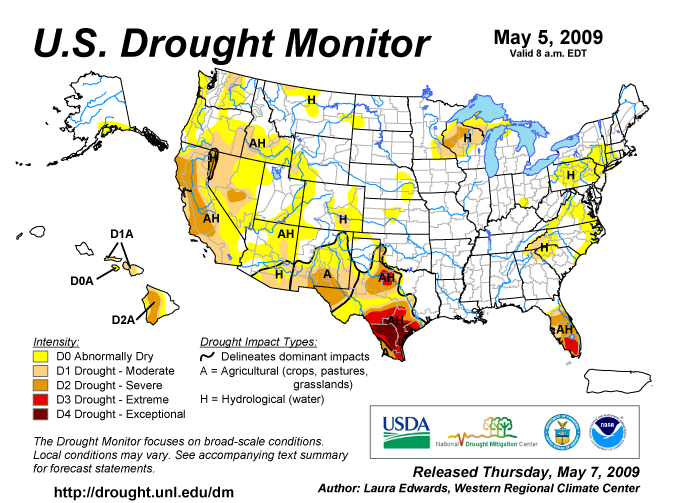
With the drought areas receiving below normal precipitation from Tuesday, April 28th through Tuesday, May 5th, there was no change in drought situation this week. In the short term (during 2009), the precipitation deficits are running between 1.50 and 3.00 inches below normal across southeast Minnesota, and west central, central, and north central Wisconsin. Through May 5th, Rochester International Airport has only received 4.71 inches of precipitation this year. This is 2.42 inches below the normal of 7.13 inches. La Crosse Municipal Airport has received 5.57 inches of precipitation this year. This is 2.54 inches below the normal of 8.11 inches. In the longer term, the precipitation deficits are running between 8 and 11 inches (since mid June 2008) across southeast Minnesota and 4 and 8 inches (since mid July 2008) in western Wisconsin. At this time, the moderate (D1) to severe (D2) drought is mainly affecting soil moisture and ground water levels in southeast Minnesota, and in west central, central, and north central Wisconsin. According to the Midwestern Regional Climate Center (MRCC), soil moisture is running 1 to 2 inches below normal across southeast Minnesota and west central Wisconsin. The depth of the ground water has declined 2.95 feet since mid July 2008 in Monroe County (Tomah, WI). Finally, the combination of long term dryness and below normal precipitation from Tuesday, April 28th through Tuesday, May 5th caused the river flows to rapidly decrease across much southeast Minnesota, northeast Iowa, and western Wisconsin. The lowest flows were reported along the Zumbro South Fork near Rochester, Minnesota (12th percentile). In the May 5th release of the U.S. Drought Monitor, severe (D2) drought was located from west central Wisconsin northeast into northeast Wisconsin. Abnormally dry (D0) and moderate drought (D1) conditions surrounded this severe drought area in eastern Minnesota, the northern two-thirds of Wisconsin, northeast and north central Iowa, Upper Michigan, and a small portion of northwest Lower Michigan.
Local Area Affected: Moderate (D1) to severe drought (D2) exist across Taylor County in north central Wisconsin; and Buffalo and Trempealeau counties in west central Wisconsin. Moderate (D1) drought conditions exist across Dodge, Olmsted, Wabasha, and Winona counties in southeast Minnesota; Clark County in north central Wisconsin; and Jackson County in central Wisconsin. Abnormally dry (D0) to moderate drought (D1) conditions exist across Mower, Fillmore, and Houston counties in southeast Minnesota; and La Crosse and Monroe counties in west central Wisconsin; and Juneau County in central Wisconsin. Abnormally dry (D0) conditions exist across all or parts of Howard, Mitchell, and Winneshiek counties in northeast Iowa; Vernon County in southwest Wisconsin; and Adams County in central Wisconsin.
State and Local Actions: Southeast Minnesota... Since mid June 2008, most locations in southeast Minnesota have received between 18 and 21 inches of precipitation. These totals are generally 8 to 11 inches below normal. Normally this area receives between 26 and 28 inches of precipitation from mid June 2008 through early May 2009. Due to these precipitation deficits, abnormally dry (D0) to moderate (D1) drought conditions are found across this area. The table below shows how much precipitation has fallen and precipitation deficits across southeast Minnesota from June 15, 2008 through May 5, 2009.
The image below is compliments of the Northeast Regional Climate Center (NERCC) and it compares the precipitation from July 1, 2008 to May 5, 2009 (blue line) at Rochester to normal (red line). The magenta line is the precipitation totals for 1976-77 which was the last time we were this dry (long term precipitation deficits) in late April. When the blue or magenta lines are below the red line, the precipitation total is below normal.
Western Wisconsin... Since mid July 2008, most locations in western Wisconsin have received between 14 and 18 inches of precipitation. These totals are between 4 and 8 inches below normal. Normally these areas receive between 23 and 25 inches of precipitation from mid July through early May. Due to these precipitation deficits, abnormally dry (D0) to severe drought (D2) conditions exist across western Wisconsin. The table below shows how much precipitation has fallen and precipitation deficits across parts of northeast Iowa and western Wisconsin from July 20, 2008 through May 5, 2009.
The image below is compliments of the Northeast Regional Climate Center (NERCC) and it compares the precipitation from July 1, 2008 to April 28, 2009 at La Crosse (blue line) to normal (red line). The tan line is the precipitation totals for 1976-77 which was the last time we were this dry (long term precipitation deficits) in late April. When the blue or tan lines are below the red line, the precipitation total is below normal.
|
The U.S. Drought Monitor is a weekly collaborative effort between a number of federal agencies including NOAA/NWS, U.S. Department of Agriculture and the National Drought Mitigation Center. Details and explanations of the Drought Monitor can found at the web site: http://www.drought.unl.edu/ The categories of drought are defined as follows: Moderate Drought (D1) - Some damage to crops, pastures; fire risk high; streams, reservoirs, or wells low, some water shortages developing or imminent, voluntary water use restrictions requested. Severe Drought (D2) - Crop or pasture losses likely; fire risk very high; water shortages common; water restrictions imposed. Extreme Drought (D3) - Major crop/pasture losses; extreme fire danger; widespread water shortages or restrictions. Exceptional Drought (D4) - Exceptional and widespread crop/pasture losses; exceptional fire risk; shortages of water in reservoirs, streams, and wells, creating water emergencies. |
||||||||||||||||||||||||||||||||||||||||||||||||||||||||||||||||||||||||||||||||||||||||||||||||||||||||||||||||||||||||||||
Soil Moisture Conditions: |
|||||||||||||||||||||||||||||||||||||||||||||||||||||||||||||||||||||||||||||||||||||||||||||||||||||||||||||||||||||||||||||
|
As of May 5th, the Midwestern Regional Climate Center (MRCC) indicated that the soil moisture in the top five feet ranged from 1 to 2 inches below normal across southeast Minnesota and west central Wisconsin. The image below is from the MRCC. Current Soil Moisture Deviation as of May 5, 2009 |
Additional information about soil moisture conditions can be found either at the Midwestern Regional Climate Center (MRCC) at: http://mrcc.isws.illinois.edu/cliwatch/drought/drought.jsp or at the NWS Climate Prediction Center (CPC) Web Site at: http://www.cpc.noaa.gov/products/soilmst/w.shtml
|
||||||||||||||||||||||||||||||||||||||||||||||||||||||||||||||||||||||||||||||||||||||||||||||||||||||||||||||||||||||||||||
Ground Water Impacts: |
|||||||||||||||||||||||||||||||||||||||||||||||||||||||||||||||||||||||||||||||||||||||||||||||||||||||||||||||||||||||||||||
|
On May 5th, the well water level just west of Tomah, Wisconsin (Monroe County) was 6.87 feet below ground level. This was 0.49 of a foot higher than April 28, 2009, and 2.65 feet lower than it was on August 1, 2008. Normally the water level should be 4.77 feet below ground level. This site is currently in the 10th percentile and the current May value is just 0.62 of a foot below the May record of 7.49 feet set in 1989. The image below is from the USGS and it shows how the ground level water has fluctuated from February 2007 through May 2009 just west of Tomah, WI. |
Additional information about ground levels can be found either at the USGS Ground-Water Climate Response Network at: http://groundwaterwatch.usgs.gov/ |
||||||||||||||||||||||||||||||||||||||||||||||||||||||||||||||||||||||||||||||||||||||||||||||||||||||||||||||||||||||||||||
River and Stream Flow Conditions: |
|||||||||||||||||||||||||||||||||||||||||||||||||||||||||||||||||||||||||||||||||||||||||||||||||||||||||||||||||||||||||||||
|
The combination of long term dryness and below normal precipitation from Tuesday, April 28th through Tuesday, May 5th caused the river flows to rapidly decrease across much southeast Minnesota, northeast Iowa, and western Wisconsin. The lowest flows were reported along the Zumbro South Fork near Rochester, Minnesota (12th percentile). Listed below are some current (May 5th) river and stream flows versus in cubic feet per second (cfs) compared to percentiles of historical daily stream flow for the day of the year. These are for selected rivers and streams in our service area with long periods (over 30 years) of record as measured by the United States Geological Survey (USGS).
|
Hourly and forecast river stages out to 90 days can be found at the National Weather Service's (NWS) Advanced Hydrologic Prediction Service (AHPS) web page: http://www.crh.noaa.gov/ahps2/ Additional Current stream and river stages may be viewed at the following USGS Web Site: |
||||||||||||||||||||||||||||||||||||||||||||||||||||||||||||||||||||||||||||||||||||||||||||||||||||||||||||||||||||||||||||
Fire Danger Hazards: |
|||||||||||||||||||||||||||||||||||||||||||||||||||||||||||||||||||||||||||||||||||||||||||||||||||||||||||||||||||||||||||||
|
As of the morning of May 5th, high fire danger was reported across central Wisconsin. Moderate fire danger was reported across north central and southwest Wisconsin. Finally, low fire danger was reported across southeast Minnesota. As a reminder, citizens should always check with local officials in their area before undertaking any outside burning. Citizens are liable for damages and suppression costs of any wildfire they may start. |
For updated DNR Fire Conditions consult the following Web Sites: In Minnesota: In Wisconsin: The Keetch-Byram Drought Index (KBDI) is a drought index that is specifically related to fire potential. The KDBI is broken into four categories which indicate the susceptibility of ground fuels to fire danger. Below are the four categories and a brief description of each.
KBDI and Dead Fuel Moisture data can be found on the Wildland Fire Assessment System (WFAS) web site at: |
||||||||||||||||||||||||||||||||||||||||||||||||||||||||||||||||||||||||||||||||||||||||||||||||||||||||||||||||||||||||||||
Agriculture Impacts: |
|||||||||||||||||||||||||||||||||||||||||||||||||||||||||||||||||||||||||||||||||||||||||||||||||||||||||||||||||||||||||||||
|
Minnesota: On May 6th, the Minnesota Field Office of USDA's National Agricultural Statistics Service (NASS) Minnesota stated that damp, cool conditions slowed fieldwork following last week's rapid pace. Rainfall was recorded at all reporting stations with amounts ranging from one quarter to over one inch of rainfall. Producers that were able to return to the fields late in the reporting period made progress in land prepared for corn and corn seeded with some producers making the transition to soybeans. Topsoil moisture was rated mostly adequate across the south and east; however, northern producers continue to deal with a soil moisture surplus. Statewide, 3.2 days were suitable for fieldwork. Land preparation and seeding of corn slowed following the rapid pace in the previous reporting period. Statewide, 73 percent of land prepared for corn was complete with 59 percent seeded. Land prepared for soybeans advanced to 19 percent complete with 7 percent seeded. Oats was 21 percent emerged with 77 percent of the crop rated in good to excellent condition. Spring wheat and barley were 16 and 19 percent planted respectively, well behind the five-year average. A large proportion of the spring wheat and barley growing areas remain wet with full-scale fieldwork yet to begin. Pastures were primarily in fair to good condition; however, the cool conditions slowed growth and greening. Topsoil moisture was rated 11 percent short to very short compared to 21 percent last week, while twenty-three percent was rated surplus compared to 25 percent a week ago. Wisconsin: On May 6th, the Wisconsin Field Office of USDA's National Agricultural Statistics Service (NASS) stated that precipitation during the week kept some farmers out of the fields over a dry and warm weekend. More consecutive days of heat are needed to dry out the ground, especially in low-lying areas. Across the reporting stations, precipitation totals ranged from 2.75 inches in Milwaukee to 0.52 inches in Green Bay. Average temperatures last week were normal to 4 degrees above normal. Average high temperatures ranged from 59 to 63 degrees, while average low temperatures ranged from 39 to 45 degrees. There were 3.6 days suitable for fieldwork. Corn planting continued where possible across the state, with 17 percent reported complete. Planting accelerated on the western side of the state, where growers benefited from good planting conditions. Many other growers are holding off and waiting for soil moisture conditions and temperatures to improve. Despite the previous week’s conditions, growers made good progress planting oats, with reported plantings at 74 percent complete. Almost all oats are in the ground in the southwest and south central parts of the state. Emergence progressed with some timely precipitation, and was reported as 31 percent complete statewide. Percent planted and emerged were each ahead of their 5-year averages. Spring tillage picked up towards the end of the week, with 50 percent reported complete. There is still a lot of tillage to be done in some areas, and growers are geared up and ready to go as soon as the conditions permit. The recent rains have helped winter wheat and alfalfa perk up, yet there have been many reported spots with winter kill. For the most part, reports indicate that winter wheat has suffered more damage than alfalfa. Winter wheat conditions were reported as 79 percent fair to good. Along with other crops, both could benefit from some warmer temperatures. The rains have helped pasture and hay growth in the central part of the state, with pasture conditions reported as 77 percent fair to good. Early canning peas were emerging and the planting of potatoes continued in the West Central district. Fruit trees were starting to bud throughout the state. The following were quotes from Farm Reporters and County Agriculture Agents: In Buffalo County, most oats have emerged. Manure spreading and planting corn are the activities going on. Cool temperatures are holding back hay and pastures. Fruit trees are starting to blossom. In Clark County, wheat damage is greater than expected and some fields will have to be replanted. Alfalfa has started to grow. We received a much-needed rain last week that has slowed fieldwork. Corn might be planted this weekend. In La Crosse County, the alfalfa is coming back and looking good. There is little evidence of winterkill. Tillage is ahead of schedule with corn planting starting to go strong. Ground works up better than most previous years. Fruit trees are starting to bud, have not seen any blossoms as yet. Soil temperature is between 55 and 60 degrees depending on the altitude. In the table below, there is a summary of the top soil moisture conditions across Minnesota and Wisconsin from the USDA's National Agricultural Statistics Service (NASS) summary.
|
Soil moisture supply measures how much moisture is present in cropland top soil during the week. Soil moisture is reported as a percentage. The categories very short, short, adequate and surplus must add up to 100%.
For additional information on agriculture impacts may be viewed at the United States Department of Agriculture (USDA) National Agricultural Statistics Service NASS Web Site: http://www.nass.usda.gov/Publications |
||||||||||||||||||||||||||||||||||||||||||||||||||||||||||||||||||||||||||||||||||||||||||||||||||||||||||||||||||||||||||||
Precipitation/Temperature Outlooks: |
|||||||||||||||||||||||||||||||||||||||||||||||||||||||||||||||||||||||||||||||||||||||||||||||||||||||||||||||||||||||||||||
|
From May 8th through May 12th, both temperatures and precipitation will be near normal. During this time frame, the daily average temperatures range from 54 to 59 degrees and the normal precipitation is around a half inch.
Beyond this time frame the 8 to 14 day forecast from the Climate Prediction Center (CPC) for the period May 13th through May 19th calls for above normal temperatures and precipitation. During this time frame, the daily average temperatures range from 56 to 61 degrees and the normal precipitation is around seven tenths of an inch. The seasonal outlook for June through August calls for below to near normal temperatures and equal chances of below, near, and above normal precipitation across the Upper Mississippi River Valley. |
For updated temperature and precipitation probabilities consult the following Climate Prediction Center (CPC) Web Sites: 8 to 14 Day Outlook: http://www.cpc.ncep.noaa.gov/ 30 Day Outlook: http://www.cpc.ncep.noaa.gov 90 Day Outlook: |
||||||||||||||||||||||||||||||||||||||||||||||||||||||||||||||||||||||||||||||||||||||||||||||||||||||||||||||||||||||||||||
Questions or Comments: |
|||||||||||||||||||||||||||||||||||||||||||||||||||||||||||||||||||||||||||||||||||||||||||||||||||||||||||||||||||||||||||||
|
If you have any questions or comments about this drought information please contact:
|
Other Contacts: |
||||||||||||||||||||||||||||||||||||||||||||||||||||||||||||||||||||||||||||||||||||||||||||||||||||||||||||||||||||||||||||
.png)
.png)
.png)
.png)

.png)

- National Weather Service
- La Crosse, WI Weather Forecast Office
- N2788 County Road FA
- LaCrosse, WI 54601
- 608-784-7294
- Page Author: ARX Webmaster
- Web Master's E-mail: w-arx.webmaster@noaa.gov
- Page last modified: May 8th 2009 11:55 AM