Electronic Filing

|
MB E-Filing Site
These FCC/MB forms MUST be electronically filed:
FCC Forms 301, 301-CA, 302-CA, 302-FM, 302-DTV, 302-TV, 303-S, 314,
315, 316, 318, 319, 323, 323-E, 337, 340, 346, 347, 349,
350, 381
EEO Forms 395-A and 395-B have been suspended by
Commission Order FCC 01-34.
CDBS Users Guide or call (202)-418-2662
CDBS System Status
Call Sign Reservations & Authorizations
for broadcast
station call signs
Antenna Structure Registration via ULS
|
|

Easy, one-stop access to all online U.S. Federal Government resources
www.USA.gov
|
|
|
M3 Map of Effective Ground
Conductivity in the USA
(A Wall Sized Map)
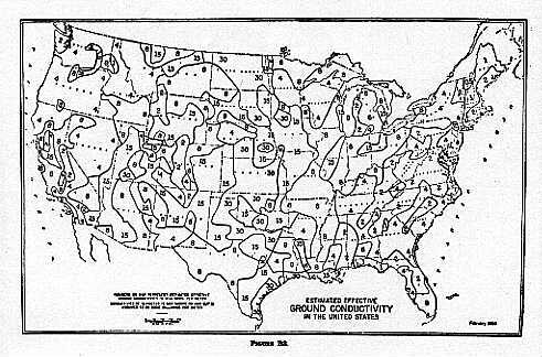
Figure R3 of 47 CFR 73.190 of the Commission's Rules contains
a map of the estimated effective ground conductivity in the United States.
This data is used to predict the propagation of AM signals across the United States. A
higher ground conductivity indicates better AM propagation characteristics. The maps below
show that the ground conductivity in the U.S. ranges between 0.5 and 30 millimhos per
meter. The conductivity of seawater is 5,000 millimhos per meter, resulting in the best
propagation of AM signals.
Small M3
Conductivity Map
Via the zipped file below, you may retrieve scanned map portions of a wall-sized
ground conductivity map, which may be printed, trimmed, and assembled into a 43 inch
by 69 inch map. There are 48 portions, arranged as shown in the table below, with
map 01w.jpg located in the upper northwest (Washington State). The map portions are
scanned for and best printed on 8 1/2 inch by 14 inch paper. ( Printing on smaller paper will
increase the number of map segments which much be joined. ) Together, the 48 map files
require 6.8 MB of memory. Separate conductivity maps for Alaska and Hawaii are also included
in the zipped file.
The M3 conductivity data is also available as text files through the Internet.
Data for the continental USA is located in the file m3.seq,
which also contains updated conductivity data for the Chesapeake Bay and Puget
Sound that is not shown on the wall map. Data for Hawaii is contained in the
file m3hw.seq.
Data for the rest of Region 2 (the Western Hemisphere) is contained in the
file r2.seq.
This page is located at http://www.fcc.gov/mb/audio/m3/index.html.
|
|
