
 Feeds & Data
Magnitude 6.9 - NORTHERN MID-ATLANTIC RIDGE
2008 February 08 09:38:14 UTC
Earthquake Details
| Magnitude | 6.9 |
|---|---|
| Date-Time |
|
| Location | 10.733°N, 41.884°W |
| Depth | 10 km (6.2 miles) set by location program |
| Region | NORTHERN MID-ATLANTIC RIDGE |
| Distances |
|
| Location Uncertainty | horizontal +/- 5.3 km (3.3 miles); depth fixed by location program |
| Parameters | Nph=203, Dmin=194.3 km, Rmss=0.85 sec, Gp= 40°, M-type=regional moment magnitude (Mw), Version=A |
| Source |
|
| Event ID | us2008nean |
- This is a computer-generated message -- this event has not yet been reviewed by a seismologist.
- Did you feel it? Report shaking and damage at your location. You can also view a map displaying accumulated data from your report and others.
Earthquake Maps

Earthquake Location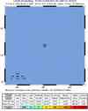
ShakeMap
PAGER
Population Exposure
Google Map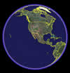
Google Earth KML
(Requires Google Earth)- Did you feel it? Report shaking and damage at your location. You can also view a map displaying accumulated data from your report and others.
- Preliminary Earthquake Report
- U.S. Geological Survey, National Earthquake Information Center:
World Data Center for Seismology, Denver
