
 Feeds & Data
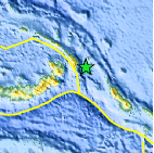
Magnitude 7.7 - NEW IRELAND REGION, PAPUA NEW GUINEA - uscuah
2005 September 9 07:26:43 UTC
A major earthquake occurred at 07:26:43 (UTC) on Friday, September 9, 2005. The magnitude 7.7 event has been located in the NEW IRELAND REGION, PAPUA NEW GUINEA. (This event has been reviewed by a seismologist.)

Earthquake Details
| Magnitude | 7.7 |
|---|---|
| Date-Time |
= Coordinated Universal Time = local time at epicenter |
| Location | 4.539°S, 153.445°E |
| Depth | 91.3 km (56.7 miles) set by location program |
| Region | NEW IRELAND REGION, PAPUA NEW GUINEA |
| Distances | 45 km (30 miles) E of Taron, New Ireland, PNG 145 km (90 miles) ESE of Rabaul, New Britain, PNG 885 km (550 miles) NE of PORT MORESBY, Papua New Guinea 2535 km (1580 miles) N of BRISBANE, Queensland, Australia |
| Location Uncertainty | horizontal +/- 4.6 km (2.9 miles); depth fixed by location program |
| Parameters | Nst=276, Nph=276, Dmin=898.4 km, Rmss=0.99 sec, Gp= 40°, M-type=teleseismic moment magnitude (Mw), Version=S |
| Source | USGS NEIC (WDCS-D) |
| Event ID | uscuah |


- Preliminary Earthquake Report
- U.S. Geological Survey, National Earthquake Information Center
World Data Center for Seismology, Denver
