
 Feeds & Data
Magnitude 6.5 - MINDORO, PHILIPPINES
2004 October 8 14:36:06 UTC


Earthquake Details
| Magnitude | 6.5 (Strong) |
|---|---|
| Date-Time |
= Coordinated Universal Time = local time at epicenter |
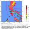
| Location | 13.954°N, 120.533°E |
| Depth | 105 km (65.2 miles) set by location program |
| Region | MINDORO, PHILIPPINES |
| Distances | 55 km (35 miles) WNW of Batangas, Luzon, Philippines 85 km (55 miles) SSW of MANILA, Philippines 90 km (55 miles) NW of Calapan, Mindoro, Philippines 105 km (65 miles) SSE of Olongapo, Luzon, Philippines |
| Location Uncertainty | horizontal +/- 4.6 km (2.9 miles); depth fixed by location program |
| Parameters | Nst=230, Nph=230, Dmin=>999 km, Rmss=0.91 sec, Gp= 22°, M-type=teleseismic moment magnitude (Mw), Version=T |
| Source | USGS NEIC (WDCS-D) |
| Event ID | uspibl |
- This event has been reviewed by a seismologist.
Did you feel it?
Report shaking and damage at your location. You can also view a map displaying accumulated data from your report and others.


- Preliminary Earthquake Report
- U.S. Geological Survey, National Earthquake Information Center
World Data Center for Seismology, Denver
