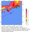
Magnitude 7.2 - NEAR S. COAST OF WESTERN HONSHU, JAPAN
2004 September 5 10:07:07 UTC
Earthquake Summary
USGS News Release
Felt Reports
At least four people injured in the Kyoto area. Felt in much of southwestern Japan and as far northeast as Tokyo. A local tsunami was generated with wave heights (peak-to-trough) of about 51 cm in Wakayama Prefecture. Recorded (5L JMA) in Mie, Nara and Wakayama; (4 JMA) in Aichi, Gifu, Hyogo, Kyoto, Osaka and Shiga; (3 JMA) in Chiba, Fukui, Hiroshima, Kanagawa, Nagano, Okayama, Shimane, Shizuoka, Tokyo, Tottori and Yamanashi; (2 JMA) in Gumma, Ishikawa, Saitama, Tochigi, Toyama and Yamaguchi (1 JMA) in Ibaraki, Miyagi and Niigata Prefectures. Recorded (3 JMA) in Kagawa, Kochi and Tokushima; (2 JMA) in Ehime Prefectures, Shikoku. Recorded (1 JMA) in Kagoshima, Kumamoto, Miyazaki and Oita Prefectures, Kyushu. Also recorded (3 JMA) on Kozu-shima, Nii-jima and O-shima; (2 JMA) on Hachijo-jima, Mikura-jima and Miyake-jima; (1 JMA) on Dogo and the Dozen islands.
Tectonic Summary
Tectonic Summary
Earthquake Information for Japan
Earthquake Details
| Magnitude |
7.2 (Major) |
| Date-Time |
Sunday, September 5, 2004 at 10:07:07 (UTC)
= Coordinated Universal Time
Sunday, September 5, 2004 at 7:07:07 PM
= local time at epicenter
Time of Earthquake in other Time Zones
|
| Location |
33.062°N, 136.608°E |
| Depth |
14 km (8.7 miles) set by location program |
| Region |
NEAR S. COAST OF WESTERN HONSHU, JAPAN |
| Distances |
180 km (110 miles) S of Tsu, Honshu, Japan
185 km (115 miles) SE of Wakayama, Honshu, Japan
205 km (130 miles) SSE of Osaka, Honshu, Japan
410 km (255 miles) SW of TOKYO, Japan
|
| Location Uncertainty |
horizontal +/- 3.5 km (2.2 miles); depth fixed by location program |
| Parameters |
Nst=398, Nph=398, Dmin=412.5 km, Rmss=0.85 sec, Gp= 36°,
M-type=teleseismic moment magnitude (Mw), Version=T
|
| Source |
USGS NEIC (WDCS-D)
|
| Event ID |
usnaah |
- This event has been reviewed by a seismologist.
- Report shaking and damage at your location. You can also view a map displaying accumulated data from your report and others.
Earthquake Maps

Earthquake Location
- Report shaking and damage at your location. You can also view a map displaying accumulated data from your report and others.
Scientific & Technical Information
- Preliminary Earthquake Report
- U.S. Geological Survey, National Earthquake Information Center
World Data Center for Seismology, Denver

 Feeds & Data