 |
 |
 |
 |
|
How To Track A Hurricane
The National Hurricane Center, which is part of the National Weather Service and the National Oceanic and Atmospheric Administration, tracks tropical storms and hurricanes.
Hurricane watches and warnings are issued when the storms get close to the U.S. You can track the progress of storms by listening to the coordinates given by your television meteorologists. Or you can regularly check on http://www.nhc.noaa.gov/ for the latest longitude and latitude locations issued by the National Hurricane Center.
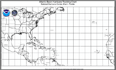
You can print out this tracking map or ![]() download the Tracking
Map PDF (906 KB) to make your own tracking maps. (You
will need the Adobe Acrobat Reader) Where do you think the storms
will go?
download the Tracking
Map PDF (906 KB) to make your own tracking maps. (You
will need the Adobe Acrobat Reader) Where do you think the storms
will go?