


| NOAA > NWS > CPHC | ||
| Press refresh or reload for the latest information. This page was last loaded at 359 pm HST Aug 24, 2009 (159Z Aug 25, 2009) | ||
Central Pacific (140W to 180)  | ||
| ||
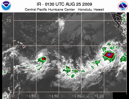
400 PM HST MON AUG 24 2009 1. The Central Pacific Hurricane Center in Honolulu, Hawaii is issuing advisories on tropical storm Hilda, located about 625 miles east southeast of Hilo, Hawaii. Hilda is moving westward around 10 mph. Public advisories on Hilda are being issued under WMO header WTPA25 PHFO and under AWIPS header HFOTCPCP5. | ||
(click for larger image) This is an experimental product (Product Description Document). Comments about this new graphic? Please send us an email or complete a short survey. | ||
| Sea Surface Temperatures in the East and Central Pacific | ||
| CPHC Widgets - Tracks and Tips | ||
| Satellite Interpretation Message Area Forecast Discussion | ||
| Western Pacific (West of 180) | ||
| Monitored by the: Joint Typhoon Warning Center Japan Meteorological Agency | ||
| Eastern Pacific (East of 140W) | ||
| ||
|
Eastern Pacific Graphical Tropical Weather Outlook 500 PM PDT MON AUG 24 2009 FOR THE EASTERN NORTH PACIFIC...EAST OF 140 DEGREES WEST LONGITUDE.. THE NATIONAL HURRICANE CENTER HAS INITIATED ADVISORIES ON TROPICAL DEPRESSION TWELVE-E...LOCATED ABOUT 660 MILES SOUTHWEST OF THE SOUTHERN TIP OF BAJA CALIFORNIA. PUBLIC ADVISORIES ON TROPICAL DEPRESSION TWELVE-E ARE ISSUED UNDER WMO HEADER WTPZ32 KNHC AND UNDER AWIPS HEADER MIATCPEP2. FORECAST/ ADVISORIES ON TROPICAL DEPRESSION TWELVE-E ARE ISSUED UNDER WMO HEADER WTPZ22 KNHC AND UNDER AWIPS HEADER MIATCMEP2. ELSEWHERE...TROPICAL CYCLONE FORMATION IS NOT EXPECTED DURING THE NEXT 48 HOURS.
| ||
| Monitored by the National Hurricane Center (NHC) | ||
 Loop satellite | ||
| ||
Saffir-Simpson Scale
| ||