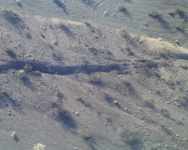
Title: Aerial Photo of the Surface Rupture
Description: Downward view onto gullies, gravel bar, and other laterally offset features. Here slip appears to be about 2 meters.
Location: CA, USA
Date Taken: 10/1/1999
Photographer: Paul "Kip" Otis-Diehl,
USMC, 29 Palms
Usage: This image is public domain/of free use. Please refer to the USGS Copyright section for more details.
Source:
File Size (original): JPEG Image - 274.19 KB
Suggest an update to the information/tags?
Tags: HectorMine aerial earthquake


")


