USGS - science for a changing world

Natural Hazards

Maps, Imagery, and Publications Hazards Newsroom Education Jobs Partnerships Library About USGS Podcasts/RSS

Back to Natural Hazards Gateway Home

Map illustration: caption below
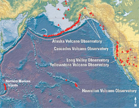
The U.S. Geological Survey (USGS) is responsible for monitoring our Nation's 170 active volcanoes (red triangles) for signs of unrest and for issuing timely warnings of hazardous activity to government officials and the public. This responsibility is carried out by scientists at the five volcano observatories operated by the USGS Volcano Hazards Program and also by State and university cooperators.
(Low-res)

Natural Hazards - Volcanoes

When the violent energy of a volcano is unleashed, the results can be catastrophic. The risks to life, property, and infrastructure are escalating as more and more people live, work, play, and travel in volcanic regions.

To help keep communities safe, it is essential to monitor hazardous volcanoes so that the public knows when unrest begins and what hazards can be expected.

The USGS has greatly advanced its ability to evaluate volcanic risks and hazards through research and monitoring programs. USGS realtime volcano-monitoring tools collect and transfer large amounts of data from remote volcanoes for analysis and interpretation.

USGS's analyses and interpretations help the public, policymakers, and emergency managers make informed decisions on how to prepare for and react to volcano hazards and reduce losses from future volcanic eruptions and debris flows.

Recent Volcano Observatory Activity Reports

  • Mauna Loa Status Report issued Aug 24, 2009 10:58 HST Volcano Alert Level ADVISORY - Aviation Color Code YELLOW
    Mauna Loa is not erupting. Slow extension, as measured by GPS receivers on opposite sides of the volcano, continued. Line lengths continue to slowly increase, due mostly to slippage on faults beneath Mauna Loa's east flank and not to an increase in magma supply to the volcano. Tiltmeters have recorded no significant changes other than abrupt offsets that are related to instrumental issues, severe weather, or significant earthquakes. Sensors within a fissure in Moku`aweoweo crater floor continued to record background gas concentrations and fumarole temperatures. Since the beginning ...

  • Redoubt Status Report issued Aug 24, 2009 11:52 ADT Volcano Alert Level ADVISORY - Aviation Color Code YELLOW
    No significant activity has been observed at Redoubt over the past 24 hours. Seismic activity remains low. Web camera images show continued emission of water vapor and gases from the lava dome, and fresh snow on the edifice. The dome remains potentially unstable, and could collapse with little or no warning, likely resulting in significant ash production, hot block and ash flows, and flooding in the Drift River valley. Although the operations center is not staffed 24/7, AVO continues to monitor the volcano on a 24/7 basis using an alarm system that alerts on-call staff of potential ...

  • Shishaldin Status Report issued Aug 24, 2009 11:52 ADT Volcano Alert Level ADVISORY - Aviation Color Code YELLOW
    Seismic activity at Shishaldin remains low, and deformation and gas emission data do not show anything abnormal at the volcano. Satellite images have been obscured by clouds over the past 24 hours. Web camera images, when clear, show nothing abnormal. There is currently no indication that an eruption will occur. AVO continues to closely monitor activity at Shishaldin.

  • Kilauea Daily Update issued Aug 24, 2009 07:23 HST Volcano Alert Level WATCH - Aviation Color Code ORANGE
    Activity Summary for past 24 hours: Incandescence in the Halema`uma`u Overlook vent was recorded overnight by Webcam. Sulfur dioxide emission rates from the Halema`uma`u and east rift zone vents remain elevated. Lava from the TEB vent, on the east rift zone, flows through tubes to the Waikupanaha ocean entry west of Kalapana. Past 24 hours at Kilauea summit: The Halema`uma`u Overlook vent continues to glow at night, with an incandescent hole on the floor of the vent visible on the Overlook Webcam after dark. The plume is blowing to the southwest this morning. The most recent ...


    Accessibility FOIA Privacy Policies and Notices

    Take Pride in America logo USA.gov logo U.S. Department of the Interior | U.S. Geological Survey
    URL: http://www.usgs.gov/hazards/volcanoes/default.asp
    Page Contact Information: Ask USGS
    Page Last Modified: Tuesday, July 08, 2008