)
NDMC's Drought
Impact Reporter
Impact Reporter
6-week
animation
animation
12-week
animation
animation
short-term drought
indicator blends
indicator blends
long-term drought
indicator blends
indicator blends


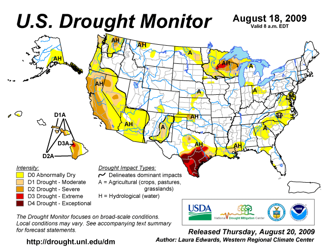
Visit the NDMC Photo Gallery to see photos of drought conditions in California, Georgia, South Carolina, and other states. If you have photos showing drought conditions, please consider submitting them to the Photo Gallery. The data cutoff for Drought Monitor maps is Tuesday at 7 a.m. Eastern Standard Time. The maps, which are based on analysis of the data, are released each Thursday at 8:30 a.m. Eastern Time. NOTE: To view regional drought conditions, click on map below. State maps can be accessed from regional maps. |
To compare current drought conditions with last week’s map, click here. |
| To view tabular statistics of this week's Drought Monitor, click here. | To view tabular statistics for the Drought Monitor archive, click here. |
| To view Drought Monitor Change Maps, click here. |
NDMC's Drought Impact Reporter |
6-week animation |
12-week animation |
short-term drought indicator blends |
long-term drought indicator blends |
|
|
|
|
|
| For a .pdf version of the Drought Monitor, click here. |
| For more information on the Drought Impact Reporter click here. |
| For annual animations of the Drought Monitor click here. |
| For more information on the above experimental drought blends, see http://www.cpc.ncep.noaa.gov/products/predictions/tools/edb/droughtblend-access-page.html#exp. |
| The drought indicators that are synthesized into the Drought Monitor map are on this website, under Forecasts and Current Conditions. |
| This summary map is based on a multi-index drought classification scheme. |
| For local details and impacts, please contact your State Climatologist or Regional Climate Center. |
| Free Online Sources of Historical Weather Data |
| Contact People |
| North American Drought Monitor |
| The discussion in the Looking Ahead section is simply a description of what the official national guidance from the National Weather Service (NWS) National Centers for Environmental Prediction is depicting for current areas of dryness and drought. The NWS forecast products utilized include the HPC 5-day QPF and 5-day Mean Temperature progs, the 6-10 Day Outlooks of Temperature and Precipitation Probability, and the 8-14 Day Outlooks of Temperature and Precipitation Probability, valid as of late Wednesday afternoon of the USDM release week. The NWS forecast web page used for this section is: http://www.cpc.ncep.noaa.gov/products/forecasts/. The Northeast and Mid-Atlantic: Most of this region was left unchanged this week. Some areas are drying out in northern Virginia where abnormally dry conditions (D0) was introduced this week. In southeastern Virginia and northeastern North Carolina, the D0 designation was removed due to recent heavy precipitation events during the last seven days. Some areas received over five inches of rain, and are now four to eight inches above normal for the last 30 days. Southeast: While a wet week benefited the northeast part of North Carolina, the Central Piedmont continued to be passed over with this week’s storm systems. As a result of increasing precipitation deficits in this region, streamflow on the decrease and reservoir levels slowly dropping, moderate drought was introduced in the Upper Cape River basin. For the same reasons, abnormally dry conditions were expanded in south central North Carolina, roughly south of a line from Charlotte to Raleigh. In Florida, some short-term improvements in drought conditions are reflected in reduction of D0 in the southwestern part of the state. In north Florida, precipitation deficits are growing for the summer season and abnormally dry designation was introduced from approximately Tallahassee to I-75. No other changes were made in the southeast this week, with Tropical Depression Claudette moving through Alabama, staving off drought expansion. Areas of west central Wisconsin and central Minnesota were beneficiaries of more than 6 inches locally in previous D1, or moderate drought, regions. Improvements were made in both locations around Eau Claire county, WI, and west of Wright county, MN. In south central Minnesota, the lack of rain is having a bigger impact and D1 was expanded over Mankato and Blue Earth county. Abnormally dry conditions persist in areas of northern Iowa with precipitation deficits for the last several months, and impacts on crop and soil moisture are now being reported. A new area of D0 was introduced in north central Iowa. The Plains: In Nebraska, a swath of two to four inches of rain fell in the current Drought Monitor period. This will greatly benefit soybean crops, and help in the corn fields. Reductions of D0 and D1 were made as a result in eastern Nebraska from Kearney to Lincoln. Improvements due to beneficial rainfall were made in some Oklahoma drought areas. All drought designations were removed from eastern Oklahoma. Several counties on the east and south side of the core drought in the state also improved one category due to weekly precipitation observations of over two inches in many areas. Several small changes were made in Texas this week to reflect the slightly changing conditions around the exceptional drought in this state. Rain helped the panhandle region and an area southeast of San Antonio, and some improvements are depicted in these regions. Amarillo has now received record August monthly precipitation of 9.08 inches, with two weeks yet to go. Elsewhere, drought continues to expand in severity and extent. Several counties in central and north central Texas were degraded by one category. Despite decent rain in Shackelford county, surrounding areas continue to miss out, and some expansion was made here. The West: A thorough assessment was done for Montana, resulting in removal of abnormally dry conditions throughout most of the state. Dry conditions remain around Glacier National Park and the Blackfeet reservation, and a small area southeast of there. Several days of rain and showers across the state have helped to alleviate dry conditions. The North American monsoon has brought less than expected rain to the southwestern states this summer. Moderate drought was introduced in Arizona to show degrading drought conditions in this state. In northwestern California, impacts on the Klamath River water supply and nearby areas led to an expansion of D0 in Del Norte county. North central Washington continues to experience degrading conditions with low precipitation and warm temperatures, and severe drought (D2) was expanded to the Canadian border. Hawaii, Alaska and Puerto Rico: In Hawaii, Tropical Storm Felicia brought a number of improvements to the state’s drought on three of the islands. Kauai is left with abnormal dry conditions in the southwest, Oahu is left drought-free, and east Maui was improved by one category. Heavy rainfall east of Anchorage this week, with areas totaling over five inches, made way for clearing of abnormal dry condtions. Elsewhere in the state was left unchanged. Looking Ahead: In the near-term, storminess associated with a cold front will continue through the central US for the next couple of days before moving over the Great Lakes. Hurricane Bill appears to be moving back out to sea, and poses no threat to making landfall. For the next five days, precipitation will favor the eastern states, with climatologically dry conditions continuing in the West. The monsoon appears to remain relatively quiet for this time of year in the Southwest. In the six to ten day forecast, the western continental US is projected to have above normal temperatures, and the east with below normal temperatures. During this period, precipitation is expected to be below normal in the northern states from Washington to Wisconsin, and above normal rainfall along the Eastern Seaboard. These are consistent with a ridge pattern in the west and a trough in the east. According to the Climate Prediction Center, model agreement is reasonable for this period. Alaska is projected to have below normal temperatures across the entire state, and below normal precipitation everywhere except the southeast where it may be wetter than normal. |
| Dryness Categories |
| D0 ... Abnormally Dry ... used for areas showing dryness but not yet in drought, or for areas recovering from drought.
Updated August 19, 2009 |
|
|