
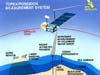
JPL's Seasat mission established that a satellite could use radar pulses to measure its altitude from Earth's surface. Taken over the world's oceans, these measurements could provide a high-fidelity view of the changing heights of the seas. That became the focus for the joint U.S.-French Topex/Poseidon mission.
Under the joint plan between NASA and France's National Center for Space Studies (known as CNES for its acronym in French), the United States provided the satellite, altimeter, a microwave radiometer, an experimental satellite tracking receiver and various spacecraft subsystems. France supplied launch on an Ariane 42P rocket from French Guiana in South America, as well as two instruments on the satellite -- a solid-state altimeter and a Doppler tracking receiver. Topex is short for "Ocean Topography Experiment," the name of the original U.S. mission proposal, while Poseidon was the name of the original French mission proposal.
From its orbit 1,336 kilometers (830 miles) above Earth's surface, Topex/Poseidon measured sea level every 10 days using the altimeter instruments developed by NASA and CNES. Using this information, scientists can relate changes in ocean currents to atmospheric and climate patterns. Measurements from the satellite's radiometer provided estimates of the total water-vapor content in Earth's atmosphere, which is used to correct errors in the altimeter measurements. These combined measurements allowed scientists to chart the height of the seas across ocean basins with an accuracy of less than 10 centimeters (4 inches). Although originally planned for a three- to five-year mission, Topex/Poseidon operated for more than 13 years after its launch.
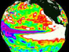
Among other science findings, Topex/Poseidon provided a unique view of the El Niño phenomenon of the late 1990s, an unusual water warming in the eastern Pacific Ocean. That El Niño was followed by a rebound effect of cold water conditions that came to be known as La Niña.
The satellite was built for JPL by Fairchild Space Co.
In October 2005, after 62,000 orbits of Earth, the mission ended when the spacecraft lost its ability to maneuver, bringing to a close history's longest Earth-orbiting radar mission.
Mass: 2,500 kilograms (about 5,510 pounds) Dimensions: 2.8 by 5.5 meters (9.2 by 18 feet), plus solar panel 3.3 by 8.7 meters (10.8 by 28.5 feet) Science instruments: Altimeters, microwave radiometer, Global Positioning System receiver, Doppler tracking receiver, laser retroreflector

Launch: August 10, 1992
Data From Newest Ocean Satellite Ready for Their 'Close-up' (8/6/09)
New Oceanography Mission Data Now Available (12/16/08)
Oscillation Rules as the Pacific Cools (12/9/08)
Ocean Surface Topography Mission/Jason 2 Begins Mapping Oceans (7/30/08)
Ocean Surface a Boon for Extreme Event Forecasts, Warnings (7/16/08)
NASA Mission to be Crystal Ball into Oceans' Future, Mirror to the Past (7/8/08)
![]() + Topex/Poseidon home page
+ Topex/Poseidon home page
+ Oceanography from Space fact sheet
+ For more information
+ Spotlight: The End of an Era