
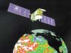
Jason 1 is an oceanography mission to monitor global ocean circulation, study the ties between the oceans and atmosphere, improve global climate forecasts and predictions, and monitor events such as El Niño conditions and ocean eddies.
It is a follow-on to the Topex/Poseidon mission, which measured ocean topography from 1992 through 2005. Like its predecessor, Jason 1 is a joint mission of the United States and France. These two satellites provide a unique global view of the oceans that is impossible to acquire using traditional ship-based sampling.
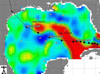
Like Topex/Poseidon, Jason 1 measures the large and small hills and valleys of the ocean's surface. These measurements of ocean topography allow scientists to calculate the speed and direction of ocean currents and monitor global ocean circulation.
The global ocean is Earth's primary storehouse of solar energy. Jason 1's measurements of sea-surface height reveal where this heat is stored, how it moves around Earth by ocean currents, and how these processes affect weather and climate.
Jason 1 is designed to directly measure climate change through very precise millimeter-per-year measurements of global sea-level changes.
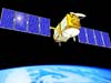
The Jason 1 satellite, its altimeter instrument and a position-tracking antenna were built in France. The spacecraft also carries a radiometer instrument to measure water vapor, a Global Positioning System receiver and a laser retroreflector array built in the United States. Jason 1 was launched in December 2001 from California's Vandenberg Air Force Base.
Weighing 500 kilograms (about 1,100 pounds), Jason 1 is one-fifth the size of Topex/Poseidon. Jason 1 flew in tandem with Topex/Poseidon until the latter spacecraft ceased operations, doubling the science data return. The mission is planned to last for five years.
Purpose: Measure sea surface heights
Launch: December 7, 2001
Data From Newest Ocean Satellite Ready for Their 'Close-up' (8/6/09)
NASA Study Finds 'Pre-Existing Condition' Fueled Killer Cyclone (2/26/09)
New Oceanography Mission Data Now Available (12/16/08)
Oscillation Rules as the Pacific Cools (12/9/08)
Sea Level Monitoring Enters New Era (10/31/08)
Will Gustav Dodge the Gulf's Warmest Waters? (8/28/08)