USGS - science for a changing world

Natural Hazards

Maps, Imagery, and Publications Hazards Newsroom Education Jobs Partnerships Library About USGS Podcasts/RSS

Back to Natural Hazards Gateway Home

Map illustration: caption below
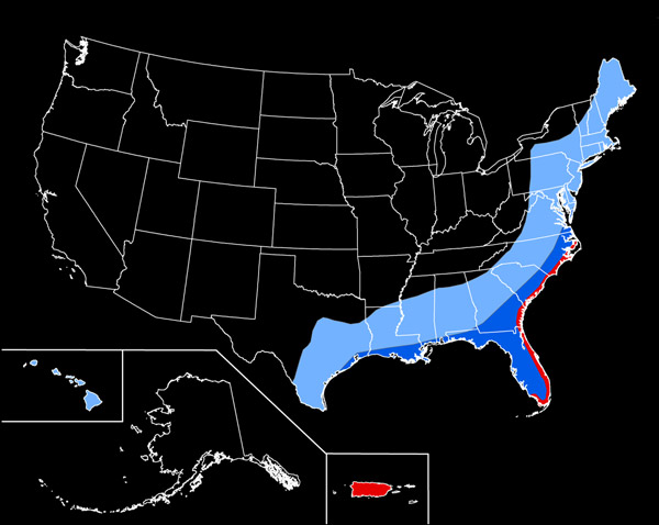
The number of hurricanes expected to occur during a 100-year period based on historical data—light blue area, 20 to 40; dark blue area, 40 to 60; red area, more than 60. Map not to scale. Source: the National Atlas and the USGS
(Hi-res | Low-res)

Natural Hazards - Hurricanes

Hurricanes bring destructive winds, storm surge, torrential rain, flooding, and tornadoes. A single storm can wreak havoc on coastal and inland communities and on natural areas over thousands of square miles.

In 2005, Hurricanes Katrina, Rita, and Wilma demonstrated the devastation that hurricanes can inflict and the importance of hurricane hazards research and preparedness.

More than half of the U.S. population lives within 50 miles of a coast, and this number is increasing. Many of these areas, especially the Atlantic and Gulf coasts, will be in the direct path of future hurricanes. Hawaii is also vulnerable to hurricanes.


USGS Hurricane Related News (USGS Newsroom)

   View more news related to Hurricanes


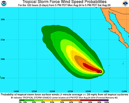
NOAA: National Hurricane Center (Atlantic)

  • Atlantic Tropical Weather Outlook

    000
    ABNT20 KNHC 250534
    TWOAT
    TROPICAL WEATHER OUTLOOK
    NWS TPC/NATIONAL HURRICANE CENTER MIAMI FL
    200 AM EDT TUE AUG 25 2009

    FOR THE NORTH ATLANTIC...CARIBBEAN SEA AND THE GULF OF MEXICO...

    A LARGE AREA OF CLOUDINESS AND THUNDERSTORMS CENTERED ABOUT 275
    MILES EAST-NORTHEAST OF THE NORTHERN LEEWARD ISLANDS IS ASSOCIATED
    WITH A TROPICAL WAVE INTERACTING WITH AN UPPER-LEVEL LOW. THERE ARE
    NO SIGNS OF A SURFACE CIRCULATION AT THIS TIME...BUT UPPER-LEVEL
    WINDS COULD BECOME A LITTLE MORE FAVORABLE FOR SLOW DEVELOPMENT
    DURING THE NEXT DAY OR TWO AS THE ACTIVITY MOVES TOWARD THE
    WEST-NORTHWEST AT 20 TO 25 MPH. THERE IS A MEDIUM CHANCE...30 TO 50
    PERCENT...OF THIS SYSTEM BECOMING A TROPICAL CYCLONE DURING THE
    NEXT 48 HOURS.

    AN AREA OF DISTURBED WEATHER ASSOCIATED WITH A BROAD AREA OF LOW
    PRESSURE LOCATED OVER THE EXTREME SOUTHWESTERN CARIBBEAN SEA IS
    MOVING WESTWARD OVER SOUTHERN NICARAGUA AND NORTHERN COSTA RICA.
    DEVELOPMENT IS NOT ANTICIPATED AND...IF ANY...WILL BE SLOW TO OCCUR
    WHEN THE SYSTEM REACHES THE EASTERN PACIFIC IN A DAY OR SO. THERE
    IS A LOW CHANCE...LESS THAN 30 PERCENT...OF THIS SYSTEM BECOMING A
    TROPICAL CYCLONE DURING THE NEXT 48 HOURS.

    ELSEWHERE...TROPICAL CYCLONE FORMATION IS NOT EXPECTED DURING THE
    NEXT 48 HOURS.

    $$
    FORECASTER AVILA

  • There are no tropical cyclones at this time.
    No tropical cyclones as of Tue, 25 Aug 2009 06:04:18 GMT


NOAA: National Hurricane Center (East Pacific)


USGS Storm Team


Accessibility FOIA Privacy Policies and Notices

Take Pride in America logo USA.gov logo U.S. Department of the Interior | U.S. Geological Survey
URL: http://www.usgs.gov/hazards/hurricanes/default.asp
Page Contact Information: Ask USGS
Page Last Modified: Wednesday, June 03, 2009