Climate Monitoring / Convective Sigmets / Help
 Graphics
Select from the options below and click on "Submit" to display your selection.
 Overview
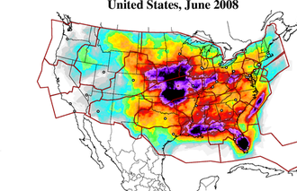
These maps are provided as an aid in evaluating the impact of thunderstorms on the US Airspace System using the methods developed by Slemmer and Silberberg (2004). Convective Sigmets* (CSIG) are issued by NOAA's Aviation Weather Center as a means of advising aircraft pilots of convective activity that is deemed hazardous to aviation. Convective Sigmets are text bulletins routinely issued on an hourly basis at 55 minutes past the hour, as well as times between hours (non-routine issuances) when areas of convection develop rapidly. Each CSIG is a subjectively drawn polygon, line, or circle that depicts convection whenever a specified set of criteria are met.
Map development involves a number of steps beginning with the CSIG text bulletins which are collected and archived on a daily basis at NCDC. At the end of each month, all CSIG reports are compiled and subjected to an analysis routine that identifies the location of all convective sigmets that were issued during the month. (Non-routine CSIG reports are not included in this analysis in an effort to avoid double-counting the occurrence of CSIG reports.) The location of each convective object (cell, area, or line) is based on latitude/longitude coordinates, which are made to overlay an array of 8km x 8km grid boxes across the continental US and its surrounding waters. As each CSIG is evaluated, the 8km x 8km grid boxes that are part of the CSIG object are identified and tallied throughout the month. The Monthly CSIG frequency is the total number of "hits" per grid box divided by the total number of hours during the month.
The frequency of CSIG reports was calculated from January 1995 through December 2004** and the average frequency of occurrence throughout the contiguous US determined for each month. Calculation of the 10-year averages for each month allows the subsequent calculation of CSIG departures from average for any month within the 10-year period as well as any month subsequent to that period. As such, updates to the CSIG database continue to be made and maps of total CSIG frequency as well as CSIG departures from average (anomaly) are provided each month. The hourly mean (00:00 - 23:00 UTC) for each month (January - December) is also calculated for the 10-year period (1995-2004).
Maps of the monthly frequencies are available for any month from January 1995 to the present. Maps for the 10-year mean of each hour of the day for each month are also available. These maps can be accessed via pulldown menus. Currently available are maps for the contiguous US, five regions (Northeast, South, Central, Southwest and Northeastern Coastal Waters), the 20 ARTCCs and 21 of the nation's major airports. Each airport is presented with 75 nautical mile (NM) circles surrounding the airport, with the exception of Washington Dulles (DCA) which has a 100 NM circle and LaGuardia which has a 90 NM circle.
Additional information on the methods used in developing these products is available via Slemmer and Silberberg (2004).
*Convective Sigmets are weather advisories concerning convective weather significant to the safety of all aircraft. Convective SIGMETs are issued for tornadoes, lines of thunderstorms, embedded thunderstorms of any intensity level, areas of thunderstorms greater than or equal to VIP level 4 with an area coverage of 4/10 (40%) or more, and hail 3/4 inch or greater.
**These maps appear to suggest the occurrence of an increase in the frequency of convective activity during this 10-year period. However, it is unclear whether this increase is due to shifting weather patterns or results from improvements in technology and forecasting procedures that result in an increasing number of CSIG reports in the first decade of the 21st century.