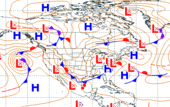
Wed, 26 Aug 2009 07:00:00 EDT A cold front extending from the Northeast into the Southern Plains will trigger showers and thunderstorms. Much of this activity is expected to be scattered in nature, however a string of weak upper level disturbances could produce some more organized storms across parts of the Central Plains and Mid-Mississippi Valley. Further to the north, showers and thunderstorms are expected to accompany a low pressure system moving eastward along the Canadian border from North Dakota to Minnesota on Thursday. Across the Southeast, a stationary front extending across the eastern Carolinas into the interior Southeast is forecast to dissipate, In the moist and unstable air mass, scattered afternoon and evening thunderstorms are forecast. Latest local weather forecasts, warnings, watches, and advisories...
Wed, 26 Aug 2009 06:20:18 EDT Ozone levels in the Unhealthy for Sensitive Groups range are forecast today for Auburn, Bakersfield, Fresno, the Sacramento area, portions of Los Angeles, and Visalia, California, the Baton Rouge area and Lake Charles, Louisiana, Oklahoma City, Oklahoma, and Dallas-Fort Worth, Texas. An Air Quality Action Day has been declared for Baton Rouge, Lake Charles, and Dallas-Fort Worth. Details...
Atlantic Tropical Storm Danny Wed, 26 Aug 2009 16:45:15 EDT At 500 PM EDT the center of Tropical Storm Danny was located about 390 miles east of Nassau and about 735 miles south-southeast of Cape Hatteras North Carolina. Movement was toward the west-northwest near 12 MPH. Maximum sustained winds are near 45 MPH with higher gusts. Slow strengthening is possible during the next couple of days. Details...
Wed, 26 Aug 2009 06:26:51 EDT Excessive heat is expected over the lower Arizona and California Deserts by this Friday. Strong high pressure developing aloft combined with drying in the lower atmosphere will lead to another hot period Thursday into Friday. Details...
Wed, 26 Aug 2009 06:51:48 EDT Approximately 40 reports of severe weather were received on Tuesday mostly across parts of the Central United States, especially in Kansas and Texas. No significant damage or injuries were reported. For today, no organized areas of severe weather are expected. Details...
Eastern Pacific Tropical Storm Ignacio Wed, 26 Aug 2009 16:50:12 EDT At 200 PM PDT (500 PM EDT) the center of Tropical Storm Ignacio was located about 935 miles west of the southern tip of Baja California. Movement was toward the northwest near 12 MPH. Maximum sustained winds are near 45 MPH with higher gusts. Weakening is forecast during the next 24 hours and Ignacio is expected to become a tropical depression tonight and degenerate into a remnant low on Thursday or Thursday night. Details...
Central Pacific Tropical Storm Hilda Wed, 26 Aug 2009 16:55:08 EDT At 1100 AM HST (500 PM EDT) the center of Tropical Storm Hilda was located about 520 miles south-southeast of Hilo Hawaii and about 710 miles southeast of Honolulu Hawaii. Movement was toward the west-southwest near 9 MPH. Maximum sustained winds are near 45 MPH with higher gusts. Little change in strength is expected in the next 24 hours. A slight increase in strength is forecast in 36 to 48 hours. Details...