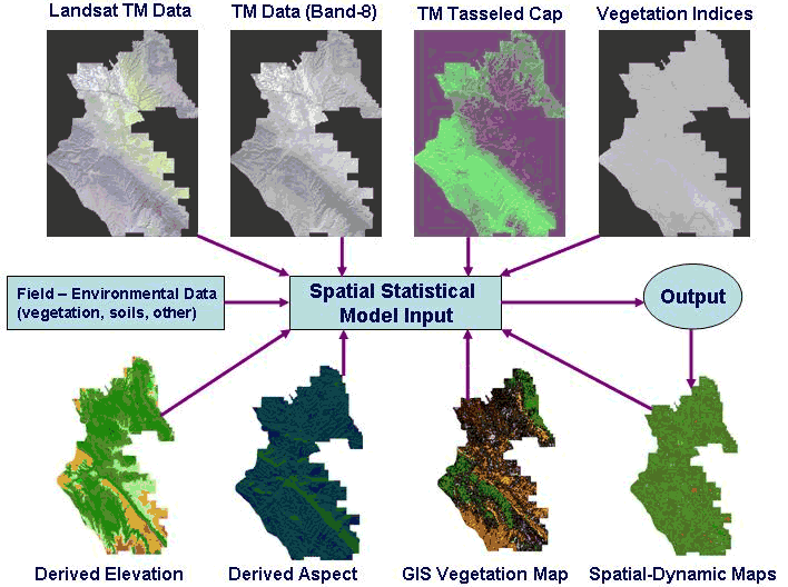
High-resolution mapping of biological resources is central to confronting the invasive species threat. Finding small populations of invasive species is particularly problematic where remote sensing is concerned. To meet the needs of invasive species science and policy communities, one must be able to identify dominant plants and vegetation structures with a reasonable ability to distinguish between species (Figure 1). Such identification is becoming possible with hyperspectral instruments at meter-scale resolutions, particularly when combined with light detection and ranging (LIDAR) technology and other active sensors that can detect meter-scale vegetation structure, landforms, and soil surface properties. The USGS uses advanced geostatistical methods, many derived with NASA Earth Science Enterprise support, to integrate multiple types and scales of data (including satellite images, aerial photography, and field data of various resolutions) for mapping biological resources (Figure 2).
 |
|
Figure 1. Mapping ecosystem attributes to predict species distributions and areas vulnerable to invasion. |
 |
|
Figure 2. Steps for developing spatial statistical models for predicting exotic species invasions. The USGS uses geostatistical methods, many derived with NASA Earth Science Enterprise support, to integrate satellite, airborne, and ground data into predictive models that account for both large- and small-scale variability in landscape structure and biological resources. |

![]() U.S. Department of the Interior | U.S. Geological Survey
U.S. Department of the Interior | U.S. Geological Survey
URL: http://www.fort.usgs.gov/resources/spotlight/EcoForecasting/EF_mapping.asp
Page Contact Information: AskFORT@usgs.gov
Page Last Modified: 3:46:09 PM
