NESDIS banner image
Office of Satellite Data Processing & Distribution
Information Processing Division
   
Product Systems Branch
Computer Operations Branch
CLASS
 
Comprehensive Large Array-data Stewardship System Computer Operations Branch Product Systems Branch link with links to EPS, SPP, Winds, Ozone, MODIS,Images, Soundings, Calibration, and Navigation/Earth Location information

link to the NOAA Home page  link to the National
Environmental Satellite, Data, and Information Service Home Page

Sea Surface Temperature (SST) Contour Charts

SST contour map
^M
******************************************
The web site link was changed to http://www.osdpd.noaa.gov/ml/ocean/sst/contour.html Please make a note.
The browser will automatically go to new site within a few seconds.

An ice mask, courtesy of the National Center for Environmental Prediction (NCEP), is available as part of the 50 km Global SST images.

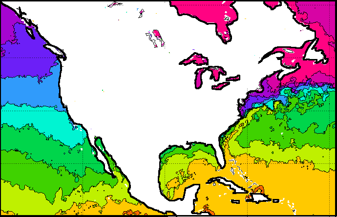
For the colored field and contoured field images, pixels with an observation age greater than 303 hours (or 12.6 days) are colored brown. The maximum and minimum sea surface temperature for these images are computed excluding the brown pixels whose SSTs are unreliable due to their age.


Regularly Updated Sea Surface Temperature (SST) Imagery:
SST contour charts | SST analyzed fields | high resolution CoastWatch imagery

Regularly Updated Operational Coral Bleaching Monitoring Products:
50 km Nighttime SST | SST Anomalies | HotSpots | Degree Heating Weeks | Coral Bleaching Virtual Stations | Satellite Bleaching Alerts

Regularly Updated Animations of Operational Coral Bleaching Monitoring Products:
50 km Nighttime SST Animations | Anomaly Animations | HotSpot Animations | DHW Animations

Retrospective Coral Bleaching Monitoring Products:
1983-1998 SST monthly means | 1983-1998 SST monthly mean Anomalies | 1998 coral bleaching events and animations | 1998/1999 seasonal DHWs | 1985-1999 SST time series for 24 global coral reef sites

Other Links of Interest:
Ocean Surface Winds | ORA Satellite Oceanography Division | Comprehensive Large Array-data Stewardship System | National Climatic Data Center | Polar Orbiter Data and NOAA KLM User's Guides


Privacy Policy | Disclaimer

Last Modified March 03, 2008 (jw)

Contact Environmental Products team.

Contact OSDPD Webmaster.

Computer Operations Branch Comprehensive Large Array-data Stewardship System Computer Operations Branch CLASS
NOAA/NESDIS/OSDPD; Revised March 03, 2008