|
NOAA
03-460-1 FOR IMMEDIATE RELEASE Contact: Glenda Powell 10/23/03 |
NOAA
News Releases 2003 NOAA Home Page NOAA Public Affairs |
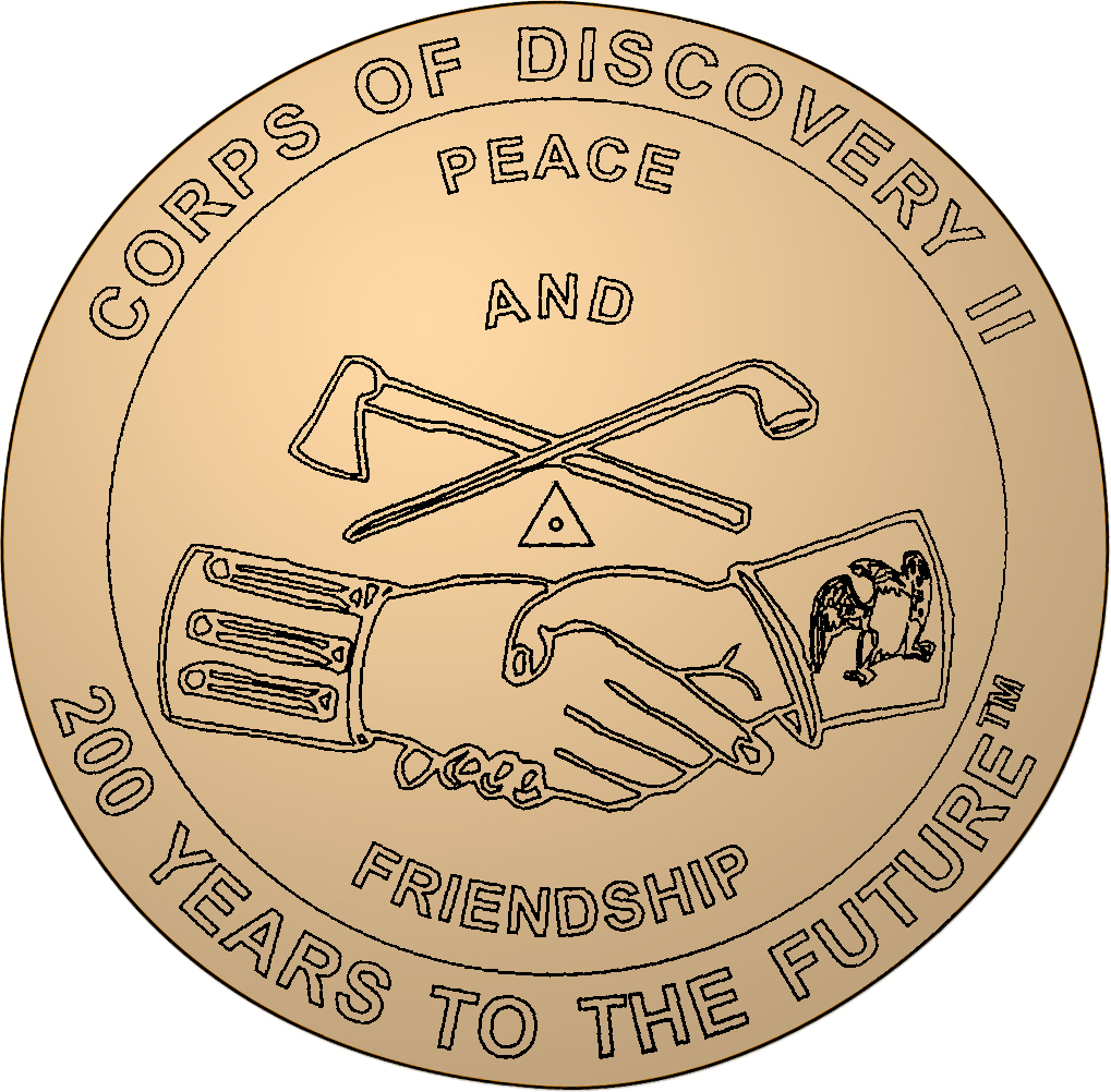
On October 25, 2003, the National Oceanic and Atmospheric Administration (NOAA) and Clarksville, Ind., will celebrate the bicentennial of the Corps of Discovery Expedition, led by explorers Meriweather Lewis and William Clark 200 years ago. NOAA’s National Geodetic Survey (NGS) will set a commemorative marker in Clarksville, along the trail traveled by the legendary explorers. The ceremony will be held at the George Rogers Clark Home Site at 11 a.m. NOAA is an agency of the U.S. Department of Commerce. Equipped with only a few basic surveying tools, Lewis and Clark literally measured their way across unknown territory. Beginning at Wood River, Illinois, in 1804, Lewis and Clark spent the next two years traveling through newly acquired territory that now includes Missouri, Kansas, Iowa, Nebraska, South Dakota, North Dakota, Montana, Idaho, Oregon and Washington. They reached the Pacific Ocean in 1805 and traveled back in 1806. In January 2003, the Corps of Discovery II Expedition began retracing the steps of Lewis and Clark. NGS placed a marker at Monticello in Charlottesville, Virginia, the home of Thomas Jefferson and symbolic starting point of the expedition. Jefferson initiated the Corps of Discovery Expedition with a letter to Congress in 1803. The design of the marker is based on the Jefferson Peace Medal, a memento that Lewis and Clark presented to American Indian leaders as they traveled west. The commemorative expedition will continue through 2006. “Jefferson had an image of America as a land of small property ownership and well-defined boundaries,” said Charlie Challstrom, director of NGS. “Lewis and Clark executed this vision, measuring their way across America with only a few basic surveying tools and resources at hand. Today, the geography of America continues to be more accurately depicted through NOAA and NGS use of advanced positioning technology.” Each commemorative marker is located using a Global Positioning System (GPS) device. The coordinates derived are a part of the National Spatial Reference System (NSRS), which serves as the nation’s geodetic reference framework for latitude, longitude and elevation. NGS establishes and maintains NSRS, providing the foundation for transportation and communication systems, boundary and property surveys, land record systems, mapping and charting, and a multitude of scientific and engineering applications. As a surveyor, Thomas Jefferson had a vision for a clear delineation of the United States coastline to reduce shipwrecks while expanding commerce and industry. Jefferson created the Coast and Geodetic Survey (CGS), to focus on the importance of geodesy, the science of measuring the size and shape of the earth, and the nation’s coasts. After a federal reorganization in 1970, part of CGS became National Geodetic Survey, falling under the NOAA umbrella. NOAA’s National Ocean Service, which includes NGS, is dedicated to exploring, understanding, conserving and restoring the nation’s coasts and oceans. It balances environmental protection with economic prosperity in fulfilling its mission to promote safe navigation, support coastal communities, sustain coastal habits and mitigate coastal hazards. NOAA is dedicated to enhancing economic security and national safety through the prediction and research of weather and climate-related events and providing environmental stewardship of our nation’s coastal and marine resources. On the Web: NOAA: http://www.noaa.gov/ NOAA National Ocean Service: http://oceanservice.noaa.gov NOAA National Geodetic Survey: http://geodesy.noaa.gov Pictures of commemorative marker: Web image: http://www.noaanews.noaa.gov/stories/images/lewis-clark-marker.jpg High
resolution: http://www.noaanews.noaa.gov/stories/images/lewis-clark-marker2.jpg |
|