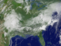
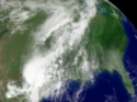
 | Daily Imagery May 5, 2009
A low pressure system moving over the Midwestern and Eastern United States. This system is producing showers and storms over parts of these regions. |
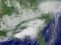 | Daily Imagery May 4, 2009
A low pressure system extending from the Southeast up to the Northeast. This system is producing heavy rain and severe storms over parts of these regions. |
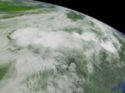 | Daily Imagery May 1, 2009
A frontal system moving over the Midwestern and Southern United States. This system is producing heavy rain and thunderstorms. |
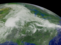
 | Daily Imagery April 30, 2009
Showers and storms moving over parts of the Midwestern, Southern and Eastern United States. |
 | Daily Imagery April 29, 2009
Heavy rain and thunderstorms over parts of the South, Midwest and Western Plains. |
 | Daily Imagery April 28, 2009
A frontal system that extends from the Southern to Northeastern United States. This system is producing showers and thunderstorms over parts of these regions. |
 | Daily Imagery April 27, 2009
A front developing in the Mid-West is bringing flash-flood warnings to Texas, Kansas and Missouri. This GOES-12 visible image was taken on April 28, 2009 at 1915z. |
 | NOAA Kids Day Image - Douglas
GOES infrared imagery is shown from over the East Pacific on April 23, 2009. |
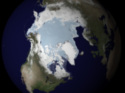 | NOAA Kids Day Image - Laurie McSweeney
This image is looking at the sea ice concentration and extent in the North Pole on April 23, 2009 using data from the SSMI sensor on the DMSP satellite. |
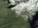 | NOAA Kids Day Image - Idaysha Hawkins
A GOES ssatellite view of the Chesapeake Bay on April 23, 2009 taken by Idaysha Hawkins. |
| More Images... |