Click here to skip navigation.Minerals Management Service MMS - Gulf of Mexico RegionSearchTopic IndexAbout MMSWhat's New U.S. Department of Interior
MMS - Gulf of Mexico Region
Plans Tracking Information
Deepwater Information
Information on Floating Production, Storage and Offshore Loading (FPSO's)
Royalty Relief Information
Safety Information
Overview of OCS Regulations
Notices, Letters, and Information to Lessees and Operators
Offshore Gulf of Mexico Atlas Project
Fields & Reserves Information
Assessment of Conventionally Recoverable Hydrocarbon Resources of the Gulf of Mexico and Atlantic Outer Continental Shelf
Eastern Gulf of Mexico Activities
Atlantic OCS Area Activities
Gulf OCS Region Activities
Proposed Offshore LNG Receiving Terminals in the Gulf of Mexico
Spacer Image
News Releases, Papers, Publications, Speeches, and Innovative Achievements ProgramUpcoming EventsFast FactseWell Permitting SystemProducts/Free DataAtlantic Information
Deep Gas in Shallow Water
Offshore Information
Lease Information
Environmental Information
Production Information
Hurricane Information
Online Ordering System
Public Information Ordering System
Public Information Data System
MMS Ocean Science
Spacer ImageNew e-Government Transformation Project, OCS Connect
Freedom of Information Act (FOIA)
MMS Forms for Lessee and Operators
Job Opportunties at MMS
Kid's Information Page
Privacy Act/Disclaimers
Accessibility
MMS Information Quality Guidelines
Subscrbe to Mailing Lists
Navigation Tips
Contact Us
Spacer Image The U.S. government's official
web portal
Spacer Image
Questions? Need More Information?

This page last updated: February 19, 2008


This is a common underwater scene around the offshore platforms in the Gulf of Mexico. The same animals that live on natural reefs, tropical fish and encrusting organisms, create "artificial reefs" on a platform's structure in the water. This photo was taken at BP Exploration's "Snapper" production platform in the Western Gulf, about 105 miles southeast of Galveston in 863-foot waters. Gulf OCS Region Activities

The MMS Gulf of Mexico Regional Office conducts all leasing and resource management functions on the Outer Continental Shelf (OCS) for the Gulf of Mexico and the Atlantic area.  The three planning areas in the Gulf Coast contain approximately 37 million acres under lease.  
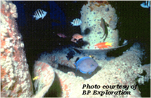
There are 3,728 offshore production platforms active in the search for natural gas and oil on the Gulf of Mexico; these contribute significantly to the Nation's energy supply.

Subsalt Exploration

Indicated Hydrocarbon List

Sand and Gravel Mining

Above statistics updated 08-04-2009 01:23:40 PM.


Privacy | Disclaimers | Accessibility

Home | Search | Topic Index | About MMS | What's New | Press Releases/Reports
Upcoming Events | Fast Facts | Products/Free Data | Deep Gas | Offshore Info | Lease Info
Environmental Info | Production Info | Hurricane Info | Online Ordering System | P.I. Data System
MMS Ocean Science | OEMM e-Gov | Forms | Jobs | Kid's Page | FOIA | Info Quality Guidelines
E-Mail Subscriptions | Navigation | Contact Us